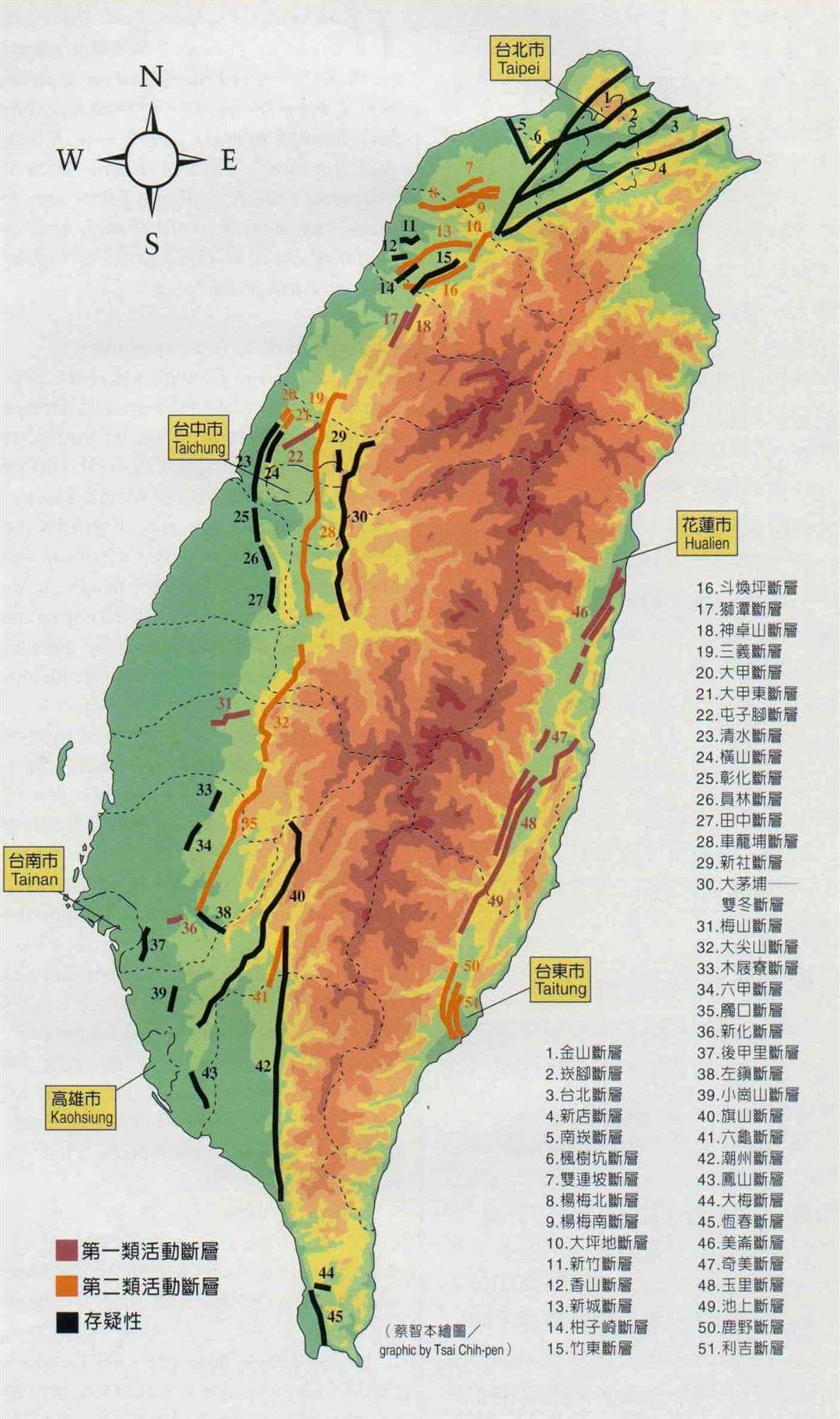
The fault extends
Three years ago the CGS took action to rectify this situation, by starting new and intensive research into fault lines. Work the first year was devoted to research on three southern fault lines that concern geologists most. The second year it completed a report on four fault lines in Taipei. This year it is making a survey of fault lines in central Taiwan, including the Chelungpu fault line. No one had expected that not long after this work had begun, the Chelungpu fault would rock the island.
Because past surveys of Taiwan faults were mostly limited to examinations of surface geology, with no money to obtain more precise results by digging or drilling under the surface, major mistakes were common. Particularly in metropolitan areas where high real estate prices mean that all the land is covered by buildings, ruptures are impossible to see. After the Chichi quake, Lee Yuan-tseh, the president of the Academia Sinica, heard that a Taipei fault supposedly ran past the Academia Sinica, so he asked experts from the Institute of Earth Sciences to look for the fault both in front of and behind the Academia Sinica. Unable to see anything, they couldn't ascertain where the fault was running.
Now, in the wake of the disaster caused by the Chelungpu fault, the National Science Council has started carrying out its own research into fault lines in addition to the fault-line surveys being conducted by the CGS. But will appointing people to spend time and money researching faults really give us control over them?
After the Chichi quake rescue teams rushed to the scene of the disaster from across the island and around the world. Likewise geologists from north, south and central Taiwan mobilized to trace the fault. Yet these experts didn't all chart the fault lines the same way. Wang Chien-ying, a professor of earth sciences at National Central University, arrived at the scene only four hours after the quake. Five days later he came to the conclusion that the fault had bent, a notion that didn't mesh with the previous consensus that the Chelungpu fault directly connected to the Sanyi fault farther north. Separate groups of experts went to the area around Shihkangpa to investigate the turn in the fault. They discovered that there is no more apparent logic to how this fault changes course than to how hairs in an ink brush clump.
Faults can bend
After the Chichi earthquake, the government urgently wanted experts to chart the fault line accurately, so that it could delineate a surrounding zone in which building would be prohibited. But surface ruptures caused by a fault don't necessarily run in a straight line or fit in a regularly shaped area. Like a piece of glass, the earth along a fault doesn't shatter cleanly: the lines zigzag and the fragmentation is irregular.
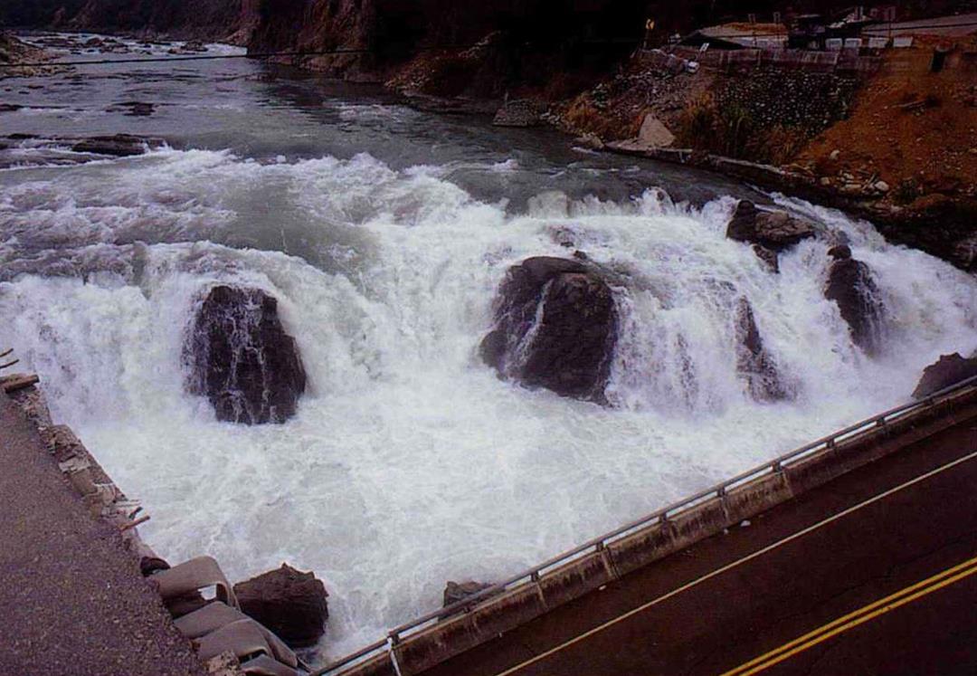
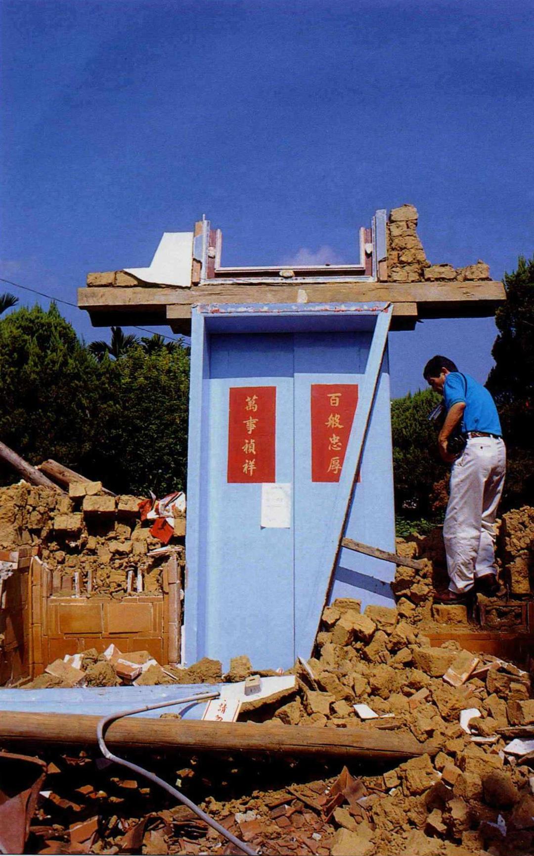
Along the southern section of the fault, surface ruptures occurred within a belt ten or 20 meters across, whereas along the northern section of the fault, fractures branched off within a belt measuring as much as three kilometers across. In the provincial government's Chunghsing Village a new office building and an old office building toppled over and everything in between was completely undamaged. Lacking an understanding of faults' complexity didn't stop people from offering interpretations to match their political viewpoint. "Look," some would say, "even the gods aren't happy with the disbanding of the provincial government!" "Disbanding the provincial government wasn't enough," others argued. "See how the gods acted to destroy it."
"It is indeed very hard to draw an accurate and detailed map of geologic fault lines," explains Shih. Even if you know there's a fault line under your house, who can say that the next quake will strike there? And you can't always find clear surface evidence of an active fault. Without more extensive surveys, we may be able to say that a fault line is probably somewhere in a general area, but rarely can we say with any certainty that it's right there, under that road. While a fault can often be placed in a belt-like zone, to narrow its path down to one thin line is very difficult.
But no matter how hard it may be to trace a fault, you have to put the fault lines on a map, because there is a greater likelihood that geological stress will be released along already existing faults than anywhere else.
Even if an earthquake doesn't strike again in the near future, the earth around previously active faults is loose and the geological strata unstable, so it is best not to build there. The Council of Agriculture's Taiwan Animal Health Research Institute used to stand on the Hsinhua fault in Tainan. The director's office gradually sank and his nerves frayed until he finally couldn't take it any longer and went to geologists for help. When they told him the building was on a fault, he moved it. Laochuan Li in Mucha, Taipei City is the site of mudslides and rockslides whenever it rains. The CGS blames them on the Hsintien fault.
Nature isn't a still life
What's more, Taiwan is very windy and rainy, and if you don't mark out a fault line right after a quake, all evidence of it soon disappears. It is already impossible to determine the exact location of most stretches of the Hsinhua fault, which was created just this century. Did you hear the joke about the Meishan fault? When National Chung Cheng University was being planned, some experts said that the Meishan Fault ran under the site for the campus, and others said that it didn't. When construction was to begin, neither side had given an inch. The university administration decided to just go ahead and build and resolve the matter later. The disagreement made them think that earthquakes were worth studying, so they resolved to open an institute of seismology. If nothing else, they thought, perhaps it would serve to press down on the fault and keep it from moving.
In fact, scholars have been studying the Meishan fault for many years. "There is still disagreement as to whether it passes under Chung Cheng University," says Lin Chin-wei. Does this show that earth science doesn't offer easy answers?
"This isn't unusual in the least," says Wang Chien-ying, who confesses that science has proven rather powerless when confronted with the earth. "Can you rely on people's eyes to describe the enormity of the earth or the sky? The object of study can't fit inside a laboratory." It is said that three geologists asked the same question will come up with six different theories, each keeping one as a spare. This is because so much about nature is unfathomable.
Many people criticize the CGS fault map for being riddled with inaccuracies. The CGS's Chang Hui-cheng explains that geological activity has a life of its own, with different stages of development. What everyone sees are just the phenomena of a specific time and place. Fault ruptures may very well have been different last time than they are this time. The major earthquake that rocked Turkey in August involved the Anatolian fault in northwestern Turkey. A new rupture zone extends out from the middle of the fault in a northeasterly direction. But this isn't causing the scientific community to doubt the reliability of the original map. If people are well informed, they won't blindly expect the scientific community or government to provide them with a 100% accurate, unchanging map of fault lines.
No fault on this side!
The emphasis on fault maps overseas is also rooted in tragedy. After the San Francisco earthquake of 1906, scientists began paying attention to faults. But it wasn't until after the Los Angeles quake of 1971, which resulted in surface ruptures, that California passed the Alquist-Priolo Act, which mandated that all known faults be put on a map at a scale of 1:24,000. After the agencies performing the survey had completed their geologic fault maps, they were required to publicize the fact for ten days, and then give academics 90 days to make revisions, before releasing the maps to local zoning offices. After this long involved process, the best they could do was to designate a 400-foot-wide "fault zone." If the construction industry wants to build within this zone, it must hire professionals to undertake a more detailed survey to determine the precise location of the fault. Within 50 feet, only non-residential structures such as warehouses can be built.
California is currently one of the few places in the world that has adopted a systematic plan to deal with faults. Though Japan is greatly admired by Taiwan for its earthquake preparedness, its zoning regulations don't currently take fault lines into consideration.
Shih believes that California legislators demanded only 1:24,000 maps because they understood the practical difficulties in tracing faults, and only intended these maps to be used as a general reference. More important was the requirement that construction firms be responsible for detailed on-site surveys before starting to build. There's a joke among geologists about the Taiwan construction industry taking the CGS 1:100,000 scale map and blowing it up to a size large enough to suit their purposes. After being blown up, there is a margin of error of several kilometers, which allows builders in the southern side of a fault zone to say the fault is in the north, and those on the northern side to say it is in the south. Thus, builders on both sides can conclude that their own sites are exceptionally stable.
Building smart
The September quake has given geologists more ammunition in their campaign for legislation that would mandate nationwide collection of geological data and surveys of underground water resources, as well as strengthen geological education and conservation and require builders to obtain geological safety certificates before starting construction.
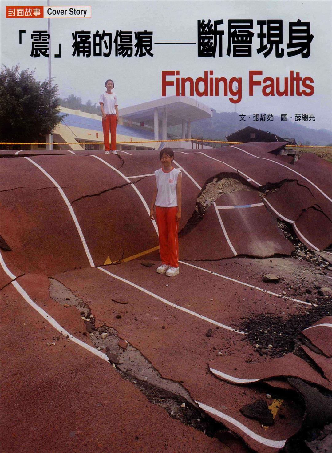
The Chelungpu fault became famous overnight after destroying more than 10,000 homes and causing great loss of life. But there's more that we can do than merely pray for the gods to take pity on us and keep the fault from moving again. At the very least, let us hope that while living in peace we can stop and think before we build. In addition to hiring an architect to design an attractive building and a structural engineer to assure a sturdy structure, let us go a step farther and show concern about the geological integrity of the sites where we build. Only by so doing can we prevent further tragedy.
@List.jpg?w=522&h=410&mode=crop&format=webp&quality=80)


@List.jpg?w=522&h=410&mode=crop&format=webp&quality=80)