It could go off at any time
Compared to the peak flood volume during Morakot of 400 million tons per day at the Xinpi Bridge downstream, the flood dissipation capacity of the Dachaozhou artificial lake would be indeed pathetically small. It is for this reason that recently the county government has altered the orientation of the water management plan.
Tsao Chi-hung tells us that the county government plans to use two methods-low-lying dikes and water diversion channels-to drain off some water into the Taiwan Sugar reforestation area when there is threat of flooding, to reduce the burden downstream. However, the 300-hectare artificial lake project will still go forward, seeing as its main purpose has always been to inject water into the underground water table to prevent further subsidence, and the environmental impact assessment has passed.
Although the amount of land that the county government has designated for flood diversion-1500 hectares-is somewhat less than that hoped for by environmental groups, the spirit of "allowing flood waters to drain off into a flood plain" is identical.
Strategy 3:Rezoning downstream
Coming back to the issue that started all this off, assuming that the comprehensive management plan for the river succeeds, does this guarantee that the downstream dikes will never collapse, and that low-lying Linbian and Jiadong will enjoy worry-free futures?
"This can only reduce the threat and the damage," says Tsao Chi-hung. In fact, both the government and citizens need to change the commonly ingrained idea that "dikes equal safety." Severe rains of the scale brought by Morakot will always run down toward severely subsided land along the coast.
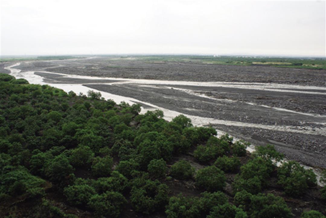
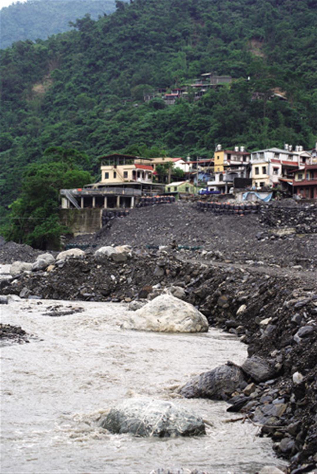
Moreover, according to estimates by National Taiwan University geosciences professor Chen Hongey, landslides in the upstream part of the Linbian River during Morakot released 80 million cubic meters of soil and sand, which is four times what is dredged out of rivers in all of Taiwan in an entire year! Even if the entire island's dredging capacity were directed to this one location, and there were no more landslides at all, it would still take a decade to digest such an amount of soil and sand, so in fact "cleaning out the river" is a mission impossible, making the threat of downstream flooding even more serious.
Tsao Chi-hung reveals that, given this precarious situation, future reconstruction in Linbian and Jiadong will be conducted in accord with the long-completed comprehensive plans of the Council for Economic Planning and Development for drainage and environmental rehabilitation in areas with severe subsidence (see page 22). This novel approach, with compulsory purchasing of land by the government and rezoning of inhabited areas, will allow the most flood-prone areas to absorb floodwaters, while elsewhere the level of the land will be raised to provide someplace for people to live, and parts of the aquaculture and agriculture industries will be transformed into eco-industries.
Academia Sinica Earth Sciences Institute researcher Wang Chung-ho relates, "In the past, the government always deferred to public opinion in areas of severe subsidence along the coast, and didn't dare propose relocating the communities. They always hoped that the residents would themselves realize the danger and leave of their own accord." But now that climate change is weighing in, the government is being forced to confront the problem head-on, and to dust off long-shelved national land-use plans. This is the only way to escape the vicious cycle of investing huge sums of money on "protective" dikes that merely encourage risk-taking and lead to greater losses later on-invariably followed by calls for more protective dikes!
The Water Resources Agency has commissioned Lee Hong-yuan, a professor of civil engineering at National Taiwan University, to create a model zone of this type along the Chiayi coast. He says that if the Pingtung County Government has really made up its mind to follow the Chiayi model, there should be no problem coming up with a plan, and initial estimates of the cost are only NT$600 million. The main hitch will be implementation.
In Chiayi, for example, his team spent more than a year drafting a plan and communicating with local residents, who have suffered enough from flooding to be ready to accept a radical solution. The Chiayi County Government also has been enthusiastic. But such a major project involves 10 specialist government agencies under six different ministries, which have conflicting interests, so there has to be an extremely powerful coordinating mechanism. In fact, the Executive Yuan has already approved the spending of the money, but no one knows who is going to be in overall charge of the project.
Reconstruction projects will inevitably be difficult and time-consuming, but one short sharp pain will be better than stretching out the agony. Typhoon Morakot has created an opportunity for transformation, but it is only by turning ideas into action that the 600 souls who perished will not have died in vain.
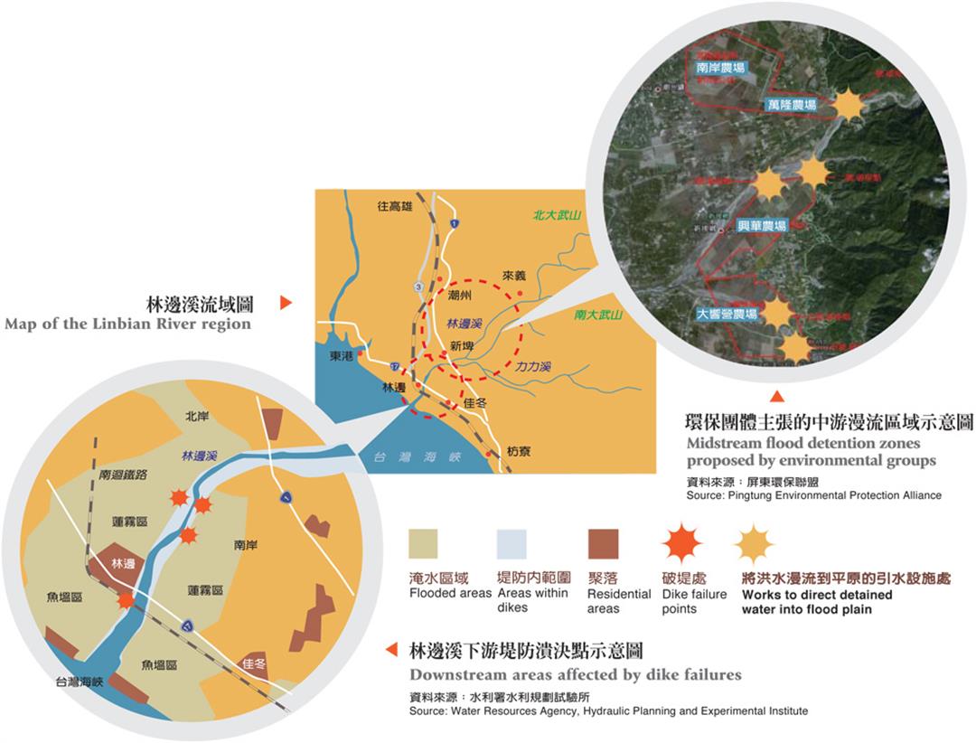
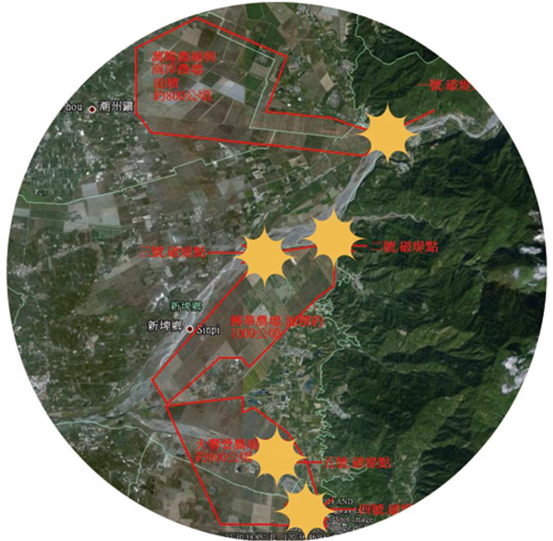
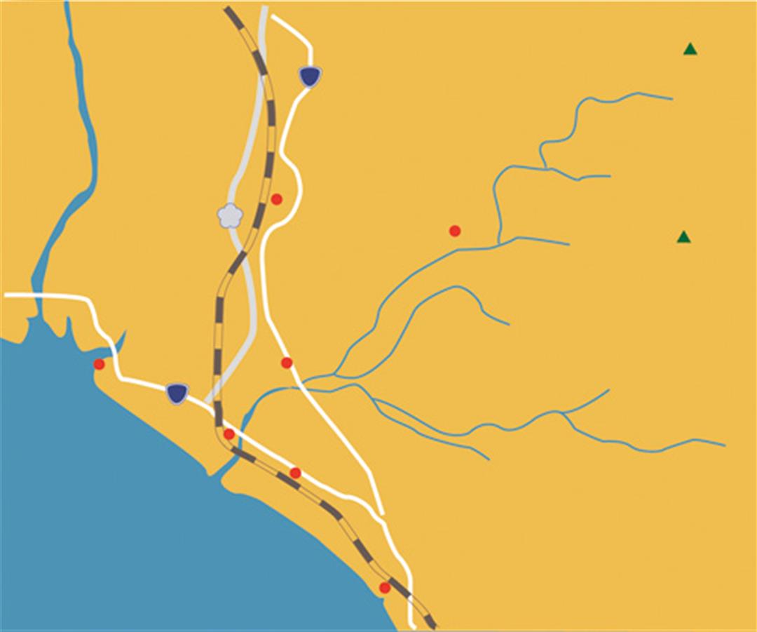
Map of the Linbian River region、Midstream flood detention zones proposed by environmental groups、Downstream areas affected by dike failures
To deal with the problem of water being too much for the dikes to handle, environmental groups hope that the midstream part of the Linbian River can go back to its original state as a "flood plain." Rather than spending huge sums of money on a manmade lake (as is currently planned), floodwater could be far more effectively and cheaply diverted into this broad, 3000-hectare reforestation area.
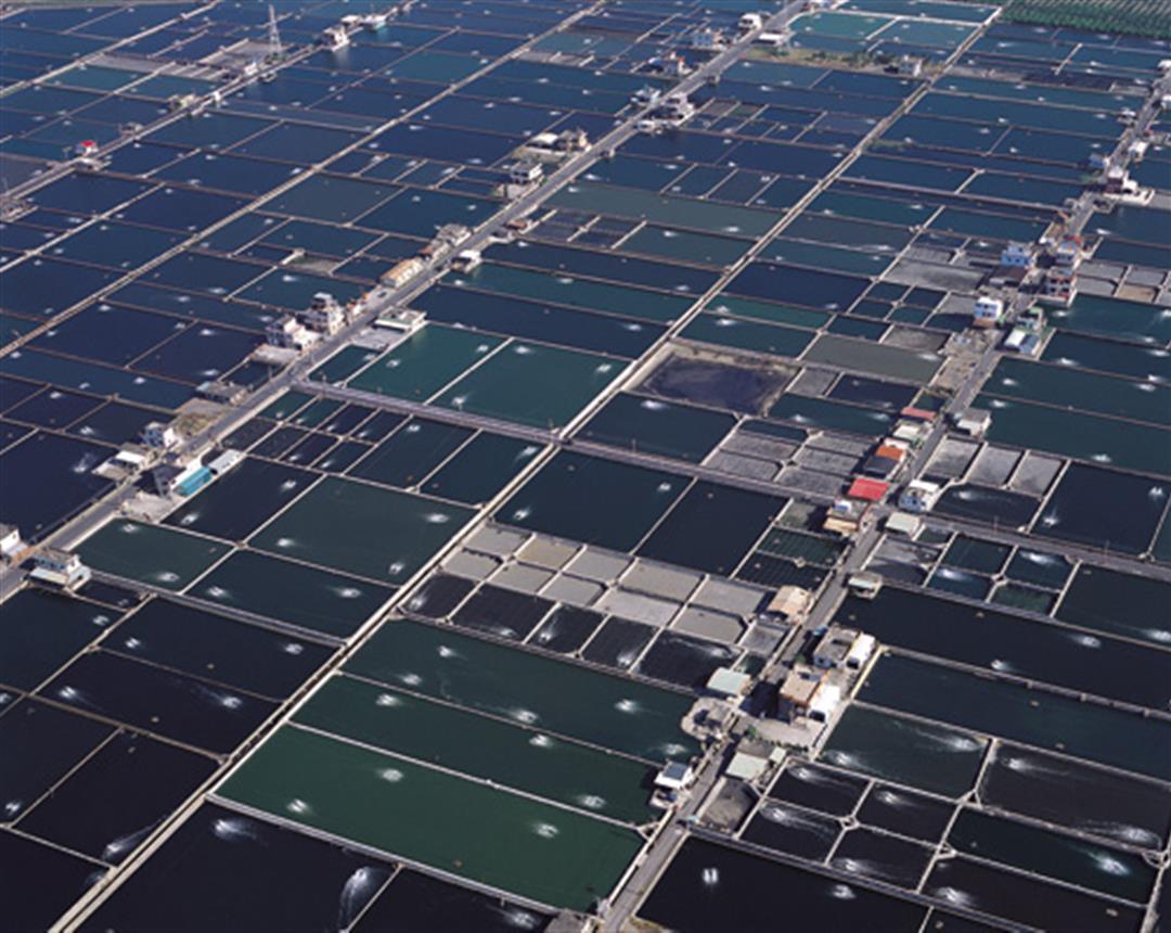
Is this really a fishpond? After the floodwaters of Morakot receded, 1000 hectares of fishponds in Linbian and Jiadong were left buried in mud, and today, two months after the event, still have not been cleaned out. One reason is that, since the soil is national property, only the township government has the right to remove it, but also some fish farmers want to take this chance to raise the overall level of the land to prevent future floods.

@List.jpg?w=522&h=410&mode=crop&format=webp&quality=80)


@List.jpg?w=522&h=410&mode=crop&format=webp&quality=80)