Returning the Land to the Water in Floodstruck Linbian and Jiadong
Coral Lee / photos Hsueh Chi-kuang / tr. by Phil Newell
November 2009

In Linbian and Jiadong, two of the places listed as severe disaster areas from Typhoon Morakot, water levels reached five meters and 30,000 people were made homeless. After the disaster, there were 200,000 visits made by volunteers from throughout Taiwan as well as by military personnel lending a hand in cleaning up debris. But it seems as if the mud will never be completely cleared away, and today, two months later, the fishponds and orchards on which the residents depend for their livelihoods are still scarred and coated with black earth.
These two coastal communities have long been on the environmental blacklist because excessive drawing of groundwater in the past caused subsidence of 3.2 meters. Though there has been some improvement with this problem in recent years as residents have brought in seawater instead, because land that has subsided will never return to its original level, these aquaculture bastions that remain one meter below sea level have not been able to escape a traumatic destiny. When the torrential rains of Morakot hit, the communities were completely submerged after the dikes along the neighboring Linbian River collapsed in several places.
Facing "extreme weather," is the problem really as simple as local residents have made it sound by saying things like "It's all because the government didn't maintain the dike," and "If the dike hadn't washed away everything would have been fine"? Scholars have long been calling on low-lying coastal areas to "cede the land to the sea." Is it practicable to do so here?
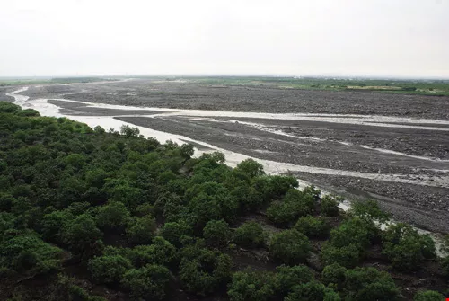
Two months after the August 8 floods and landslides, driving by car into Yanfeng Village in Jiadong Township, where aquaculture is king, the fishponds stretch out farther than the eye can see. Yet you don't hear the sounds of paddlewheel water-aerators spinning away, there is no fishy smell, and you don't see hide or hair of local people coming and going among the ponds. All you see is grey, dried mud under an overcast sky.
Amidst the silence, the home of Wu Rongxin, director of the Linbian Fishermen's Association, is quite a change of pace. Eight or nine fish farmers have been invited over for tea, and Wu says, with a laugh that reveals a touch of bitterness, "Ask as much as you like, anyway we haven't got anything else to do!" Recalling the day of the disaster, he says, "Within 15 minutes the water was up to the second story. It was so fast it was just like that movie The Day After Tomorrow. I didn't even have time to try to get the refrigerator to a higher place, I just ran for my life up the stairs." He takes out a photo that he shot from the second floor, showing nothing outside the house but a sheet of roiling water, and they even picked up a 20-kilogram giant grouper fish right off the floor. "Luckily the flood happened during the day. If it had flooded like that at night, I don't know how many people would have been trapped and killed!"
Two days later, the water had receded by half a story, but then stopped. With the pumping station completely knocked out by floodwater, this land whose topography placed it below sea level would never drain by the forces of nature alone. Eventually the central government delivered more than 10 large water pumps, which had to be kept running night and day for over a month before the job was finished. For local residents, the worst part of the aftermath was that there were dead fish everywhere-calculated at the rate of 12,000 kilograms of fish per hectare, and given Jiadong's 500 hectares of fishponds (two thirds of which were stocked with grouper), there were 6 million kilos of dead fish, spreading a foul odor everywhere and creating a massive mosquito and fly breeding ground.
Jiadong and Linbian were, until inundated by the floods of Morakot, Taiwan's "grouper kingdoms." The Fisheries Agency of the Council of Agriculture, calculating based on production costs per fish, announced that the complete destruction of the fish farms in the two townships caused total losses of at least N$2 billion. But fish farmers, calculating at market prices and including lost capital investment, say losses were at least NT$10 billion.
The Linbian River, source of the "nightmare of mud" that has overwhelmed Jiadong and Linbian, suffers from frequent landslides upstream. Rocks washed down by the recent flood smashed numerous free-range-chicken restaurants into oblivion, and the Laiyi Aboriginal community, home to 1100 people, has been deemed too dangerous to remain in; residents will have to relocate.
"From rich men to beggars"
"The production costs per grouper, counting the fish fry, feed, chemical inputs, pond aerators, and human labor, come to about NT$120, which means that costs per hectare are roughly NT$4-5 million." Fish farmers relate that at the larger local farms people had invested in five or six hectares of ponds, with losses in the tens of millions, while at the smaller farms of two or three tenths of a hectare, losses were still about NT$1 million. Since most of them had used their land as collateral to take out loans from the Fishermen's Association, and the fish they had spent a year raising were wiped out just as the farmers were about to realize a return on their investment, in a flash people have been left with debts in the millions or even tens of millions!
Opening the map, you see Linbian to the north of the mouth of the Linbian River, while Jiadong is to the south. In those parts of the two townships that lie to the west of Provincial Highway 17, all of the land is below sea level, and residents are mainly engaged in aquaculture. Residents to the east of PH17 are largely in the business of cultivating wax apples; though the topography there is a little higher than to the west, they were devastated just the same.
Cao Liqing, an orchard farmer in Linbian, takes us to see her father's half-hectare wax apple orchard, but all we can see is that about 120 centimeters of pasty black mud has covered everything. "There is no way to clean up most of the orchards around here, because the mud is too deep even to walk into them." Many wax apple trees died after being completely covered in fine mud particles, leaving them unable to breathe.
Pingtung County Council member Cheng Wen-hua points to some sobering facts: Over 400 hectares of wax apple orchards in the two townships were swamped, and there is nothing farmers can do but wait for the mud to dry before cleanup can begin. It will take at least half a year before they can replant, but when you consider that a new tree only begins producing fruit after three years, and a reliably steady harvest at five, farmers are looking at four or five years in a row of little or no income. As for the government's "633" promise-a subsidy of NT$60,000 per hectare lost, plus NT$30,000 each for seedlings and fertilizer-that won't even cover the costs of the machinery for clearing away the mud. The prospects are daunting.
The failed dike
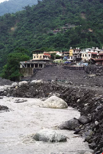
In the past, although there were frequent floods in Linbian and Jiadong, the water could all be pumped out in a day or two, with little effect on transportation or daily life. But Morakot brought a nightmare of mud and floodwaters that won't go away, and people have lost their livelihoods. The fuse that set this off was not, however, seawater flowing onto the land, but something they never thought would happen: the failure of the dikes in the downstream part of the Linbian River.
The Linbian River originates on Mt. Dawu and flows through 470 square kilometers of mountainous terrain. The upstream part, where there are frequent landslides, is marked by large boulders. The water coming downstream, meanwhile, carries mud and sand particles. The dike collapsed in four places, two on the north side (allowing the turbulent waters to swallow up Linbian) and two on the southern side (turning Jiadong into a marshland). (See Map.)

A wall marked by mud stains, a face marked by loss. When will the nightmare be over? Hopefully the reconstruction plan being offered by the government to rezone surrounding land and live in harmony with the river can be implemented quickly, in order to fundamentally address the problems of flooding in these low-lying coastal areas.
Why did the dikes collapse?
Hsieh Sheng-hsin, director of the Pingtung County Water Resources Bureau, states that the dikes on the Linbian River were designed only for a "100-year flood" (i.e. a flood of a severity likely to occur only once in every 100 years), but the rains of Morakot created a 250-year flood, far exceeding the capacity of the dikes. The water flowed over the top of the dikes, washing away the underlying land on the outward side (which on this 30-year-old dike was only earth, not concrete), wiping out the foundations and so causing the dike to collapse.
There have also been claims that the collapse of the dam in two places on the southern bank was due at least in part to the fact that betelnut trees planted on the high bottomland (between river and dike) prevented water from flowing away. However, Huang Chin-kun, a professor in the Department of Hydraulic and Ocean Engineering at National Cheng Kung University, who specializes in river dike construction and bridge safety, suggests that there is no direct connection between the two. Because high bottomland constitutes, as the name suggests, relatively high topography compared to the dike, even if there were no betelnut orchards, the water would still have overflowed and damaged the dike.
As for the 350-meter-long collapsed section on the northern bank, directly across from the betelnut plantations, Huang explains that there is a river bend there (similar to the location of the hotel that collapsed in Taitung), so the water flowed more quickly and powerfully, creating a "submerged scouring" effect. It should also be noted that the flood was at its peak at the time that section began collapsing, and since the peak period of Morakot lasted especially long, it was the incessant pounding that really was responsible for making the gap in the dike as long as it was.
It's hard to prevent natural disasters if Heaven ordains them, and victims can only grin and bear it. But the lower gap in the dike along the southern bank was definitely the handiwork of man.

Whose fault is it?
Much criticism has centered on the design of the bridge that takes the Southern Link Railway over the Linbian River. When this reporter arrived at the gap in the dike by this iron bridge, the bridge was indeed very low, only a meter above the surface of the water in normal times (and thus much lower than the level of the dikes). In fact, even before Morakot the county government expressed worry that, with the bridge being so low, driftwood washed down by heavy rains could get caught in the framework, making it impossible for river waters to escape and resulting in a disastrous flood.
"For 15 years now the county government has been repeatedly asking Taiwan Railway Administration to raise the iron bridge by four meters, so that it would be at least two meters above the dike. But because of lack of funds, the plan has been put off again and again," says Pingtung County Executive Tsao Chi-hung. It was only in 2006, when Su Tseng-chang became premier, that approval was finally given for a new bridge. Unfortunately, Morakot struck before work had been completed, and the bridge did indeed become a "check dam." Blocked from escaping, the water rose and finally broke through a sluice gate in the dike, allowing mud-laden floodwaters to go pouring into Linbian.
The muddy water rushing in clogged all of the drains in Linbian. "Why is it that in the past the pumping station was so useful, but this time it was completely unable to come into play?" asks Cheng Wen-hua, answering his own question metaphorically: If your arteries and veins are all clogged up, it doesn't matter how strong your heart is, it won't do you any good! A month after the disaster, the military had finally cleaned out the main A and B trunk lines, but the drainage ditches in many smaller lanes and roads have yet to be cleared, so that they flood on every rainy day.
For now the county government has plugged up the four gaps in the dikes with steel plates and sandbags. But how can dike safety be improved for the future? Hsieh Sheng-hsin explains that they will proceed in accordance with the plans drawn up by the Water Resources Planning Bureau of the national government: They will raise the dike in the downstream section, where the land in Linbian and Jiadong has subsided, by 50 centimeters. They will also lay down concrete for the foundation on the side of the dike that faces away from the river, in the hopes that even if the river overflows the dike again, it won't wash away the foundation like it did during Morakot. Finally, in a few places on the river-facing side of the dikes where scouring is more of a threat, they will place "gabions" (wire netting filled with rocks) and wavebreakers so that the dike will not be subject to such severe pounding.
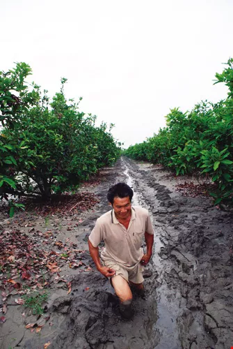
Jiadong and Linbian are also important centers for the production of premium "Black Pearl" wax apples. Today the orchards are covered in thigh-deep mud, and it is still too early to tell whether the trees will be able to survive.
Can they be serious?!
Yet all this talk about "taming" and controlling the Linbian River, if it merely means preventing another collapse of the downstream dikes, is nothing other than addressing the symptoms while ignoring the root cause of the illness. The real question is how the whole river region, including mid- and upstream parts, can be comprehensively managed. And in fact more than three years ago Pingtung County put forward a three-part strategy for management of the local ecology and river: conservation upstream, flood diversion midstream, and flood defenses downstream.
Strategy 1:Conservation upstream
Townships like Taiwu, Laiyi, and Majia in Pingtung County have over 10,000 hectares of land reserved for indigenous peoples, where, says Cao Qihong, "We have come up with a way to preserve the forests along the upstream parts of the river, and we hope that the indigenous peoples will not cut the trees down." In the past, subsidies were only provided for leaving forest land uncut within 100 meters of the catchment area; meanwhile, felling for market sale was freely permitted of trees that had grown on land that had originally been used by indigenous peoples for farming or animal raising but had been left fallow for many years. It was also legally possible to apply to cut trees in other designated areas. With these points in mind, in recent years the county government has been buying up tree-felling rights for prices higher than those paid by lumber companies, and where the county controls these rights they will not allow tree-felling for 10 years.
"Right now, this policy is applicable in all land reserved for indigenous peoples," states Cao. The funding comes from fees imposed by the Water Resources Agency of the MOEA on gravel firms taking rocks from the riverbed, and the county has "rescued" 300 hectares of reforestation land in the last two years alone. For now they will ban cutting on this land for 10 years, after which they hope to get sponsorship from corporations to keep the plan going.
This policy of providing subsidies to prevent tree-felling in Aboriginal reserve lands, a creative initiative of the county government, has been praised by environmental groups in the Pingtung-Kaohsiung area. Lee Ken-cheng, executive director of Mercy on the Earth Taiwan, says that the policy of nationwide reforestation launched in 1996 subsidized indigenous peoples to "cut down big trees and plant small ones," which turned out to be a disaster for the forests. Thanks to the efforts of environmental groups, the scheme was finally scrapped by the central government in 2004. But the problem of tree-felling in mountain areas remains, with the main incentive in recent years being high demand for cut wood that is sold to companies that cultivate mushrooms grown in deadwood. Since the wood from one hectare fetches only NT$5,000-40,000, the policy of the Pingtung County Government to offer NT$30-60,000 per hectare could certainly be an effective countermeasure. Sadly, the local government has only limited funds and authority, and if such a policy is not implemented nationwide, lumber companies will just scurry off to some other counties; even worse, if there are still financial reasons to fell trees after the 10-year hiatus is up, the forest won't be preserved anyway.
Strategy 2:Flood diversion midstream
While wooded areas can hold soil and water in the upstream part of the river, the strategy along the midstream part is "flood diversion." In recent years the Pingtung County Government has been strongly pushing construction of the Dachaozhou artificial lake, a 300-hectare body of water to be built on the Wanlong Farm owned by the Taiwan Sugar Corporation, which will draw off water from the Linbian River during high-water-level periods and inject it into the underground water table, in an effort to moderate the rate at which coastal areas are subsiding, while simultaneously absorbing flow at peak flood periods. The project passed its environmental impact assessment in 2004, and work will begin early next year. However, after the experience of Morakot's intense rains, many doubts have been raised about this flood-diversion plan.

Living with the waters
Hong Huixiang, director of the Pingtung Environmental Protection Alliance, points out that a manmade lake requires complex works for taking in water, releasing water, and settling of particles. The project will cost an estimated NT$7.6 billion, and will dig 15 meters into Taiwan Sugar's land, rendering it useless for any other purpose. This, he says, is not an environmentally friendly way of thinking. Moreover, after 10 years of replenishing the groundwater system, the total injected volume will be only 153 million tons, which will have a very limited impact. The effect in terms of flood diversion will be even more paltry: The lake's projected drawing-off capacity of 10 million tons of water per day would be, in comparison to the hundreds of millions of tons of water in a Morakot-scale storm, like using a cup of water to try to put out a raging brushfire.
Hong advocates that the land along the midstream portion of the Linbian River be returned to its former state as a "flood plain." During typhoons, water could be drawn off into the broad 3000 hectares of reforested land owned by Taiwan Sugar, and the whole area could be surrounded by earthen dikes to prevent water from flowing out. Because this land has always been state owned, there would be no need to spend a dime to buy up private land, and anyway the whole area is reforestation land of low economic value and there are no residents in the vicinity, making it a very feasible plan. This scheme would "return the earth to the water" when necessary, allowing peaceful coexistence with the river-with no major construction and all for an estimated cost of less than NT$300 million.
Hong points out that 100 years ago, when no dike had yet been put up along the midstream section of the Linbian River, every time a typhoon came the floodwaters would roll out over the thousands of hectares of flood plain, and would not all race straight downstream toward settled areas. When you also consider that the apex of the alluvial fan has a gravel stratum, with excellent permeability, of a full 60-80 meters in thickness, the floodwaters could quickly percolate from the surface to below the ground, which was how Pingtung got the abundant supply of groundwater that it used to enjoy in days gone by.
But when development of the sugar industry began in the Japanese occupation era (1895-1945), dikes were built to reclaim riverbed bottomland to plant sugarcane. Since then, the 20-kilometer route that the Linbian River takes from the mountains to the sea has been completely encased in dikes, leaving a riverbed averaging only 200 meters in width. The river's frequent overflows over the dikes seem to be its way of protesting.
"According to a study by Ting Cheh-shyh of National Pingtung University of Science and Technology," says Hong, "calculating on the basis of the water penetrating the land in this area to a depth of 10 meters (which is a conservative estimate) per day, a floodplain of only 2000 hectares could absorb 200 million tons of floodwater per day." In other words, this would be 20 times as effective as the estimated 10 million tons of water per day that the Dachaozhou artificial lake is designed to draw off! And this plan doesn't suffer from one of the most important drawbacks of the manmade lake: To avoid clogging the system with suspended sediment, when the turbidity of the water in the lake reaches 30,000 parts per million, there will have to be a 16-hour wait to allow the sediment in the water to settle before it can be drained into the pool from where it would be injected underground. Confronted with churned-up waters typical during typhoons, which have turbidity of hundreds of thousands of parts per millions, it would be like going into battle armed with a popgun!

Jiadong's aquaculture special zone, one of the main bastions of the "grouper kingdom" of Taiwan, was devastated by Typhoon Morakot.
It could go off at any time
Compared to the peak flood volume during Morakot of 400 million tons per day at the Xinpi Bridge downstream, the flood dissipation capacity of the Dachaozhou artificial lake would be indeed pathetically small. It is for this reason that recently the county government has altered the orientation of the water management plan.
Tsao Chi-hung tells us that the county government plans to use two methods-low-lying dikes and water diversion channels-to drain off some water into the Taiwan Sugar reforestation area when there is threat of flooding, to reduce the burden downstream. However, the 300-hectare artificial lake project will still go forward, seeing as its main purpose has always been to inject water into the underground water table to prevent further subsidence, and the environmental impact assessment has passed.
Although the amount of land that the county government has designated for flood diversion-1500 hectares-is somewhat less than that hoped for by environmental groups, the spirit of "allowing flood waters to drain off into a flood plain" is identical.
Strategy 3:Rezoning downstream
Coming back to the issue that started all this off, assuming that the comprehensive management plan for the river succeeds, does this guarantee that the downstream dikes will never collapse, and that low-lying Linbian and Jiadong will enjoy worry-free futures?
"This can only reduce the threat and the damage," says Tsao Chi-hung. In fact, both the government and citizens need to change the commonly ingrained idea that "dikes equal safety." Severe rains of the scale brought by Morakot will always run down toward severely subsided land along the coast.
Moreover, according to estimates by National Taiwan University geosciences professor Chen Hongey, landslides in the upstream part of the Linbian River during Morakot released 80 million cubic meters of soil and sand, which is four times what is dredged out of rivers in all of Taiwan in an entire year! Even if the entire island's dredging capacity were directed to this one location, and there were no more landslides at all, it would still take a decade to digest such an amount of soil and sand, so in fact "cleaning out the river" is a mission impossible, making the threat of downstream flooding even more serious.
Tsao Chi-hung reveals that, given this precarious situation, future reconstruction in Linbian and Jiadong will be conducted in accord with the long-completed comprehensive plans of the Council for Economic Planning and Development for drainage and environmental rehabilitation in areas with severe subsidence (see page 22). This novel approach, with compulsory purchasing of land by the government and rezoning of inhabited areas, will allow the most flood-prone areas to absorb floodwaters, while elsewhere the level of the land will be raised to provide someplace for people to live, and parts of the aquaculture and agriculture industries will be transformed into eco-industries.
Academia Sinica Earth Sciences Institute researcher Wang Chung-ho relates, "In the past, the government always deferred to public opinion in areas of severe subsidence along the coast, and didn't dare propose relocating the communities. They always hoped that the residents would themselves realize the danger and leave of their own accord." But now that climate change is weighing in, the government is being forced to confront the problem head-on, and to dust off long-shelved national land-use plans. This is the only way to escape the vicious cycle of investing huge sums of money on "protective" dikes that merely encourage risk-taking and lead to greater losses later on-invariably followed by calls for more protective dikes!
The Water Resources Agency has commissioned Lee Hong-yuan, a professor of civil engineering at National Taiwan University, to create a model zone of this type along the Chiayi coast. He says that if the Pingtung County Government has really made up its mind to follow the Chiayi model, there should be no problem coming up with a plan, and initial estimates of the cost are only NT$600 million. The main hitch will be implementation.
In Chiayi, for example, his team spent more than a year drafting a plan and communicating with local residents, who have suffered enough from flooding to be ready to accept a radical solution. The Chiayi County Government also has been enthusiastic. But such a major project involves 10 specialist government agencies under six different ministries, which have conflicting interests, so there has to be an extremely powerful coordinating mechanism. In fact, the Executive Yuan has already approved the spending of the money, but no one knows who is going to be in overall charge of the project.
Reconstruction projects will inevitably be difficult and time-consuming, but one short sharp pain will be better than stretching out the agony. Typhoon Morakot has created an opportunity for transformation, but it is only by turning ideas into action that the 600 souls who perished will not have died in vain.
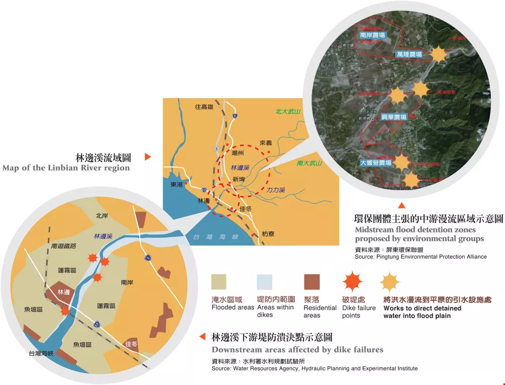
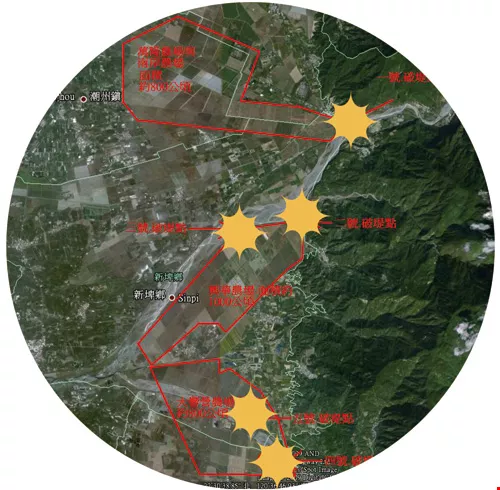
Map of the Linbian River region、Midstream flood detention zones proposed by environmental groups、Downstream areas affected by dike failures
To deal with the problem of water being too much for the dikes to handle, environmental groups hope that the midstream part of the Linbian River can go back to its original state as a "flood plain." Rather than spending huge sums of money on a manmade lake (as is currently planned), floodwater could be far more effectively and cheaply diverted into this broad, 3000-hectare reforestation area.
Is this really a fishpond? After the floodwaters of Morakot receded, 1000 hectares of fishponds in Linbian and Jiadong were left buried in mud, and today, two months after the event, still have not been cleaned out. One reason is that, since the soil is national property, only the township government has the right to remove it, but also some fish farmers want to take this chance to raise the overall level of the land to prevent future floods.


@List.jpg?w=522&h=410&mode=crop&format=webp&quality=80)


