There was a time when geographical knowledge meant little more than that heaven is round, and the earth square, formed from the body of the legendary giant Pan Ku, or that the sky is held up by tortoise feet while the land rests on a turtle's back. Only since the end of the 15th century, with Europe's great maritime expansion towards distant continents, did mankind begin to see the globe as we know it today.
It was the Portuguese who first made their way by sea to the Far East, and from the mid-16th century onwards their ships were frequent visitors. During such voyages, Portuguese mariners became familiar with the prospect of Taiwan's mountaintops amid the seas, and are said to have named it the Ilha Formosa, "Beautiful Island", from which it eventually became known in Europe as Formosa. According to Tsao Yung-ho, of the History Department at National Taiwan University, Taiwan's only authority on old European maps and a fluent speaker of Dutch, the earliest known western diagram of Taiwan is on a world map made in 1554 by Lopo Homen, a Portuguese cartographer. 'Fremosa' as he labels it, is placed off the east coast of southern China. That map, made from eight strips of sheepskin, is now held at the Museum of Archeaology in Florence.
In maps that followed, Taiwan sometimes comprised just one island, sometimes two, sometimes three, as well as coming in a variety of different shapes. Location was not fixed either. The Tropic of Cancer could pass fully to the south, or might bisect the southern or central island. The names it was given were variations on Formosa, or the Chinese name which included the island within the Ryukyu archipelago. As Tsao Yung-ho points out, maps of the day were largely compiled from collections of missionary reports, travel notes, and navigational charts, so that although short on accuracy, they can tell us much about what the Europeans knew of Taiwan.
Formosa became heard of in Europe before more than a tiny number of people had ever actually been there, and ever on the mainland the island was still barely known. Tsao believes this is probably because the steep mountains on the east coast, and the strong currents along the west, made landing tricky, while the natives had a distinct reputation for head-hunting. It was not a place you would want to approach unprepared.
At about the time the maritime powers were making links with the orient, the notion of China as a land of extraordinary riches began to spread. As one contemporary visitor reported: "This is a mighty, wealthy country, blessed with silk, gems, pearls, quicksilver, rhubarb, japonica, musk, and other treasures, in great abundance." Europeans were soon falling over one another in an effort to secure trade with China. The Dutch had joined the chase by the end of the 16th century, and needed a regional base. In 1622 they occupied the Pescadores, though claimed as Chinese territory. The Ming court ordered them driven off and let them settle on Taiwan instead. August 1624 brought the Dutch to the coast of the island at Tayuan (now Anping, in Tainan County) where they established themselves, building Fort Zeelandia, before turning their attentions inland.
The written record of Taiwan improves from that date, and the maps become more accurate, never again showing Taiwan as other than a single island after the 17th century. The most specific were the district maps, covering the southern coastal plain for instance, but with China trade the chief interest, Dutch maps for the most part concentrate on the mainland coast, the Pescadores, and the area around Tayuan.
The Chinese themselves saw Taiwan in a different light. The clearest Chinese map of the island from imperial times, is among the Huang-yu Chu'an-lan-t'u (Complete Charts of the Empire) finished under Kang Hsi in the Ching Dynasty. The emperor was in fact an enthusiast for geographical studies, notes Tunghai University associate history professor Hung Min-lin, in his work The Evolution of Taiwan Place-names. Kang Hsi once issued an edict containing the comment: "One has concerned oneself with geography since childhood." To conclude the massive task of the Complete Charts, the emperor, in the 53rd year of his reign, assigned three French missionaries skilled in cartographic surveying, plus a large team of assistants, to map Taiwan, by then fully under Chinese sovereignty. This was the first relatively scientific compilation of a map of the island, resulting in a highly accurate representation, although altitudes are not shown. However, the east coast is shown as blank, and the central highlands are simply indicated by painted peaks, because the sheer mountains, and fierce tribes of those regions meant that Ching rule was ineffective beyond the coastal plain to the west.
Prior to this, maps of the Ming Dynasty had tended to represent Taiwan solely in the style and brushwork of landscape painting: attractive, but lacking bearings, coordinates, or relative scale. Creative cartography of this kind, despite its shortcomings, managed to express something of the contemporary age and culture, unlike more modern maps. "The human element disappeared from maps once they were standardized," remarks Professor Shih Tien-fu of National Taiwan Normal University Geography Department. Nevertheless, Ching Dynasty maps retain artistic touches. In addition to natural features such as mountains, rivers and forests, the maps include scenes of junks on the estuary, town streets, little houses and villages. The Kang Hsi map even features tiny lifelike individuals, some empty-handed, some carrying loads, some leading an ox or driving a cart. There are farmers and livestock in the villages, and deer and hunters out on the plains, all providing an authentic picture of what life was like at the time. Another Ching map of Taiwan is one of the few imperial maps to use-longitude and latitude, albeit with latitude zeroed at the North Pole, and longitude measured in degrees east of Peking. The prime meridian passes through the observatory there rather than in Greenwich, which in Hung Min-lin's view makes plain where the Ching felt the center of the universe lay.
According to research by Hsia Li-ming associate professor at Taitung Normal College, there is a marked difference between Chinese imperial maps, produced to meet the political and military requirements of the court, and European navigation charts of the same period, where the commercial interest is foremost. Imperial maps were also kept hidden within the palace confines, usually in military hands, as precious documents.
Those early Taiwan maps which have survived, have found their way down to the museums and academic bodies of today, from the vaults of once all-powerful emperors, and the hands of daring sea captains. "They help researchers to build up a picture of early Taiwan," says Hsu Hsueh-chi, professor at Chengchi University. The Dutch maps have particular value to those researching early Taiwan history. Tsao Yung-ho adds that the differing place-names found on maps down the ages reveal something of the course of progress in Taiwan, as well as changes in the topography, and general level of geographical awareness at each time.
Shih Tien-fu and Hsia Li-ming have jointly put in two years of study on Ching Dynasty maps of the island, at the Taiwan Branch of the National Central Library. "In the absence of longitude and latitude, or any system of coordinates, it was customary at that time for the top of the map to face east, and the bottom west, with north and south to the left and right on a horizontal axis." Hsia explains that it is a method that works well for a bird's-eye view of Taiwan's western seaboard, lowlands in the foreground against a backdrop of mountains to the east. It also matches the perspective of Ching rulers in the heartlands of China, for whom Taiwan was a distant fringe.
These days the old maps are worth a small fortune. "The technique was to draw the outlines then do coloring. Some of those made by the Europeans featured elaborate decorative patterns, in baroque or rococo style, and are true old masters," says Tsao Yung-ho. The most costly Taiwan map handled by Mappamundi, a Belgian company that collects and deals in old charts from all over the world, went for over one and a half million NT, according to the company's Taiwan representative. Purchasers are mostly museums, libraries, academic societies, and government bodies, as well as a few private collectors. Some alert businesses have even found that by borrowing the aura of distinction carried by old maps, they can enhance their own corporate image. IBM is one such company in Taiwan. Their Mappamundi calendar featuring Taiwan map illustrations proved so popular with clients last year that they have arranged a follow-up for this year.
Feeling that the market is now right, Mappamundi has other publication plans. Maps and historical prints of the island collected from around the world during the last ten years, are being assembled for a book of early Taiwan history: The Authentic Story of Taiwan. It is an original but not unique undertaking. The results of the study on Ching maps at the Central Library are also being gathered for publication, with the first volume expected out this March.
In time, we will all know a little more of Taiwan's geography--more than just that it is shaped like a sweet potato.
[Picture Caption]
Map of Taiwan from the Chia-Ch'ing I-T'ung-Chih of the Ching Dynasty. At that time, government control did not reach to the eastern side of the island, so the map only shows the western seaboard and its islands. To the east is written: "Region of mountain savages." (photo courtesy of the Taiwan Branch of the National Central Library/ photo by Diago Chiu)
Early map of the Pescadores. Area, outline and position of each island a re all fairly inaccurate. (photo by Arthur Cheng)
Taiwan appears on this world map from the latter part of the seventeenth century, by Pieter Goos of Holland.
Taiwan as charted during the reign of Emperor K'ang Hsi, showing everything between present-day Taipei and Kaohsiung. (photo courtesy of Taiwan Provincial Museum)
Ching Dynasty map of China, by a Japanese cartographer. Taiwan is over-sized, and slightly misshapen. (photo by Arthur Cheng)
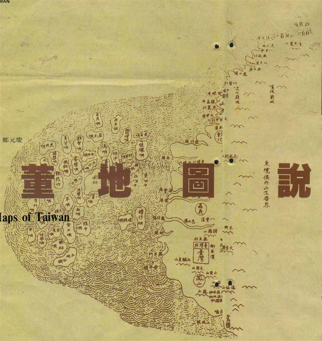
A Mappamundi employee holds one of her company's collection of early Taiwan maps. Chinese-made maps of the island tended to show it horizontally, which European made maps rarely did.
Map of Taiwan and part of the mainland coast, put together by a French cartographer.
A map of heaven and earth, giving some idea of early Chinese ideas about geography. (photo by Arthur Cheng)

Early map of the Pescadores. Area, outline and position of each island a re all fairly inaccurate. (photo by Arthur Cheng)

Taiwan appears on this world map from the latter part of the seventeenth century, by Pieter Goos of Holland.

Taiwan as charted during the reign of Emperor K'ang Hsi, showing everything between present-day Taipei and Kaohsiung. (photo courtesy of Taiwan Provincial Museum)
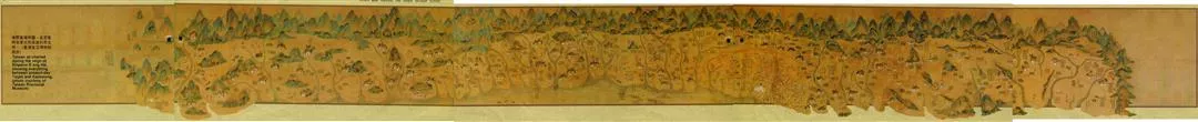
Taiwan as charted during the reign of Emperor K'ang Hsi, showing everything between present-day Taipei and Kaohsiung. (photo courtesy of Taiwan Provincial Museum)
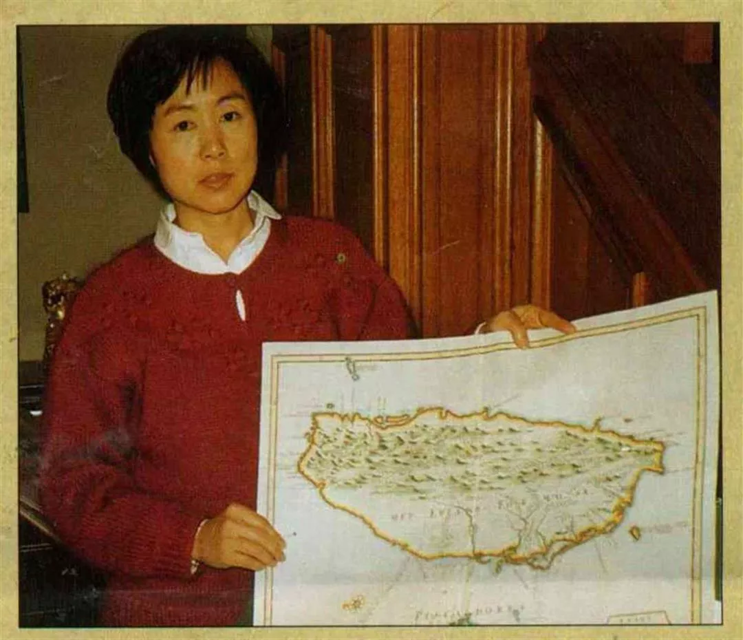
A Mappamundi employee holds one of her company's collection of early Taiwan maps. Chinese-made maps of the island tended to show it horizontally, which European made maps rarely did.
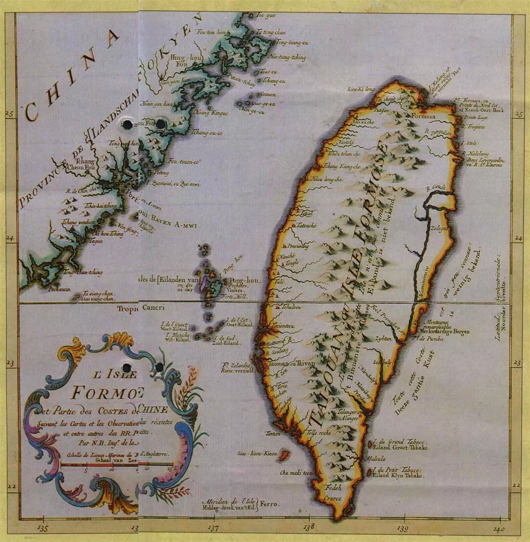
Map of Taiwan and part of the mainland coast, put together by a French cartographer.

A map of heaven and earth, giving some idea of early Chinese ideas about geography. (photo by Arthur Cheng)
@List.jpg?w=522&h=410&mode=crop&format=webp&quality=80)
@List.jpg?w=522&h=410&mode=crop&format=webp&quality=80)