Five major mountain ranges traverse the island of Taiwan from north to south. With over 250 peaks of 3,000 meters or higher, Taiwan has one of the densest concentrations of high peaks among all the islands of the world.
Inhabitants of earlier times opened up trails through the mountains for such purposes as commerce, social interaction, and military control. Today, these trails are more useful as leisure destinations. Serious hikers, in particular, are very fond of exploring along old trails.
High mountains and clear waters make for beautiful scenery and rich biodiversity. But the beauty is accompanied by danger, and serious hiking accidents are not unusual.
Just this past August, for example, came the shocking news that Lin Keh-hsiao, the president of Taishin Financial Holdings, had fallen to his death at a gorge in the mountains of Nan'ao, Yilan County. An avid and very experienced hiker, Lin had heard, while hiking along the Nan'ao Historic Trail, a moving legend about a local Atayal girl who had fallen to her death along an old trail in that area some 70 years before. He spent years looking for the old trail, and ended up writing a book-In Search of a Path-about his undertaking. How ironic, then, that he himself should die in the area where the legendary tale was set.
In his book (put out by Yuan-Liou Publishing), Lin wrote: "I decided to cut straight across the slope for a while, following an isocline, just to see what I might find. I had to use my machete to fight through the thorny brush. Every once in a while I'd run across a wall built of rocks, but it was hard to tell whether it was part of an old trail, or just the remains of some abandoned property line. Mostly what I found was silvergrass and rattan growing so thick that getting through it was like trying to cross the Maginot Line. Sometimes I did indeed see bits of abandoned trails. And sometimes it would take a half-hour just to make 10 meters of progress. It wasn't long before I was all cut up."
This quote gives an idea of just how much Lin loved forest trails, and how good he was at ferreting out long-lost paths. As Lin once said, he could "feel the mountains calling, and therefore kept moving forward."
"When I first heard that Lin had died," says author Liu Ka-shiang, "my enthusiasm for exploring old trails was very badly dampened. But I've been re-reading In Search of a Path recently, and have gradually been coming to grips with what happened to him. With all his many years of hiking experience, Lin was actually quite philosophical about life and death. He was very prepared for any eventuality."
Lin's fatal fall took place on a seldom traveled section of trail. Most people would have a hard time even getting there. And while Lin's fall was just an accident, the average hiker would be well advised to pay very close attention to safety. Before departing, it is necessary to familiarize oneself with the trail and prepare in advance to deal with emergencies.
This year is the centennial year of the Republic of China, and also the International Year of Forests, which the Council of Agriculture's Forestry Bureau is marking by completing a list of 100 recommended hiking trails located all over Taiwan, chosen for their special characteristics, be it mountain topography, beautiful atmospheric conditions, unique flora and fauna, sites of historic interest, or notable forests.
The Forestry Bureau has a five-level scheme for rating trail difficulty on the basis of topography, trail condition, facilities, and degree of danger. The easiest trails are classified as level one, while level five is reserved for the most difficult.
Level-one trails are relatively short, and are below 1,000 meters. It is easy to get to a level-one trail, and no special permit is required for entry. Slopes are not steep, a full range of facilities are available, and the trail surface is smooth and easy to walk in a hike lasting a half day to one full day. The Linmei Shipan Trail in Jiaoxi, Yilan County is a level-one trail appropriate for people of all ages.
Level-two trails are between 1,000 and 2,000 meters, and are easy to get to, but the hike can be a bit of challenge. Slopes may be steep, or there may be some difficult sections, but facilities are complete, the trail surface is smooth, and the hike can be completed in a single day. A good example of this level of trail is the Tefuye Trail in Ali-shan Township, Chiayi County.
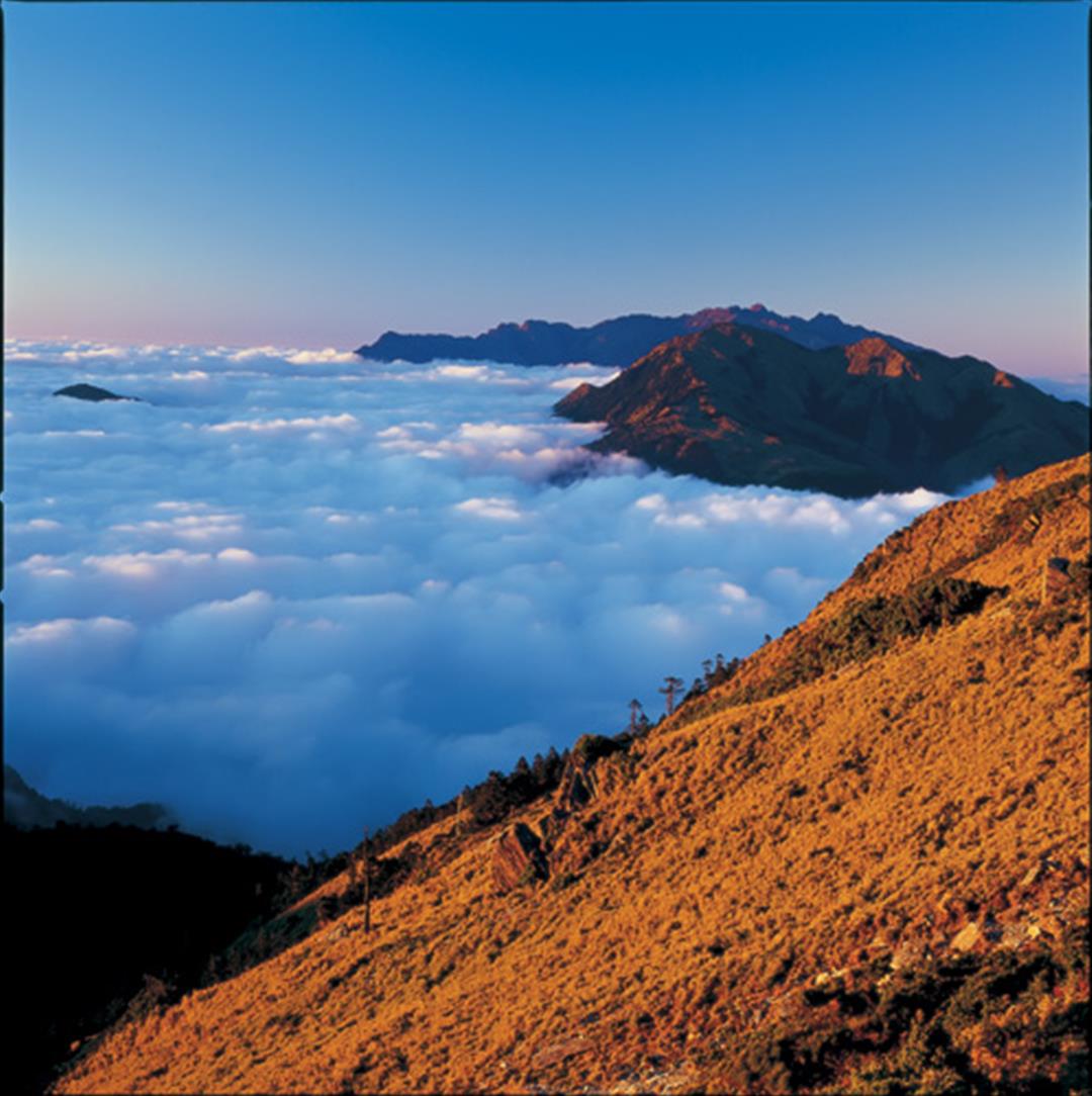
Level-three trails are between roughly 2,000 and 3,000 meters. Such trails can be rough in parts, and rather steep, but facilities are complete. They take from one to three days to hike, and are best attempted only by experienced hikers in good physical condition who have basic map reading ability. The Neng Gao Historic Trail, the flashpoint of the Wushe Incident depicted in the movie Seediq Bale, is classified as level three.
The Neng Gao Historic Trail was once used heavily by the Seediq people, who hunted the surrounding area, and has played an important role in Taiwan's economic development. Workers from the Taiwan Power Company used it in the 1950s to get through the forests and put up a high-voltage power transmission line across the Central Mountains. This is perhaps the most internationally famous of all Taiwan's mountain trails.
The typical level-four trail is above 3,000 meters. The walking surface is unimproved in any way, slopes can be quite steep, some sections are difficult or dangerous, weather conditions can change very dramatically, and it takes from one to three days to complete the hike. Hiking groups need to be accompanied by a professional guide, and the hikers need to be in good physical condition, be able to read maps, and possess survival skills. An example of a level-four hiking trail is the Jiaming Lake National Trail in Haiduan Township, Taitung County.
A level-five trail would be above 3,000 meters, and located inside a nature conservation area. The condition of the trail would be poor, without many improvements, and it would have many sections that are difficult or dangerous. Slopes would be steep, and the weather very changeable. A hike would generally take at least three days to complete, and a professional guide would be required. The Forestry Bureau has not yet opened any level-five trails.
Note that all trails from level three and up pass through nature conservation areas, which means that a mountain pass must be obtained in advance. The Forestry Bureau began in 2001 working on the nationwide trails system, and has either completed or is preparing 14 national trails, 14 regional trail systems, and 56 sub-regional trail systems.
To avoid tragic hiking accidents, the Forestry Bureau urges hikers to stay away from little-known routes and prepare carefully before heading into the mountains. In order to help readers both at home and abroad better understand all there is to see along Taiwan's hiking trails, we will be introducing a number of different trails in this series. Our trails are virtual poetry, left in the hills by the feet of our forebears.
Note: For more information on Taiwan's national trail system, go to the "Taiwan Forest Recreation" website:
http://recreation.forest.gov.tw.
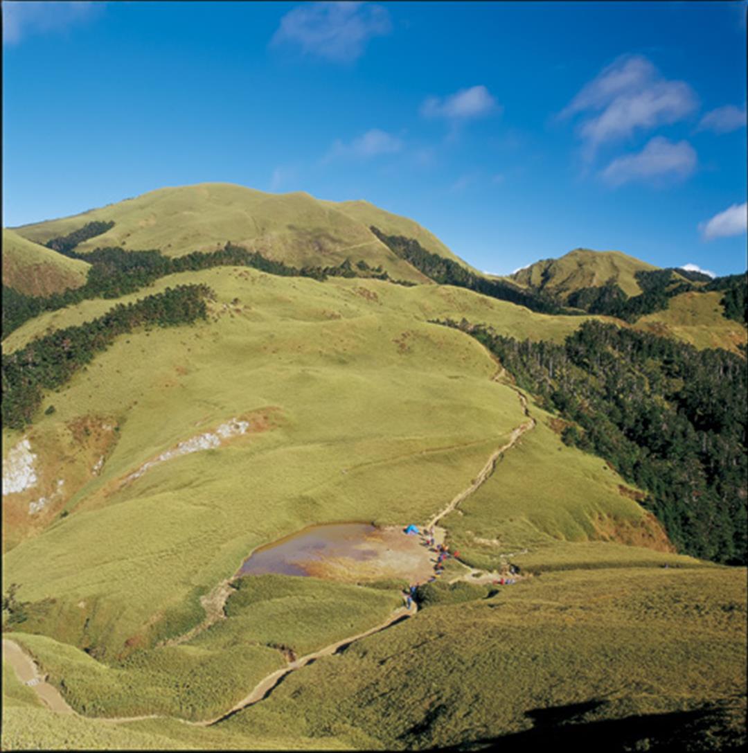
With over 250 peaks of 3,000 meters or higher, Taiwan's mountains feature a wide variety of climes and scenery, and are greatly beloved by hikers. Shown here is the South Peak of Qilai Mountain at the western endpoint of the Neng Gao Historic Trail, noted for "Sky Pond" and meadows covered with arrow bamboo.
@List.jpg?w=522&h=410&mode=crop&format=webp&quality=80)