Yuanpei is a small island in the Pescadores that was formerly just a quiet fishing village, but has lately become something of a tourist attraction. It owes its fame to the "path on the sea."
The 4.6 kilometer-long natural pathway crosses the sea from Shakang on Penghu Peninsula to Yuanpei itself. At high tide the trip across by boattakes ten minutes. When the waters retreat however, the waves seem to part, revealing a passable track to the island along a shoal.
Chen Shan, a 66-year-old resident of Yuanpei Village, explains that in the past the pathway was the islanders' transportation lifeline. "Small boats could not put to sea when the wind was up, leaving the island cut off. If an emergency arose the only way was to go across on the path." Chen's wife adds that once when their daughter was running a temperature, she had to carry her to Shakang on her back to find a doctor.
No one is certain when the pathway was discovered, and by whom, but Chen Shan remarks that his forebears knew of it once they had moved across to the island, and reckons that it must have been used for at least a hundred years.
These days there is relatively little need to use the pathway, with better boats making crossing by sea more convenient. Two years ago, therefore, Chen Shan's sons thought of putting the pathway to use for tourism, and began operating as guides, leading visitors across to the island at low tide.
According to Associate Professor Yuan Pi-te of the graduate school of marine geology at National Sun Yat-sen University, there are three conditions for the formation of subtidal shallows, as the phenomenon is known. It is necessary that the two places are linked by a broad stretch of level terrain that emerges from the water when the tide ebbs; there should be a large difference between high and low tides (the largest in the Pescadores is 3.3 meters); the coast must be rocky and firm, as sandy coastline can be shifted by the waters, making a fixed pathway difficult.
Another place where these conditions are met is the 19-kilometer-long path linking several small islands in the North Sea with Friesland in Holland. It takes six hours to walk and has become an international tourist attraction.
The Pescadores were originally a single mountain of basalt which eroded, sank and separated into a number of scattered islands. There are four island groups centered on the main island: the east sea, western islands, south sea and north sea groups. When the tide falls it is possible to walk from the main island to Yuanpei in the east sea group, and to Tatsang Island in Penghu Bay. Of the two, it is the walk out from Shakang to Yuanpei that is the longest and most enjoyable to make.
The delight of "walking on the waves" at Yuanpei comes partly from splashing through the water with a gentle breeze in the midst of a limitless expanse. But part of the attraction also lies in the variety of marine life on view. Associate Professor Wang Wei-hsien of the marine resources department at National Sun Yat-sen University has conducted research at Yuanpei, and says: "Such a large area of subtidal shallows is rare anywhere in the world. When the tide falls, marine organisms can be seen fully with your own eyes. It is a precious classroom of natural marine life, some forty varieties of which can be seen just on initial observation, and certainly more on close inspection."
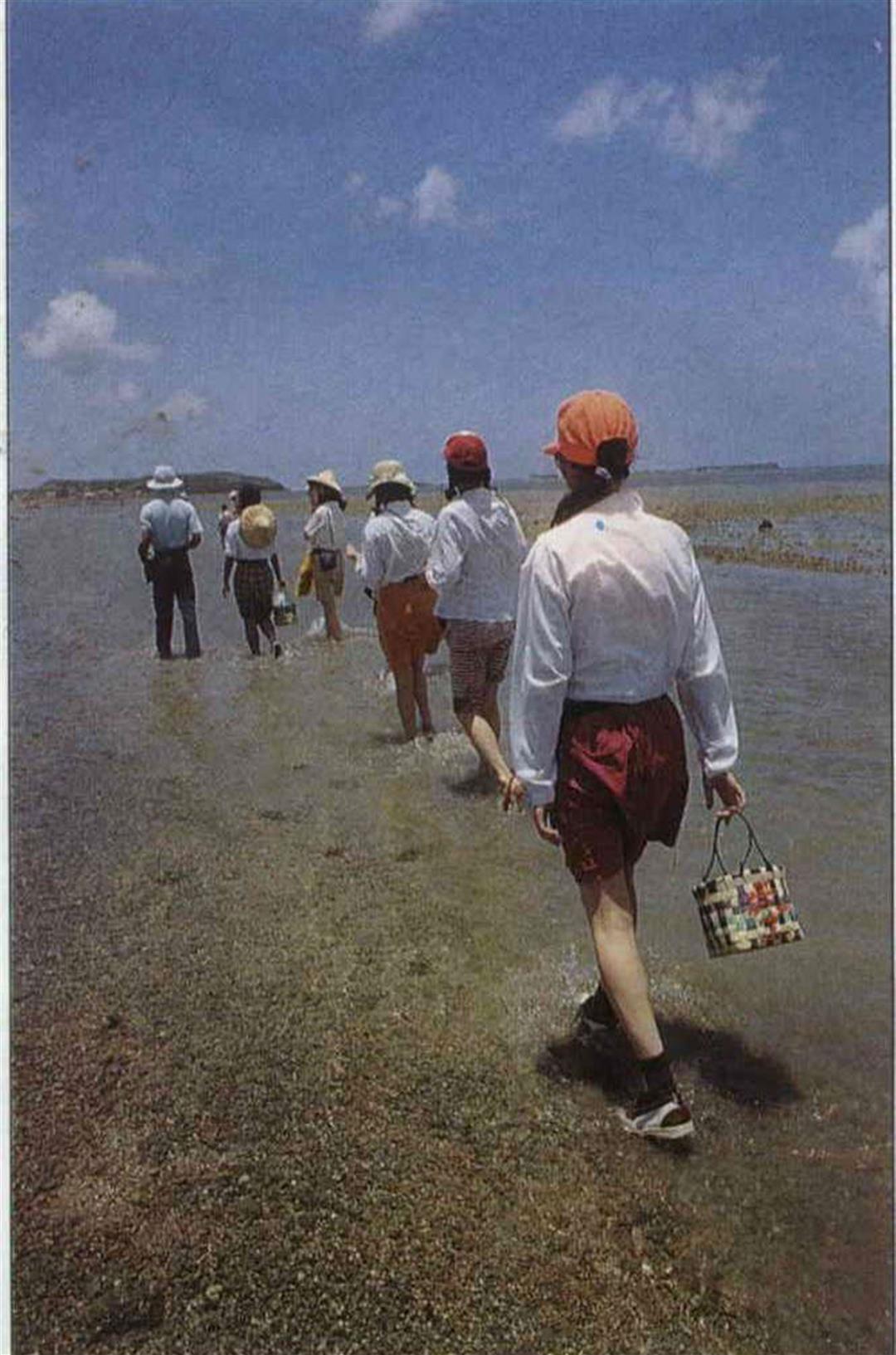
Wearing long sleeves and a hat against the sun, with shorts to plough through the water in, and rubber sneakers for comfort on the gravel pathway, and with bags sent ahead by boat, your intrepid reporter was dressed and ready for this in-depth travel report. Our guide for the trip across to Yuanpei was native-born Chen Shun-hsien, who has two years of experience and is thoroughly familiar with the terrain and marine life that are encountered along the way.
Setting out from Shakang, with Yuanpei barely visible in the hazy distance, one can't help wondering: "It's so far away, won't the tide come in when we're only halfway across?" Yuanpei villagers laugh at the suggestion. It takes them about an hour to make the journey, and although visitors spend much longer walking, the two or three hours that the tide is out is enough for anyone.
Says Chen Shun-hsien, the best times to cross are between the first and third, and sixteenth and eighteenth of the lunar month, when the sea is at its lowest. On those days the pathway can be crossed for about four hours, starting at two or three in the afternoon, and sea anemones and sea urchins are easier to see than at other times. The tide goes out fifty-five minutes later each day, so when it goes out at night it is not a good time to use the pathway.
After walking along a short stretch of gravel track we came to a sand bank, ankle-deep in water, with seaweed occasionally underfoot. At first there was no talking among the group of walkers. The only sound was the splash of feet on water, and it was even a little boring. Suddenly one of the group called out: "Look!" A school of small fish had just raced past our feet, though the rest of us missed it. Then some one else spotted some small crabs and eagerly pointed them out to their friends. In this way, stepping among fish and crabs for about forty minutes, we arrived at the midway "island"--in fact a large talismanic shihkantang, made of basalt rocks piled there by locals. At high tide it juts one meter from the water and can easily accommodate ten or twenty people on top. The shihkantang pacifies the winds, drives off demons, favors the fishermen with calm seas -- and doubles up as a convenient rest station along the way. "When necessary it can be climbed on to keep above the waves," says Chen Shun-hsien. Not far past the midway island is an area of coral, to the left of the path in water 30 - 40 centimeters deep. Coral of all different appearances can be seen here, some like flowers, some like twigs, and the wonder of it is that it is actually living.
Although you find yourself out in the middle of the sea at this point, far beyond reach of any shore, it is not scary because the water is generally only ankle deep, never reaching above the knee.
After the coral the pathway passes by an area of sea to the right where the water is a deeper shade of blue, and which the guide dubs "the deadly pool." A visitor once strayed into the pool and was lucky to be rescued by locals out harvesting sea gourds. In fact there are dangers all around, and you cannot afford to be careless.
From then on, the route was a succession of wonders. Small lumps of sand filled the water, some looking polished like a millstone, some frilled at the sides. What all had in common was the small hole at their center, with stepped edges. This was the "sand pagoda" that is home to the mudskipper. It builds its house of sand then burrows in through the hole in the middle.
Another frequent sight on the bottom through the clear sea water, is the black form of sea slugs adhering to stones. "Bamboo shoot of the sea "is a creature that buries itself half in the sand, with its shell partly exposed in the water, from which it occasionally emerges to feed. Many diminutive sea gourds dot the sandy floor. The bulbous globefish, its belly bulging and its body covered in raised spikes, warily eyes us as we pass on by.
Skirting Grass Island, we at last have Yuanpei fully in our view. Only then do we realize that we have been on the sea for over three hours, forgetting the merciless sun, the stones in our shoes and even the hunger in our bellies. At the end of the route, as everyone comes ashore and looks back, it is hard to believe that in a few more hours the road we have just trod will be completely submerged by sea. All felt the same hope that this pathway on the sea can always stay the same way, and not suffer any harm.
Notes:
Bed and board is available on Yuanpei Island at the Yuanpei Holiday Hostel. You can stay the night and spend the next day touring the east sea islands by hired boat. If you wish to return the same day that you arrive, a ten minute boat trip will take you to Chihkan.
With the summer vacation underway, and all the recent media publicity about Yuanpei, the number of visitors has increased and there are fears for the condition of the pathway. The administrative office of the Pescadores special scenic region is making arrangements for a special tour trail, and has set controls on vehicular and pedestrian traffic across the pathway. Vehicles of three or more wheels cannot now use it, and walkers have to apply to the local authority for permission, registering their time of crossing, the route, and the name of their guide.
[Picture Caption]
The water barely comes up to your ankles. It is hard to imagine that after a few hours this will all be sea.
(Right) A little rest means you can walk further. "Midway Island" made of piled basalt rock is the halfway rest station.
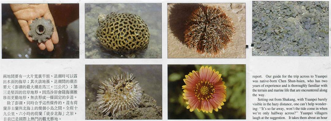
See what we discovered along the way! From let to right, top to bottom, the mudskipper's home in the sand; brain-shaped coral; sea urchin; seaweed; globefish; the tienjen chrysanthemum, which can be seen all over the Pescadores.
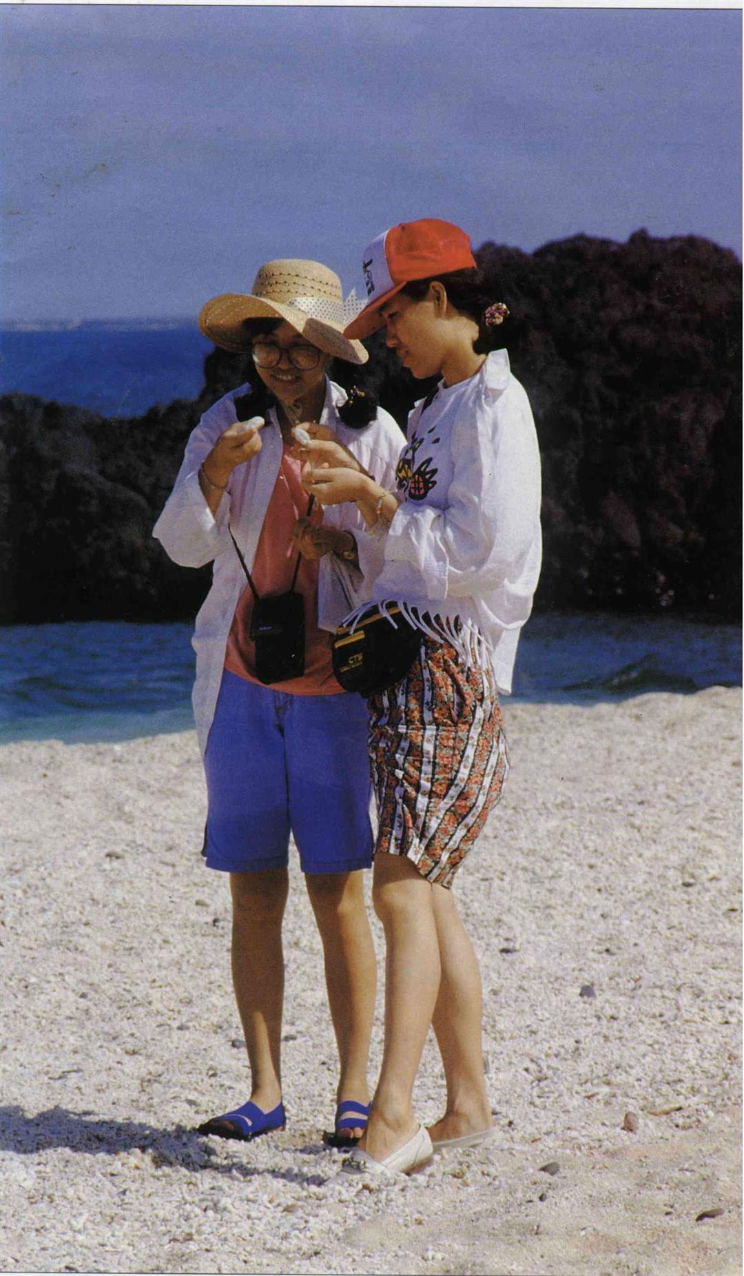
(Right) There are almost too many beautiful shells and white corals on the beaches of the Pescadores for the eye to take in. Once you have finished looking, you should put them back where they came from.
The original basalt terrain broke up in different ways, resulting in different scenery. The picture shows sloped basalt on Yuanpei Island.
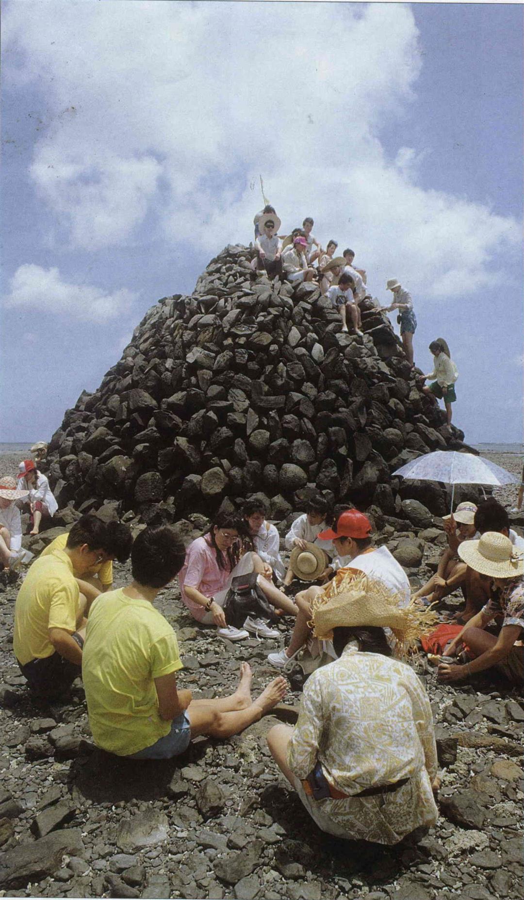
(Right) A little rest means you can walk further. "Midway Island" made of piled basalt rock is the halfway rest station.
See what we discovered along the way! From let to right, top to bottom, the mudskipper's home in the sand; brain-shaped coral; sea urchin; seaweed; globefish; the tienjen chrysanthemum, which can be seen all over the Pescadores.
(Right) There are almost too many beautiful shells and white corals on the beaches of the Pescadores for the eye to take in. Once you have finished looking, you should put them back where they came from.
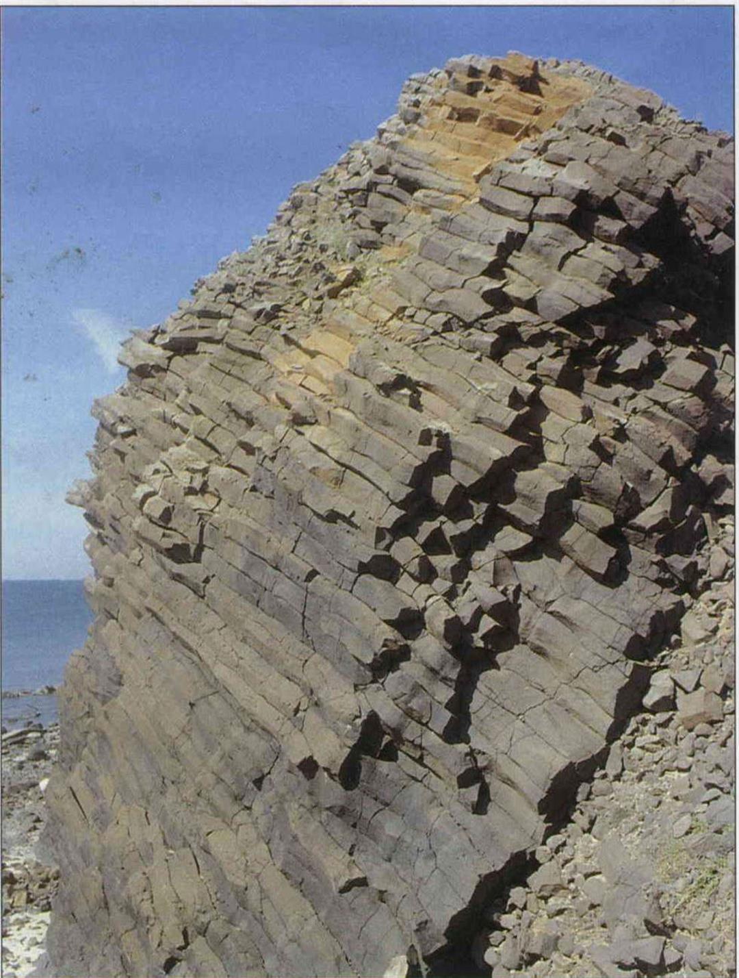
The original basalt terrain broke up in different ways, resulting in different scenery. The picture shows sloped basalt on Yuanpei Island.
@List.jpg?w=522&h=410&mode=crop&format=webp&quality=80)


@List.jpg?w=522&h=410&mode=crop&format=webp&quality=80)