What if there were no sea walls?
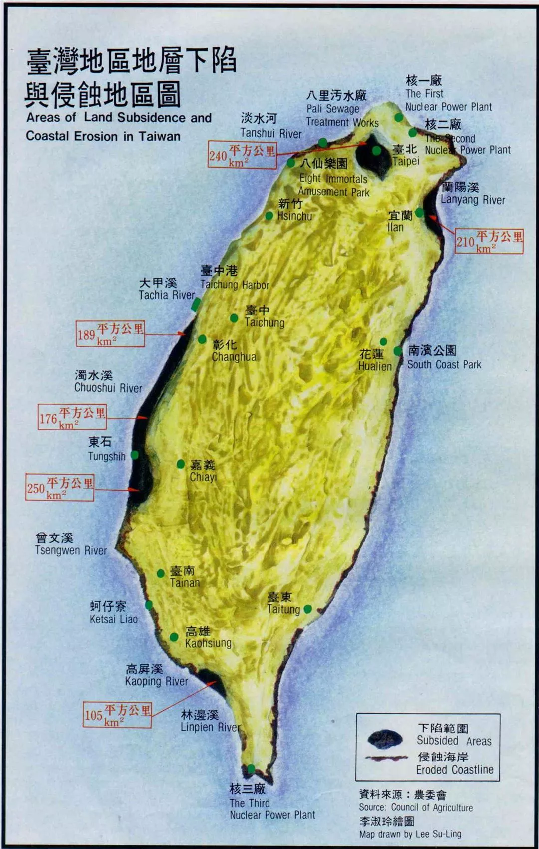
Surface subsidence has been caused by the aquaculture industry pumping out too much underground water. Taiwan's underground water resources are replenished at a rate of 4 billion cubic meters per year, but last year as much as 7 billion cubic meters was actually extracted, more than half of it pumped by illegal fish farms which pay neither water charges nor taxes.
"Furthermore, one third of all water extraction on the island is concentrated in strips of land within two kilometers of the coastline," Associate Professor Chou Nai-fang of Cheng Kung University points out in his report "Water Resource Development Prospects." Of these areas, those where the overextraction of underground water is most extreme are along the west coast from Changhua County to Chiayi County and in the south around Linpien in Pingtung County.
Surface subsidence is a major cause of coastal retreat. Kuo Chin-tung says that for every two centimeters by which the land subsides, the sea advances inland 30 centimeters. Since 1976, Pingtung has sunk by 2.54 meters, while Yunlin has sunk by 1.5 meters. Flat, low-lying Yunlin and Chiayi Counties are still subsiding by 20 centimeters every year. Their coastal areas have all sunk below sea level, creating "unlimited potential" for further land loss.
With the coast being eroded and land sinking, without the sea walls such areas would long ago have returned to the sea. According to Professor Hu Nien-tsu of Sun Yat-sen University, if the sea walls were removed, 1170 square kilometers of land in areas of excessive ground water extraction, equivalent to one tenth of Taiwan's flatlands, would go the way of Atlantis.
"But if you raise the sea walls by one meter, in five years they are under water again," says Lin Yung-teh of the Executive Yuan's Council of Agriculture. If it were only a matter of coastal erosion, then building sea walls could still slow the loss of land to the sea. But if the land subsides below sea level, then where tide levels are high, even if the land is surrounded by sea walls on three sides, water will still slowly seep through, and it is impossible to guarantee that the sea will not overtop the walls and flood in. Dealing with this kind of land loss is like a desperate fight with one's back to the wall, and not at all like the story in primary school textbooks where the little Dutch boy stops a hole in the dike with his finger, waits for a passerby to call help to mend it, and the whole village is saved.
My home has water all around:
Nowadays people building houses along the coast of Yunlin, Chiayi or Pingtung have to build in an allowance for future subsidence. One farmer who was once chosen as one of the country's "Ten Finest Young Farmers" likes to take people to his house to see the "marvelous undersea world." Going down into his cellar with a diving mask on, one can watch the fish swimming about between the wine cabinets.
By the time the symptoms of land subsidence appear, the disease is already beyond treatment. In the Kouhu and Ssuhu areas of Yunlin County, over 2000 hectares of land are submerged under the sea at high water, and only exposed at low tide: an area of land 3000 times the size of the Tokyo Dome "Big Egg" baseball stadium has become part of the intertidal zone, washed by the rising and falling tides; and there are 200 hectares in Hukou which are completely under water, not having broken the surface in the last five years. Although the submerged land is still surrounded by a useless sea wall, one can basically say that it has disappeared from the map.
Subsidence once provided a use for the China Steel Corporation's blast furnace slag, which was used as landfill in sunken areas, but the cost was horrendous, and it tied up large numbers of men and vehicles. Recently it has been suggested that if the Yunlin Litao Industrial Zone development really goes ahead, as the area lacks water, one need look no further than the region's own areas of subsidence, which could be dug out and used as artificial lakes to store water. This proposal has not so far been acted upon, but it would seem to make little difference whether one digs them out or not: haven't the subsided areas become "artificial lakes" already? It's just that like Lake Qinghai in mainland China, they are salt lakes!
Where land has subsided one can recognize past mistakes and try to make the best of the situation, but how can lost land be recovered?
The great period of land growth is over:
The book "The Authentic Story of Taiwan," published by scholars of Taiwanese history at the Academia Sinica, when describing the development of the island by the early immigrants, does not forget to mention that Taiwan's western coast is a plain formed by the accumulation of waterborne sand, mud and gravel, and that the coastal plain is still rising upwards.
But although this is true, measured against the fleeting timescale of a human lifetime, the rate is extremely slow. Kenting is rising by no more than 1 millimeter per year, so there is no way that the increase in area generated by this mountain-building process can keep pace with the loss of land caused by human activity. Land is hardly likely to suddenly burst from the ocean, and if it did the shock of such a sudden rise would be too much for its flora and fauna. Today geologists are also worried that additional extraneous factors of environmental change, such as the possible melting of glacial ice due to the greenhouse effect, leading to a worldwide rise in sea levels, may further exacerbate the problem, causing land to sink into the sea even faster.
The great period of "growth" for Taiwan's land area is over. "It has passed from the youthful stage of development into the mature period, and now artificial factors are pushing it towards premature old age," says Lin Yung-teh, explaining that even in the early period after Cheng Cheng-kung arrived in Taiwan, the clearing of land for farming, the quarrying and mining and the steps taken to control the wild rivers quickly began to affect the supply of silt downstream; however, the potential for creating environmental disasters was very limited compared with today's development.
Our land, surrounded as it is by the sea, depends for its existence on maintaining a dynamic equilibrium between the forces of the sea and the land. If today we make abrupt changes by such actions as building dams and extracting gravel, and thereby weaken be forces of the land, then the sea will gain the upper hand, and the land will be forced to beat a retreat. The vitality of the accretive coast, with new land constantly appearing, was an asset which other nations can only dream of, yet we are destroying it without a thought.
A new dam every year--a worrying prospect:
We seem to be caught between the devil and the deep blue sea. If we don't build reservoirs, with our unevenly distributed water resources and our dry autumns and winters, where is our drinking water to come from? If we don't mine gravel, how can our public works projects be completed? If we don't pump water from the ground, how will our people, who love seafood and need fish protein in their diet, be able to live happily? To live our modern lives, mustn't we make some unpleasant sacrifices?
Geologist Chang Shih-chiao, who twenty years ago questioned the wisdom of building the Tseng-wen Reservoir on the grounds that it would lead to coastal erosion downstream, says that we have been pushed onto the horns of this dilemma entirely by our own actions. In view of the difficulty of securing water resources, which gives us no choice but to build some reservoirs, one would think that we would be especially careful of those resources. But we all recklessly pollute the abundant water resources of the middle and lower reaches of our rivers, and wilfully build roads, sports grounds and so on in the water catchment areas of our reservoirs, thus shortening their lives so that we have to keep on building new ones. A reservoir only has a life of 40 to 50 years, and Taiwan only has some 40 remaining sites suitable for building new reservoirs. If we are to build a new one every year from now on, then 90 years from now all Taiwan's reservoirs will be silted up, and there will be nowhere left to build more.
Many countries today have recognized that reservoirs can be used sustainably, allowing dambuilding programs to be cut back. They also make long-term studies and measurements of how much silt a dam will hold back and what the results will be in terms of coastal erosion, in order to take preventive action such as adding supplementary silt downstream. Only in this way can one avoid the double loss caused by reservoirs becoming choked with silt and land being swept away.
Hsu Shih-hsiung cites Japan as an example: the Japanese long ago recognized the dangers of excessive gravel extraction; there was a period when they did not use their own gravel, but sent ships to carry from Hualien. Hsu says: "Its not that one can't extract gravel, build reservoirs or use ground water at all; its just that we have shown no restraint in the way we have taken gravel from the river and water from the ground, believing it is there for mankind to take willy-nilly."
The gifts of nature are not inexhaustible. The changing shape of Taiwan is demonstrating this only too eloquently.
A complete lack of coordination:
"Does it really take that much specialist knowledge to understand that taking gravel will affect the coast downriver?" asks Chang Shih-chiao. Because everyone assumes that some other agency downstream will sort things out, the agencies charged with managing water resources and building reservoirs do not worry about the coastline, while the Water Conservancy Bureau, which is responsible for the coast, simply spends money building sea walls. Because of the lack of tidal land on the east coast, the Regional Planning Commission opposes the development of new fish ponds on the Lanyang Plain, yet in recent years the number of fish ponds in Ilan County has been growing at the highest rate anywhere on the island. Everyone is working busily, but the left hand doesn't know what the right is doing, so in the end all their efforts come to nought, and the resources are just wasted.
For this reason no one is keeping count of just how much land has really been lost to the sea. Faced with such loss, we can only rely on the Water Conservancy Bureau spending hundreds of millions of NT dollars on repairing and strengthening the sea walls. Chang Shih-chiao worries that with so much money being spent on the breakwaters, if adequate funds are not available for just a few years, then we will be in big trouble.
The retreating coastline affects us all, whether in cities or hamlets, in agriculture or industry. But those who suffer first are the disadvantaged areas nearest the water's edge, such as the poor fishing villages of Tungshih, Putai or Chinhu. :”Unless land prices rocket and the speculators buy their way right to the edges of the island, no one's going to worry about the problem of coastal erosion," comments Wu Chuan-an bluntly.
Large-scale loss of land to the sea is something we may not see in our own lifetimes, and anyway we still have the chance to move inland. "Those who will suffer will be the later generations," says Chang Shih-chiao, adding thoughtfully: "Actually I think it may not take that long. It may not be more than a few years before we see all kinds of ill effects in places like Kaohsiung, Taichung Harbor and Hualien Harbor, or Ilan and Taipei."
What's a country without its land?
Listen to the tide ebb and flow, watch it rise and fall... At low tide along the coast of central Taiwan, the level mudflats stretch as far as the eye can see, and the visiting anglers walk far out to the water's edge to squat down and cast their lines. When they look behind them, the land is on the distant horizon. Formerly, the difference between high and low tide off Taichung Harbor was 4.6 meters, making it one of the best potential sites for tidal power generation in Taiwan, which has few natural resources. But now the coast of Taichung County has been washed away to form cliffs, and the gently-sloping beaches, the sandbanks, the dunes and the intertidal zone are all gone. At Taichung Harbor, only recently opened to visitors, "future children will be able to look at the port, but there will be no beach for them to play the sand," says Hwang Ching-her, chief of the Coastal Engineering Division at the Institute of Harbor and Marine Technology.
Today geologists no longer tell their joke about "national reunification." In their new joke, looking at the way the Industrial Development Bureau is rushing to invade the tidal lands and busily planning coastal industrial zones on paper, scholars wonder: "Do they really think Taiwan's tidal lands can be extended all the way to the mainland just at the stroke of a pen?"
[Picture Caption]
p.8
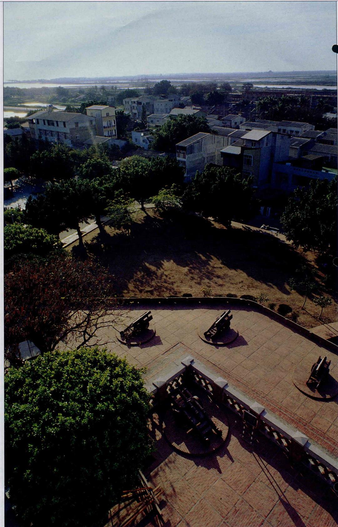
Western Taiwan used have one of the fastest rates of new land accretion anywhere. Fort Zeelandia, built on the coast in the days of the Ming Dynasty general Cheng Cheng-Kung, is now landlocked and stands within Tainan City itself. (photo by Cheng Yuan-ching)
p.9
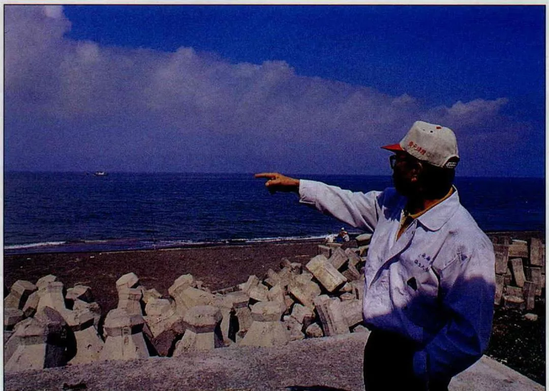
"My old house is under the sea," says the mayor of Chih-hsi village in Kaohsiung County, pointing out over the ocean. Because the land is being washed away, most of the villagers have moved out. (photo by Cheng Yuan-ching)
p.10
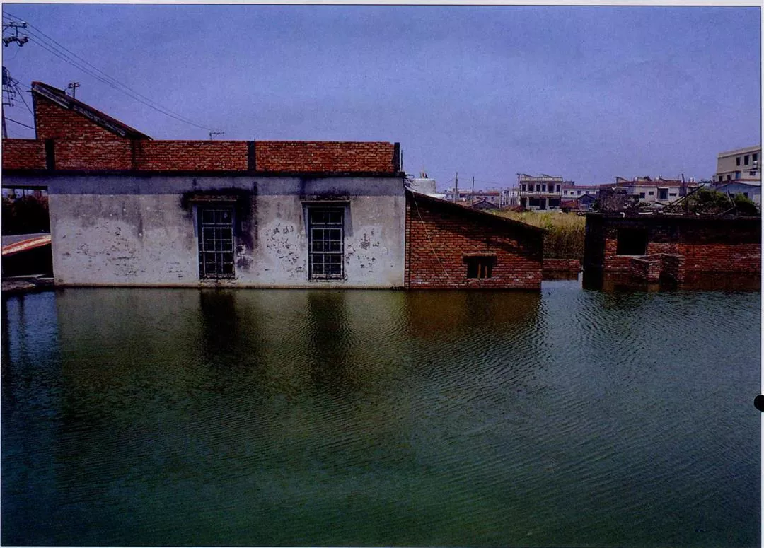
If the land sinks 2 cm, the shoreline may retreat 30 cm. Severe subsidence along Taiwan's coasts puts the land in danger of being engulfed by the sea. (photo by Cheng Yuan-ching)
p.12
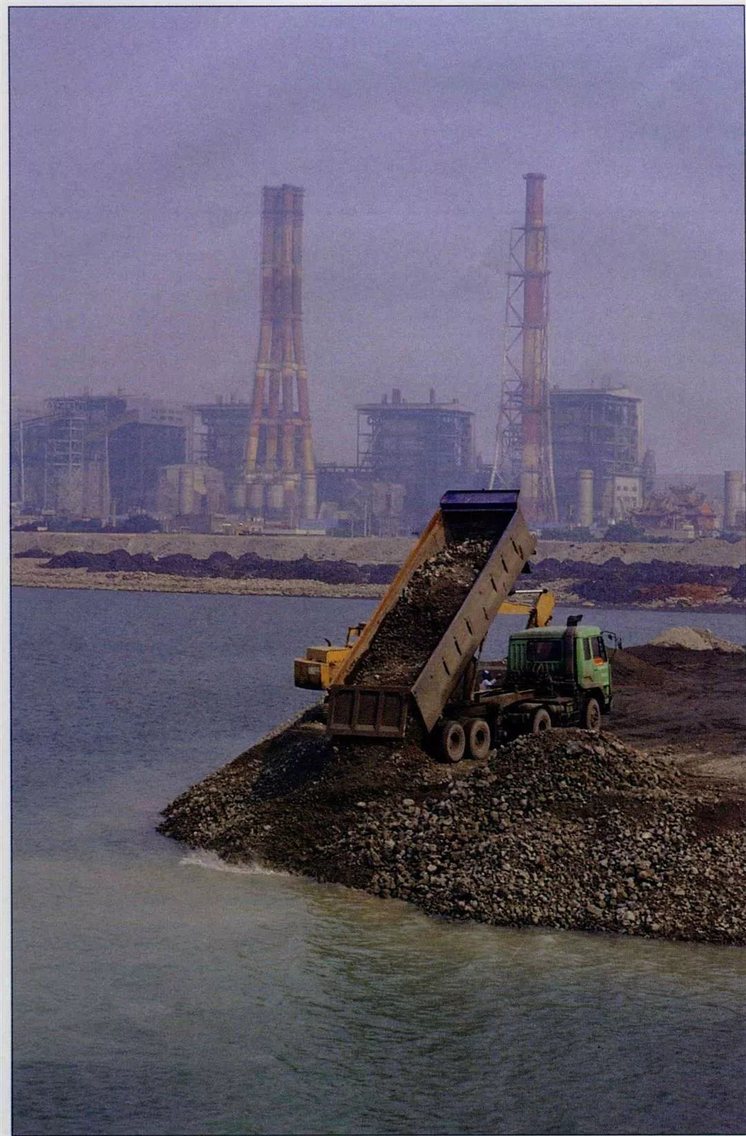
Taiwan is suffering continuous coastal erosion, and some have suggested that spoil from engineering projects can be used to reclaim land from the sea. But is this enough to slow the loss of land, let alone increase its area?
p.13
The shoreline at Pali on the south bank of the Tamshui River is receding too. In future when people from Taipei go to see the sunset at Tamshui, perhaps they won't have so far to go.
p.15
With coastal erosion changing the island's outline, will the next generation living on Taiwan still be called "yams"?
p.16
Seeing our country in all its beauty, can we help but wonder who makes the crashing tides flow and holds the land above the water?

@List.jpg?w=522&h=410&mode=crop&format=webp&quality=80)


@List.jpg?w=522&h=410&mode=crop&format=webp&quality=80)