To understand the importance of Taroko, it is necessary to start with a collision between two of the earth's gigantic tectonic plates. Six million years ago, the Philippine Sea Plate, which had already long been moving in the Pacific, smashed at an angle into the largest tectonic plate in the world, the Eurasian. Taiwan, located on the southeast edge of the Eurasian Plate, was consequently pushed up through the surface of the sea. Even today, Taiwan is rising at a rate of five to ten centimeters a year, making it the most "upwardly mobile" plate in the world, exceeding even Japan or the west coast of North America.
Interpreting the expression "world asset" broadly, the entire island of Taiwan would qualify based on the criteria of "being significantly representative of global evolution." Zooming in closer, Taroko Gorge is the represen-tative's representative.
Assets within assets
As noted above, Taiwan was pushed above the surface of the sea six million years ago. Thirty years ago, however, geologists discovered 200-million-year-old fossils in Taroko. It turns out that since ancient times rivers on the Eurasian continent have been dumping silt into the ocean, slowly creating the land bulge we now know as Taiwan. The earliest bit of Taiwan to rise above sea level was the eastern wing of the Central Mountain Range, specifically, the Taroko area.
In the course of Taroko's upward movement, intensive mountain-forming activity was churning up the soil underneath the surface. Sedimentary layers beneath the surface were continually pushed upward, compressed, and twisted by tectonic activity, and then were folded back under the surface. The high temperatures and pressure associated with such tectonic activity tempered the sedimentary rock into metamorphic rock. The world-famous marble from Taiwan's Hualien County, which is where Taroko Gorge is located, is an important example of metamorphic rock. This local natural asset that took geological forces 200 million years to sculpt, of which people in Hualien are duly proud, is now being resculpted by artists who are turning it into cultural assets.
Taroko is like a personification of Taiwan's geological history, carrying on her body the scars of a turbulent past. From an international point of view, Taroko represents the most recent mountain-forming activity in world geological history. Criteria for having natural sites listed as part of the World Heritage require that such sites record important transformations in the development of life or geology, or possess important features of a geological or topographical nature; Taroko clearly meets these requirements in many places.
Old and small
Pincered between tectonic plates, Hualien's Taroko tells the world of its splendour and beauty with its dramatic geography. Following the curve of northern Taiwan and taking the road into Ilan County and down the east coast of Taiwan, between the pounding waves and the cliffs, you reach a marble cliff face over 100 million years old. For millions of years the erosion caused by ocean waves has been at work here, carving out the Chingshui Cliff, an escarpment so sharply defined that it appears to have been shaped by a cleaver.
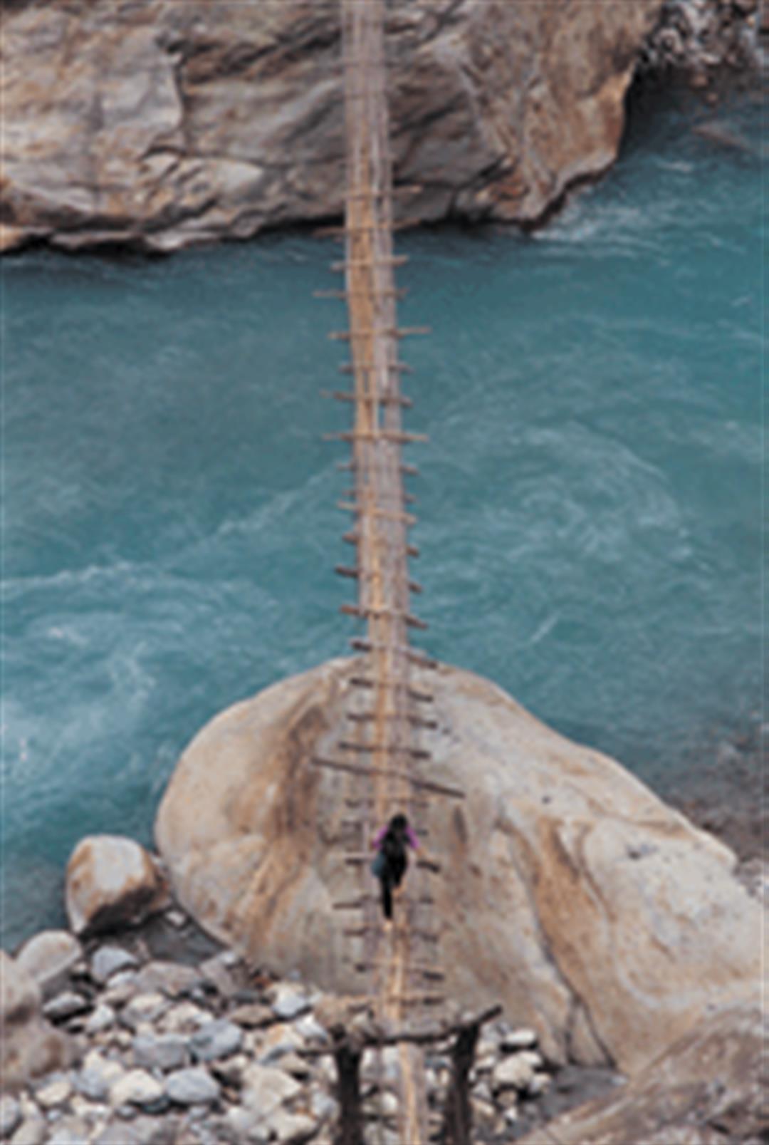
If you follow the Central Cross-Island Highway through Chinma Tunnel into Taroko you come to Nine Turns Tunnel and Big Cliff; this is the area commonly known as Taroko Gorge. River water has sliced a nearly 1000-meter deep crevice through the marble, and the result is a narrow U-shaped gorge with virtually vertical walls.
On the east edge of the Nine Turns Tunnel, rainwater has eroded the marble, creating a long and narrow cave. Gneiss, another type of metamorphic rock, is scattered along the sides of the creek. In particular, the stretch between Paisha Bridge and Swallows Grotto is an important location for observing and distinguishing between Taiwan's two oldest metamorphic rock types, gneiss and marble. By the way, at Swallows Grotto, visitors have to be careful that the objects they are carrying are not wafted into the clouds by the updrafts that come out of the gorge.
Scenically, Taroko Gorge is certainly not on the scale of the Grand Canyon in the United States. But it is nonetheless impressive how the motions of the earth's crust pushing upwards and the abundant rains and river waters cutting downwards have together magically carved this narrow 1000-meter-deep gorge, with its world-famous scenery.
Geologically speaking, explains Tsao Shuh-jong, section chief of the Division of Original Geology in the Central Geological Survey, "Taroko Gorge shows the clearest evidence of mountain-forming activity." In fact, everywhere in Taroko there is living testimony to geological forces.
In the Asia-Pacific region, only Taiwan and the Himalayas have been created by the "folding effect" caused by the collision between two tectonic plates. But in contrast with the Himalayas, where mountain-forming activity goes back 60 or 70 million years, the "precocious child" of Taroko Gorge is "in its infancy."
Since the 1970s large numbers of geologists from the US, France, and other countries have been participating in survey work in the Taroko area. "In other countries mountain-forming activity is mainly in the later stages, and it is impossible to see it in earlier stages. Since Taroko is a living example of the early history of geological evolution, it is useful for comparison with areas in the later stages of mountain-forming, so we can explore the relationships between the earlier and later stages and explain the evolutionary processes of geological history," says Tsao Shuh-jong. This is why Taroko Gorge is a "geological paradise" for international geologists.
Peak performance
Standing behind the internationally renowned gorge is the hinterland of the Taroko National Park, which occupies 120,000 hectares. Thanks to mountain-forming activity, the park is dominated by rising and falling peaks, with nearly one-sixth of the surface area at an altitude of 3000 meters or more. The area includes no less than 27 of Taiwan's 100 highest summits. The Chilai Ridge Line, which marks the northern end of the mountain range, is crisscrossed with perilous gorges and cliffs, and the weather is unpredictable, accounting for its infamy as "Black Chilai" among mountain climbers.
Taroko is even more important as a habitat nurturing biodiversity. While all the mountains are based on the same plate, their peaks are sharply separated. From the point of view of the area's biological significance, this has the effect of creating separate ecological zones, with the result being the evolution of many unique species and rich biological variety. There are 167 high-altitude plant species on just Mt. Nanhu, where winter lasts four months, accounting for a large proportion of such species in Taiwan.
According to preliminary surveys, half of all the mammal species in Taiwan can be found within the park, while there are also 144 species of birds, 32 of reptiles, 18 of fresh water fish, 28 of butterflies. . . . In terms of biodiversity, then, Taroko is home to many unique species. The map prepared by Wang Shin of National Taiwan University's Department of Geography for the World Heritage Site application includes the entire Taroko National Park.
The preparatory report also points out that Taroko's fabulous scenery has long been a well known attraction in Taiwan, attracting countless visitors year in and year out. The rich mineral deposits, meanwhile, mean that there are several mining sites in the area, creating serious destruction to the scenery. "The preparatory report not only must describe the conditions making a place a world asset, it must also point out the shortcomings, and methods to improve the situation," says Wang Shin. If Taroko really means to make it into the World Heritage category, the problem of mining must be resolved. If it is, we can say even more loudly that as a world asset, "Taroko certainly makes the grade!"
@List.jpg?w=522&h=410&mode=crop&format=webp&quality=80)


@List.jpg?w=522&h=410&mode=crop&format=webp&quality=80)