There is a Chinese proverb that warns, "there is a deity watching from three feet over your head." Science seems to be aiming for much the same thing with satellites. In a recently popular spy film, an intelligence satellite finds the camp of an international terrorist group. This "Eye of Heaven" also puts technology to the task of monitoring the earth beneath our feet.
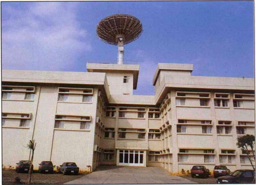
At National Central University, when you see the enormous satellite dish on the roof, you know you've reached the Center for Space and Remote Sensing Research (CSRSR). Each day at about 11:00 am, the dish slowly revolves, prepared to receive information from a passing satellite.
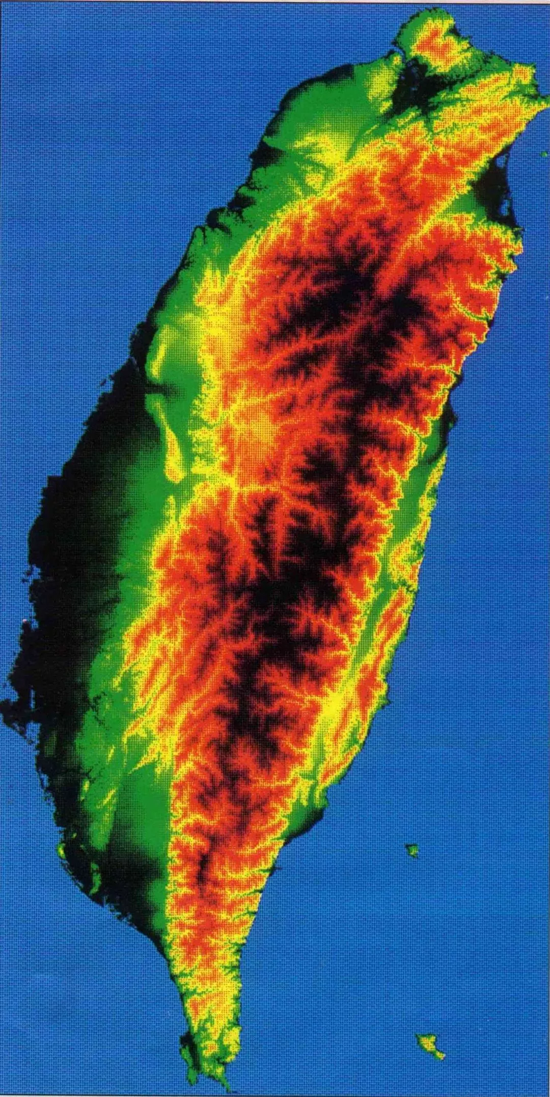
"Three, two, one, begin receiving transmission!" In the laboratory, we excitedly watch as a satellite image of Taiwan--our beautiful island seen as if from a cloud--unfolds on the monitor screen in splashes of red, yellow, brown, and green. It reminds us that part of the thrill of flight is this sensation that "the mountains and rivers of this great earth are all within view."
Meanwhile, placid personnel off to the side carry out the routine tasks they do every day. The transmission lasts only a few minutes--now the real work begins. The raw image recorded on magnetic tape must be fed into the computer to undergo a series of refinements. "Noise" (interference) must be filtered out and the image clarified before it can become the satellite image that the layman gets to see. How can we interpret these images and put them to good use?
Not a very clear picture
The satellites suspended in space like moveable stars can be subsumed under five general categories. The type most directly connected to daily life is the weather satellite, which provides maps of cloud cover to help predict the weather. Then there are communications satellites, which are the weapons with which the current television and media battle is being fought. Science satellites, meanwhile, are for space research. Fourth, we have the spy satellites, used for intelligence and national defense tasks.
Compared to these, the fifth type--resource satellites--is perhaps not so well known to the general public. These satellites evolved from technology declassified from spy satellites. The first resource satellite, Landsat I, was launched in 1972 by the United States; it's main responsibility was to track American grain production. In addition, its ability to monitor the Soviet grain harvest and Australian sheep and cattle farming startled the world. There are currently more than 10 such satellites in space tracking all kinds of changes on the earth's surface and serving as global monitors.
Although most people do not have a very clear picture of remote sensing technology, the information it provides is intimately related to our lives. The satellite images may well look colorful and engaging, but, when interpreted, as often as not they are warning signals. Overexploitation of slope land, river pollution, and many other problems are revealed in satellite images. Remote sensing can even do police work. For example, there has recently been great controversy over golf courses which have impinged on public or protected land; these transgressions were discovered from satellite images.
I will be watching you
In 1994, the Construction and Planning Administration (CPA) of the Ministry of the Interior began inspecting several golf courses in the area of protected water resource areas. "If you tried to do an on-site inspection and compare to a map, it would be difficult to verify the exact area and scope, and surveying would be hard to do," explains Kuo Nien-hsiung, director of comprehensive planning at the CPA. But because most golf courses far exceed their authorized area, it has been easy to see this from satellite images.
Information from satellites was treated through the geographic information system (commonly known as "electronic mapping") and then the extent of the completed golf course was compared to the original construction plan. It was thus confirmed that many operators brought their courses through a "metamorphosis," encroaching on public lands and thus building far larger courses than authorized. Though for the time being nothing is being done to alter the courses already completed, at least future operators might be a little more careful. In fact, comparisons of images show that courses still under construction are increasingly adhering to their original plans. "Probably the course operators can feel the government watching them," laughs Kuo.
In fact, the CPA purchases images from the CSRSR of slope and flat land for all of Taiwan as a tool to monitor ongoing construction of all types. "By building up a long-term data bank, we can get a better grip on trends in regional planning and national land use. For example, we can trace changes in land use, or keep an eye on changes in the coastline brought about by development of coastal areas," Kuo says. No wonder many people have nicknamed the CPA program "the Eye of Heaven."
Environmental surveyor extraordinaire
Remote sensing is already being used in environmental surveys. For example, it is helping to understand the black-faced spoonbill, an endangered species with only about 500 or so left in the entire world. Why are large numbers of them attracted to the Chiku area of Tainan to pass the winter? Are there other areas in Taiwan that have the potential to serve the same functions? Lee Pei-fen, an associate professor of zoology at National Taiwan University, has been attempting to answer such questions with the help of satellite images.
He first collated satellite images and on-site observations of the Wild Bird Society. After computer analysis, he found that the spoonbills congregate in one area at the mouth of the river when resting, but that they scatter over a wide area to feed from fish ponds. It is natural that the carnivorous spoonbills would hang around concentrations of fish, but "why do they concentrate at the mouth of the river to rest?" Pointing to a satellite image, Lee suggests: "It's because there are dikes around the mouth of the river, as well as lines of tree to block the wind." He used satellite images to calculate that the average distance between their feeding place and resting place is 3.16 kilometers. "This figure will be an important basis for mapping out the conservation area," he notes.
The above are just two examples of how satellite images can be put to use. Last September the CSRSR held the first-ever conference in Taiwan on utilization of resource satellites. Users presented 17 papers covering engineering, geology, land use, forestry, slopeland development, coastal land management, urban planning, research in the South China Sea, and overseas development. There are more than 70 programs currently being conducted.
"Satellite images are increasingly widespread in Taiwan for two reasons," explains CSRSR director Chen Liang-chien. For one thing, the quality of the images themselves and techniques for processing them have continually improved. Secondly, rapid changes in society have created a need for these images. "Taiwan's land surface profile is changing faster than probably any other place in the world, yet we don't have enough dynamic data on these changes. With satellite images, we can monitor these changes more efficiently and protect the environment better."
Environmental crime buster
For example, Taiwan's urban areas have been relentlessly expanding, putting great pressure on surrounding slopeland. There is a great deal of illegal development and overexploitation. Unfortunately, because there is so much slopeland to cover, it is often impossible to find out what is going on in time to stop it. Also, there are too few inspectors, and they are subject to appeals to friendship, backdoor political pressures, or bribery. However, resource satellite technology is impervious to such temptations, and can immediately uncover any dubious development.
Another example is monitoring of changes in forested areas. Keeping up with destructive exploitation or natural disasters (like forest fires) by using traditional survey techniques is time-consuming yet not timely, because of the huge extent and frequent inaccessibility of forested land (which is often concentrated in remote mountain areas with no roads). Satellite surveys, on the other hand, cover huge areas and can be collected regularly, making them an invaluable tool.
Over the past decade or so, the Taiwan Forestry Research Institute has continually employed satellite imaging and remote sensing to investigate changes in forested land, do resource surveys, and monitor the ecology. Vice director-general Cheng Hsi-chuan says that "in the past when judging lumber supply, we had to do ground surveys of the area of forested land, and then judge total volume by weighing samples of the different types of trees. But now, through remote sensing, we can easily measure the forested area, and, if clarity is high enough, We can even distinguish different varieties, making the job much easier."
In water resource surveys, water volume, flow, and the concentration of pollutants are generally observed by taking samples. Satellite images can complement such work by collecting a large amount of data covering a huge area all at once, greatly increasing efficiency.
Not a panacea
A resource satellite gets its advantage from height: It looks down from 800 kilometers above the earth, and can survey a large area with great efficiency. It can also capture a series of images over time to trace changes on a particular piece of the earth, as for example in studying the erosion of land along a coastline.
But a resource satellite has a severe weakness: Limited resolution means that it is impossible to see every detail. Many researchers emphasize that satellite imagery is very helpful as a tool, but it is no panacea. Thus, while it can easily discover suspect behavior on the earth's surface, a thorough scrutiny of the area in question would also require aerial photographs or on-site investigation.
Yet these images remain very useful. When used together with other techniques, such as digital analysis, the images can be overlaid to get a color image of even higher resolution, which can be used in many ways.
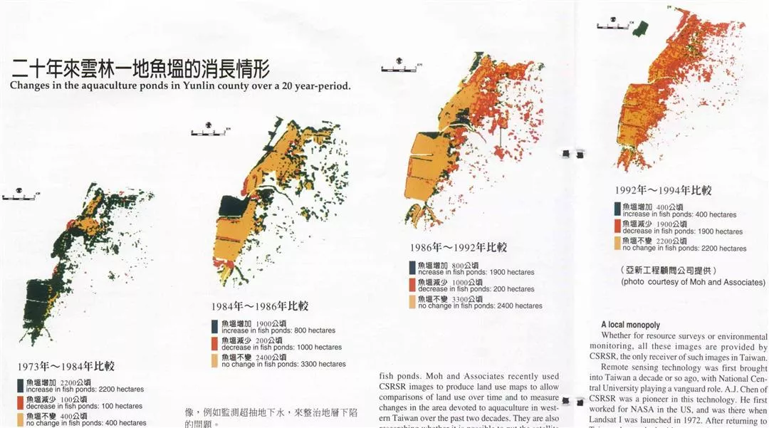
Over the past 20 years, there has been severe land subsidence (sinking) in coastal areas of southwestern Taiwan. This has led to many problems, including flooding after heavy rains, salination of underground water, and loss of land to the sea. There have even been people in Pingtung who have built the foundations of their houses to a meter or more above ground level, so that the houses will be at just about the right level when, as they anticipate, the land under the foundations eventually collapses.
The main reason for the subsidence has been excessive drawing of ground water by aquaculture pond operators. Therefore, in analyzing this problem, it is crucial to know the land area devoted to fish ponds. Moh and Associates recently used CSRSR images to produce land use maps to allow comparisons of land use over time and to measure changes in the area devoted to aquaculture in western Taiwan over the past two decades. They are also researching whether it is possible to put the satellite images to further uses, such as monitoring drawing of ground water, in order to solve the subsidence problem.
Like a human eye
You may very well be curious to know how a resource satellite can "see" surface data in the first place. "As the name suggests, remote sensing technology indirectly touches objects. It can find and sense objects from an enormous distance," relates Chen Liang-chien. "There is an optical sensing device on the resource satellite. Like the human eye, it records objects' reflection and absorption of light. This record is then sent to the surface where it is turned into images."
It's just that in the final analysis the satellite and the human eye are very different. When we see a satellite image, we must adapt our thought processes to interpret it. Taking the French satellite SPOT for example, it senses three light wavelengths: green, red, and near infra-red. Bare earth and mud-brick buildings strongly reflect all three wavelengths, often showing a grey-white color. Water, on the other hand, strongly absorbs all three colors, so it appears as black in the satellite image. Meanwhile, verdant land comes out in red (because, generally speaking, vegetation most strongly reflects near infra-red light), while cities appear in green. It is hard to get your brain to adjust to such seemingly mismatched hues.
A local monopoly
Whether for resource surveys or environmental monitoring, all these images are provided by CSRSR, the only receiver of such images in Taiwan.
Remote sensing technology was first brought into Taiwan a decade or so ago, with National Central University playing a vanguard role. A.J. Chen of CSRSR was a pioneer in this technology. He first worked for NASA in the US, and was there when Landsat I was launched in 1972. After returning to Taiwan, he worked with some other academics to promote applied remote sensing technology.
National Central University set up CSRSR in 1984 to cooperate with the Council of Agriculture's aerial survey unit to undertake research into remote sensing. At that time Taiwan had no receiving station of its own, and had to buy satellite data from the US or France. Moreover, image processing systems were not as widely available then as they are now. As A.J. Chen recalls, "At that time there was only one image processing system in Taiwan, and it was very expensive. It was placed in our center, but was open for use by all research units in the country. Our own researchers often had to wait until late afternoon or evening just to use it."
Three-in-one receiving station
In 1990, the CSRSR was commissioned by the National Science Council to set up the nation's first satellite data receiving station, to be called the "Satellite Remote Sensing Laboratory." Work was completed in June of 1993, allowing Taiwan to directly receive images from Landsat, SPOT, and the European satellite ERS-1. The area covered extends in a radius of 3000 kilometers from the center at Chungli. Images can be received of areas as far north as Hokkaido in Japan, as far south as the South China Sea, and westward to Gansu in mainland China.
At present there are 19 receiving stations in various countries, including the US, France, Canada, Japan, Korea, Indonesia, the PRC, and Singapore. Taiwan's station has been up and running for less than three years, so it is really the new kid on the block. However, for this reason it has the latest technology, and is special in many ways. For example, the sensitivity of its satellite dish antenna is among the highest in the world. Also, it is one of the few places in the world that combines receiving, image processing, and applied research in a three-in-one package. Chen Liang-chien suggests this may be because "we are one of the few receiving stations set up in an academic institution." Chen adds that Taiwan is first in the world in production of "standard images" (raw images processed into usable product). If users need more, the images are sent to another laboratory on the second floor for additional processing into "special products."
For example, the images can be further analyzed using the "geographic information system." In the above-mentioned cases of the golf courses, the black-faced spoonbill, and the fish ponds, information systems were used to help out. Using the "global positioning system," the location of anything on the surface can be pinpointed with accuracy without the need for further human measurement.
By overlaying images taken from two different angles, it is possible to differentiate altitudes of the topography, and then produce a "digital topographical model." From this, contoured images giving the impression of three dimensions can be produced. By calculating the steepness of the slope, these images can be used as the basis for assessing slopeland development. By calculating where the ridge lines are, watershed areas can be identified. By identifying valleys, the images can be helpful to mapping out water catchment areas.
But all of this is not cheap. The expression "time is money" is very appropriate for CSRSR. One second of satellite data time, during which the satellite travels seven kilometers, costs NT$1000! Annual expenditures at the Center, mainly subsidized by the National Science Council, total NT$100 million. Because remote sensing is an "applied technology," the Center is trying hard to "market" its products; right now the cost is only one-third that of the world market, and last year CSRSR earned NT$17 million, fourth highest in the world.
Especially challenging in Taiwan
"Remote sensing is especially difficult in Taiwan," notes Chen Liang-chien. As noted above, satellite remote sensing is best suited to measurement over large areas. In the US, for example, residential and agricultural areas are clearly separate, and huge areas of agricultural land are often devoted to a single crop, so it is easy to differentiate the objects in the satellite image.
Taiwan, in contrast, has a fragmented and complex topography, and land use is intricate and intensive. Often many different crops are planted in a single small area; small towns and large urban areas are not clearly defined and often are mixed together; and there are rapid changes in construction. These make it difficult to interpret satellite images.
The light spectrum of a resource satellite is inherently limited. It can only distinguish ten or so different categories of objects from the surface. Yet there are countless objects, and if two things react similarly to the same wavelength of light, the satellite may just lead to confusion. For example, beaches and urban concrete share the common main ingredient of sand, and sometimes they will show similar spectrum reflections. To a satellite, fallow rice paddy and aquaculture ponds can often look the same.
When satellite images were used to survey urban development in the Tanshui area, Lin Feng-tien, a professor in the Institute of Building and Planning at National Taiwan University, at first found that over the past six years the amount of land devoted to non-urban use had increased. In this era of real estate speculation and rampant development, this was a very unexpected result. But after on-site investigation, he discovered that the satellite read golf courses as land covered in vegetation. "This is a problem of interpretation. Sometimes on-site inspection is also required," concludes Lin.
Eye on high, treasure below
Remote sensing is a comprehensive technology bridging many disciplines; it requires teamwork and cooperation. Specialists in all areas are putting their heads together to figure out how to better use these images.
"The main limitation to satellite images right now is that they are too expensive, and they are still not precise enough. Nevertheless, they will still be increasingly used in big construction projects, and this will become a trend," says Chin Chung-tien, manager of the Geotechnical Engineering Department at Moh and Associates. In the future, high-level decision makers will be able to do instant checks on the progress of infrastructure projects just by tying the satellite images into a computer network.
Chen Liang-chien hopes that in the long run the use of satellite remote sensing will spread to city and county governments, and become part of the day-to-day routine at the basic level. Also, universities could offer classes in remote sensing and geographic information systems, and there could even be professional training.
Satellite technology is changing constantly. Israel plans to put up a commercial satellite this year which will be five times as precise as the best existing satellite, nearly as clear as a spy satellite. Taiwan has already signed up to receive images. Also, several private corporations in the US will soon enter the satellite market. It looks like terrestrial competition is about to be extended to space. Whoever can control the Eye of Heaven will have a leg up on everybody else.
The "vision" of satellites is constantly improving, as is our ability to put the images to good use. But will this information that we receive from miles above our heads cause us to treasure a bit more this earth beneath our feet?
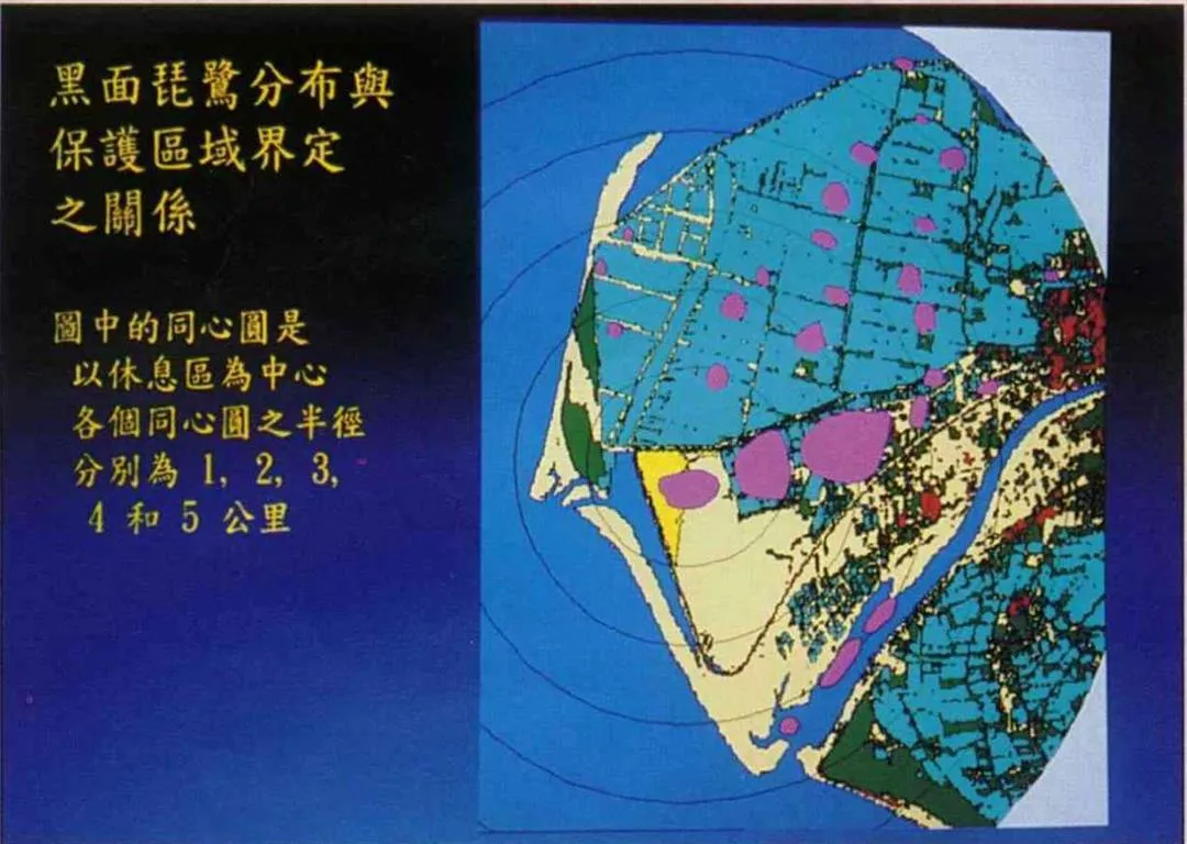
This is a satellite image, processed with a geographic information syste m, of the Chiku area. You can see that the main resting area of the black-faced sp oonbills (pink spots) is at the mouth of the river (yellow) inside the dike, whil e their feeding areas focus on aquaculture ponds (sky blue). (photo courtesy of Lee Pei- fen)
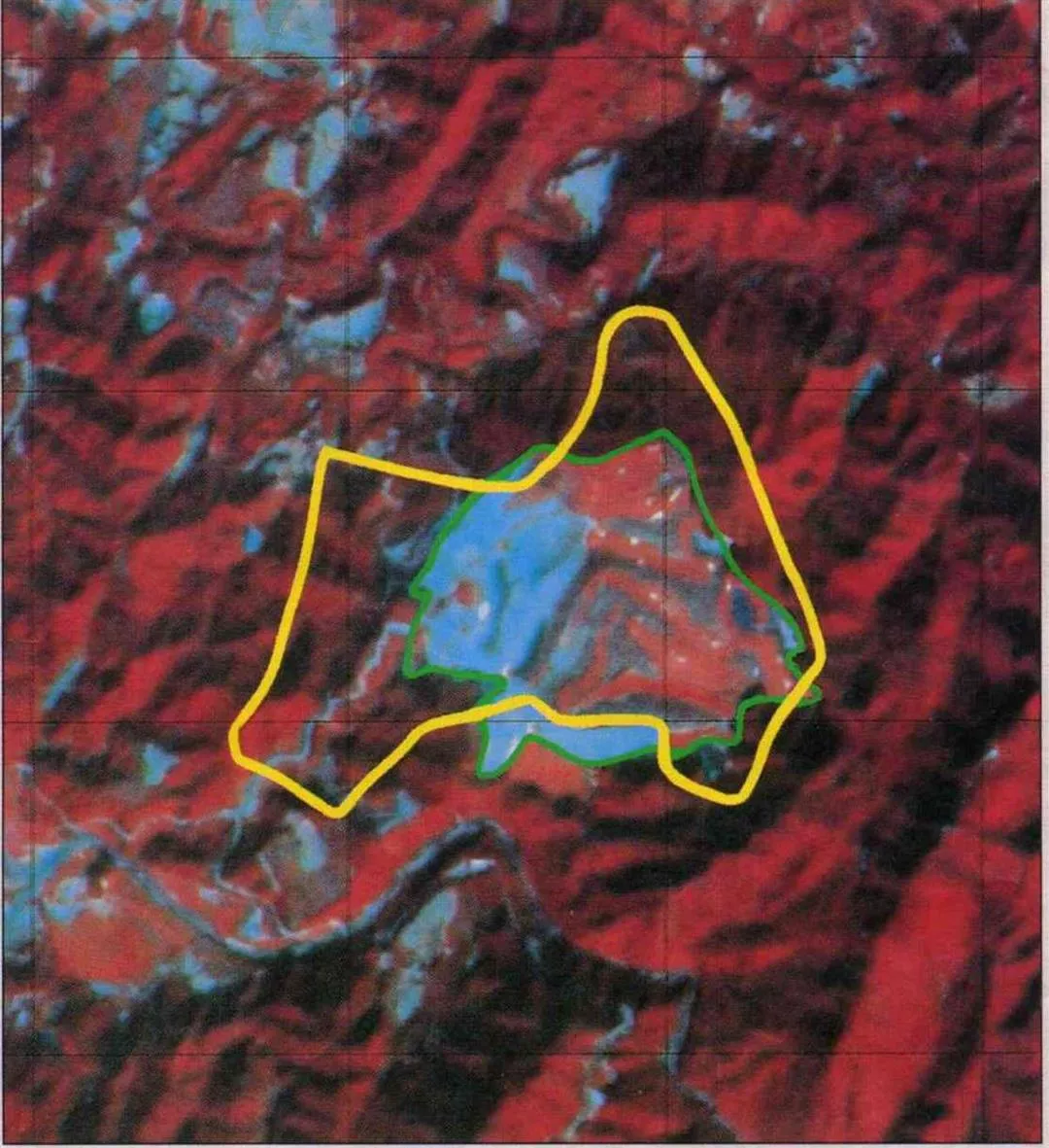
Wow! That's way off course! With satellite imaging, the out-of-bounds de velopment of golf courses is clear to see. The yellow line delimits the area for which the developer applied, but the land actually cleared extends to the green line. (courtesy of Construction and Planning Adminstration)
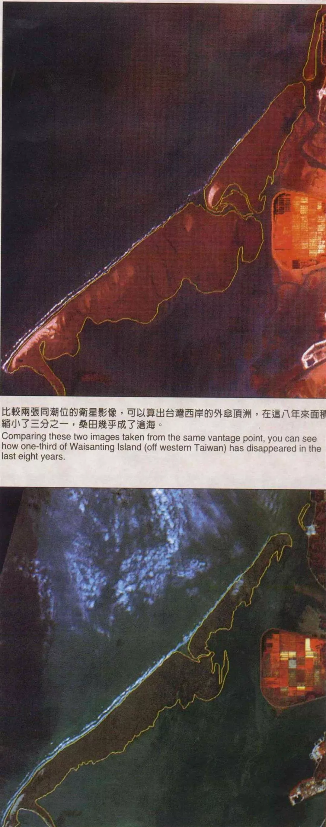
Comparing these two images taken from the same vantage point, you can se e how one-third of Waisanting Island (off western Taiwan) has disappeared in the last eight years.
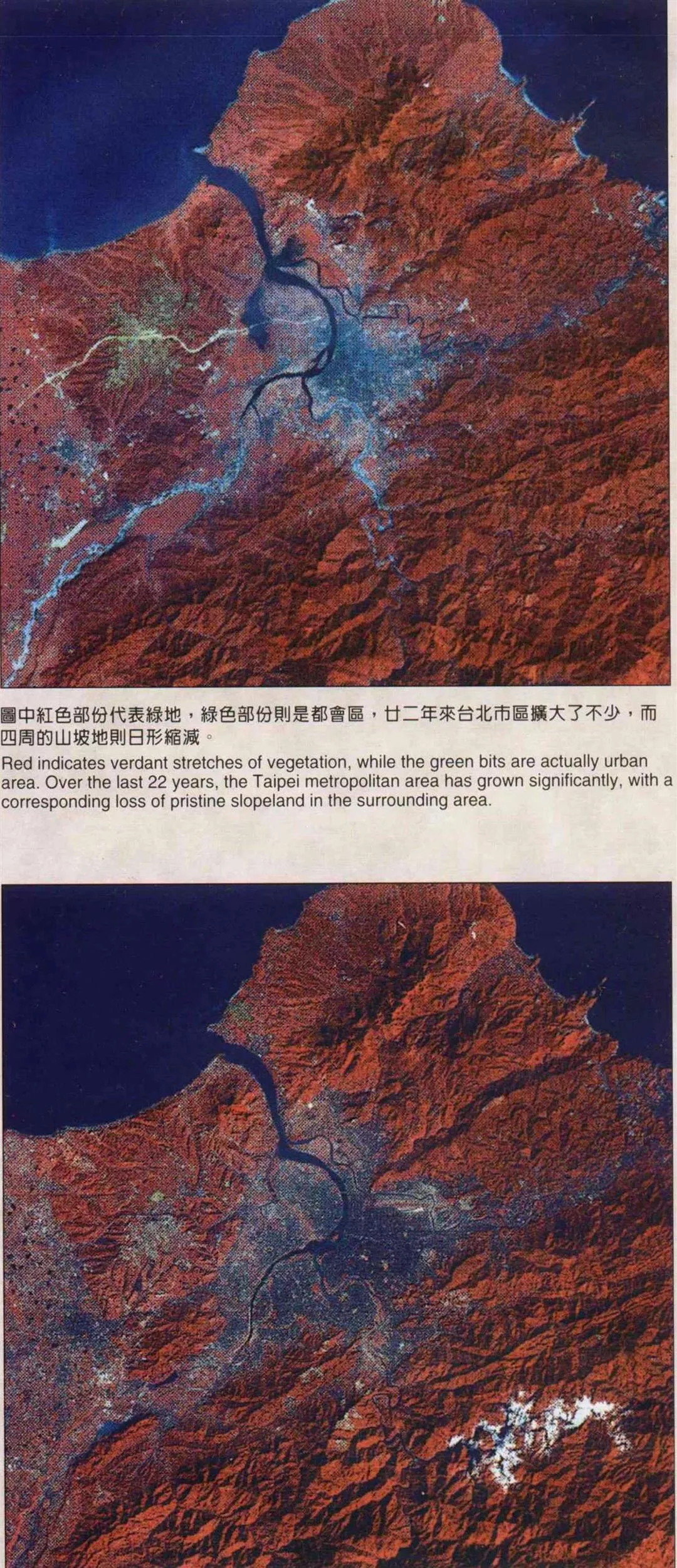
Red indicates verdant stretches of vegetation, while the green bits are actually urban area. Over the last 22 years, the Taipei metropolitan area has grown sig nificantly, with a corresponding loss of pristine slopeland in the surrounding area.Changes in the aquaculture ponds in Yunlin County over a 20 year-period.[Picture].