
For years, scholars have called for rezoning and other non-invasive steps in severely subsided coastal areas to solve flooding problems once and for all, but to no avail.
This year, however, the Executive Yuan passed a budget for the plan it ratified last year for demonstration zones for drainage and environmental remediation schemes in severely subsided areas, with parts of Dongshi and Xinwen in Chiayi as well as Yiwu in Yunlin designated as demonstration zones. Following the devastation caused by Typhoon Morakot, parts of Linbian in Pingtung may also be included. It would seem that things are now moving ahead. What is the plan really all about? Let's take a look.
The Chiayi plan covers the coastal area west of Provincial Highway 19 between the Beigang River to the north and the Bazhang River to the south, a total of 250 square kilometers (25,000 hectares). Thirty percent of that, the area west of Provincial Highway 17, is lower than the mean high water point. That means that any day the tides could turn much of this land into ocean were there no sea walls standing in the way.
The planning organization, the Taiwan Water and Environment Technology Research and Development Education Foundation, selected the open expanses of Dongshi and Xinwen as demonstration zones in which to conduct land testing and consultation with residents.
Foundation member You Jinyu explains, using the Dongshi demonstration zone as an example: The area of 1,000 hectares encompasses eight villages, including Wengang and Xingcuo, and is home to around 11,000 residents. Intersected by the West Coast Expressway and Provincial Highway 17, the land has been used for farming, fisheries, settlements, and graveyards.
The proposed "living with nature" model contrasts with traditional methods of building walls and installing pumping stations to contain floodwaters. Rather, it creates more space for floodwaters by returning some low-elevation areas to nature. The floodwaters will have a place to run off, and changes will be made to local industries to adapt them to the environment.
More concretely, the method is to classify the land in the demonstration zones into four categories according to their elevation. From highest to lowest, they are: Living zones, flood buffer zones, variable containment zones, and regularly submerged zones.
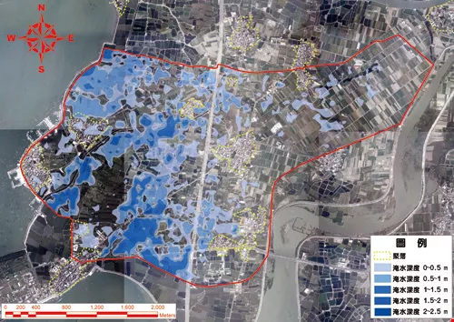
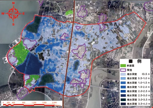
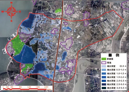
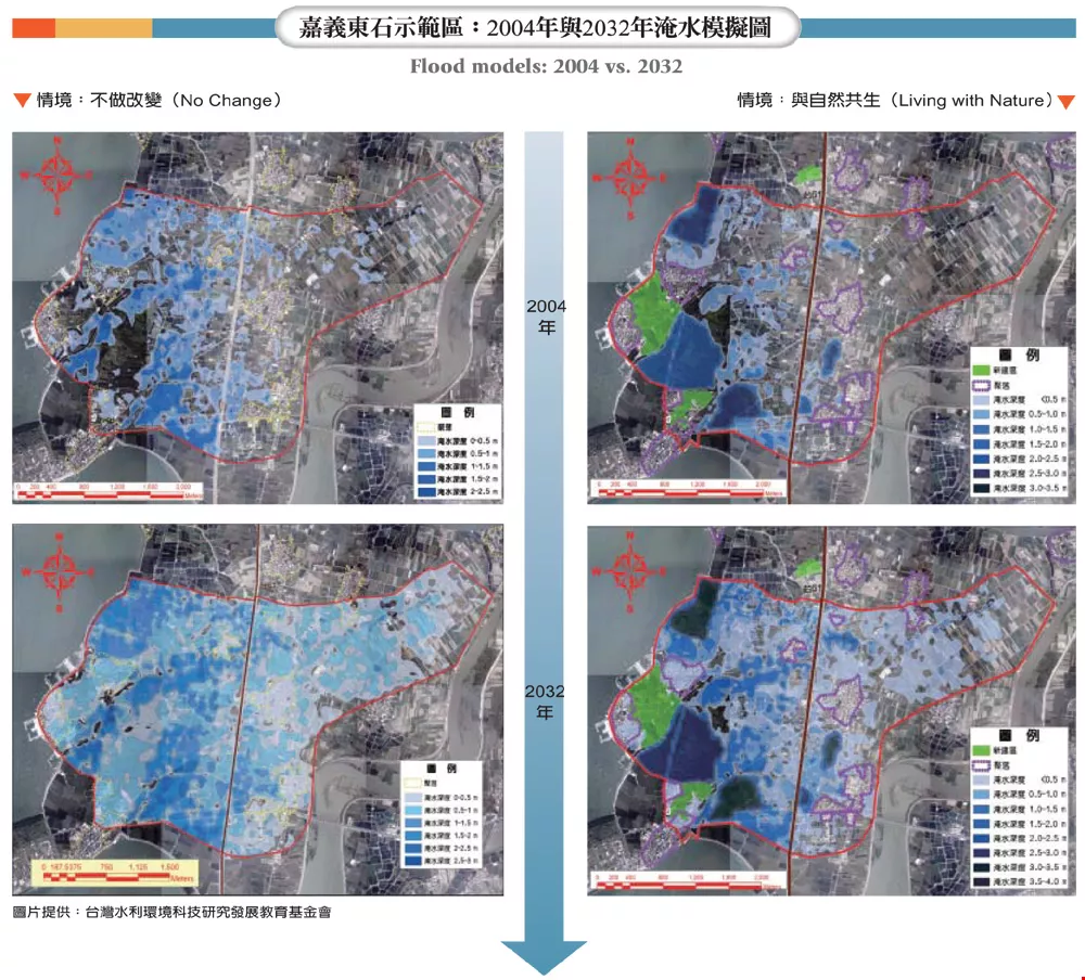
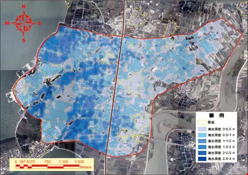
Flood models: 2004 vs. 2032
Living with nature
You explains that the lowest land, the regularly submerged zones, will be turned into large manmade lakes that can serve as reservoirs during flooding. The variable containment zones are broadly defined as being submerged, with the depths of their waters varying with rainfall. These are typically adjacent to regularly submerged zones and will remain in a state similar to wetland parks. Seen in a cutaway view, it looks like a large bowl with a smaller one-the manmade lake-placed inside of it. This way, when water floods over, the amassed water is naturally cleansed as it passes through the wetlands. It becomes groundwater usable for agriculture and aquaculture. This zone also will include a newly developed "ecological aquaculture" area, in which low-lying fisheries will be turned into aquaculture facilities that would not be harmed by flooding, such as ones raising clams or aquatic plants.
The third category, flood buffer zones, are areas that, years after having groundwater pumped out, are still slowly sinking. There is still less chance of flooding than in the second category, but it can happen in heavy rains. This category of land will be used as community parks and leisure space. It can also be used for agriculture and aquaculture businesses that are able to function even with the water there. The fourth category, the living zones, are for residences, roads, institutional and educational facilities, and the like. They also accommodate high-end aquaculture and agriculture businesses.
In order to avoid pumping groundwater, amassed floodwater will be used for aquaculture. The amount of surface area used for aquaculture is determined by the greatest amount of water that is accumulated, so that resources are used according to the capacity of the environment.
To zone the area in this way, public lands-originally 22% of the area-would have to make up 32%, or 100 hectares, of it in order to accommodate the manmade lakes, the runoff wetlands, and the public facilities. That means that some fisheries have to scale back their sizes and some residents have to give up land. On the other hand, the rezoning will feature newly zoned and reclaimed business and residential districts that should raise property values. The government will exchange such lands for residents' lands or provide compensation in order to preserve residents' existing legal rights.
"Even where residents have to move, their lives won't actually change much. That's why there isn't much resistance," says You. As for areas where private businesses are to be turned into low-risk aquaculture zones or returned to a natural state, in the future they might be suitable for new leisure or environmental education industries. Many residents are very accepting, but of course there are some who are worried or are unwilling to change and still need to see successful cases to put their faith in.
Flood models: 2004 vs. 2032
Simulated flood imagery
"We simulated three situations using four time periods," explains You. The first was 2004, the "status quo" year. Next were the years 2013, 2019, and 2032. Flooding under three situations-doing nothing, using traditional methods, and using the new "living with nature" plan-were shown (see Figure 1) assuming current rates of subsidence and climate change. They used a formula to calculate flood areas, and with traditional means of water control, flooded land would leap from 4,500 hectares in the status-quo year to 12,000 hectares in 2032.
Researchers overlaid Google satellite images with the results of the simulations to allow residents to see first-hand what the future would hold for their farms, fisheries, and homes. This eased communications. After more than a year of interactive discussions, residents basically approved of the "living with nature" model of water control and environmental restoration.
The reclamation, public facilities, flood control, adjustments in business operations, and environmental restoration in the Dongshi demonstration zone will take an estimated four to five years, at a total cost of around NT$3.3 billion. If the entire 250-square-kilometer area in Chiayi is rezoned in this way, the estimated cost will be roughly NT$16 billion.
The director of the plan for the Chiayi coastal demonstration zones, Professor Li Hongyuan of National Taiwan University's Department of Civil Engineering, says that aquaculture in the Chiayi coastal area brings in around NT$4 billion a year but the government has spent more than NT$25 billion managing the area in recent years. In comparison, by spending NT$16 billion, all of the area's problems with subsidence and flooding could be solved and at the same time living standards and property values would rise and new business opportunities would be created. Which is the more effective solution? The question hardly needs to be asked.
Zhuangzi tells the story of one Lady Li who was married off to Duke Xian of Jin. She cried until her tears soaked the collar of her robe. But after spending some time in Jin, she discovered that her life there was much more comfortable than it had been at home. She had to laugh-what had she been so sad about?
It's the same for residents of low-lying southwestern coastal areas who've suffered enough from floods. If the government can really provide land for them that is environmentally safe and allows for a good lifestyle, what is there to worry about?
Flood models: 2004 vs. 2032
Flood models: 2004 vs. 2032
Flood models: 2004 vs. 2032


@List.jpg?w=522&h=410&mode=crop&format=webp&quality=80)


