An Ecological Corridor for the Danshui River?
Coral Lee / photos Chuang Kung-ju / tr. by Phil Newell
June 2009

The Danshui River, one can say with little exaggeration, is the very wellspring of life in northern Taiwan.
Yet this powerful waterway that is here 24/7 next to the 6 million of us who live in the Taipei metropolitan area, is in many respects a stranger to most of us.
How many Taipei residents can tell you where the headwaters of the Danshui River are? What tributaries are upstream? What cities and towns they flow through? How many people can say what river or rivers are on the other side of the dikes on which the heavily trafficked Huanhe Expressway was built in the 1980s-the Danshui? The Keelung? The Xindian? Tens of kilometers of dikes may do their job holding back floodwaters, but they also have cut the people of Taipei off from an understanding and direct experience of this river system that has nurtured the city where they live.
Fortunately, the opening in recent years of a continuous network of bicycle trails running all along the Keelung and Danshui rivers has reopened the gates to allow people to once again get to know the rivers. Moreover, a group of environmental activists has, after a year of arduous effort, completed a "green map" as a major step toward linking the five major wetlands areas in the Taipei area into an "ecological corridor." This will allow Taipei's human residents to follow in the wake of migratory birds and explore the many wondrous facets of the Danshui River system.
Viewed from the air, the Danshui River system looks a lot like a runner, bent over at the waist, heading westward. The Dahan River is the front foot, while the Xindian River follows close behind. The confluence of these two rivers at Banqiao-where the Danshui River proper begins-is the torso. The right arm extending forward from the chest is the Erchong Flood Diversion Channel, and the left arm bent behind the body is the Keelung River. Guandu is located right at the neck of the runner, adorned with the shiny necklace of the Guandu Bridge.
The section of the Danshui River that Taipei residents are most familiar with is that part north of Guandu, running to the town of Danshui along the right (east) bank, with the Bali scenic area on the left bank. In fact, this 158-kilometer-long watercourse, the third-largest river by volume in Taiwan, can be tracked upstream all way to Taoyuan and Hsinchu. The most important part of the river, moreover, is woven like a thread through all regions of greater Taipei. The hinterland behind the "waist" is downtown Taipei; the torso and right arm embrace Luzhou and Sanchong; between the legs are the densely populated suburbs of Zhonghe, Yonghe, and Banqiao; just above the left arm are Neihu, Dazhi, and Shilin; and below the left arm is Shezi Island; while one foot is stepping on Gongguan and Jingmei.
When Han Chinese first settled Taiwan, the Danshui was still navigable; indeed it was Taiwan's only river to be navigable by seagoing ships. Foreign trading ships could sail all the way up to Banka (today's Wanhua) or Xinzhuang, and from there cargo could be loaded onto riverine craft and carried as far as Daxi. A century ago, the busy coming and going of vessels made boomtowns out of riverside settlements like Banka, Dadaocheng, and Xinzhuang. Even 50 years ago, when the navigable channels had become silted up and the glory days had gone, local residents still lived cheek by jowl with the river and their lives were closely intertwined with it.
"How long ago was it that when people on Shezi Island were thirsty and needed water to make tea, they just drew it from the Danshui River? How long ago was it that the people of Luzhou grew and washed their vegetables right on the banks of the Danshui River? How long ago was it that there was a custom in Shilin whereby infants, on reaching their first birthday, would be taken down and bathed in the Keelung River?"
In The Story of the Danshui River, author Lin Mingyu evokes the days when the rivers were packed with fish, eels, shrimp, crabs, and mussels, and he traces the steady decline of production and eventual extinction of river life. Yet, though the "good old days" that Lin nostalgically laments will never return, there may be good days ahead too: After half a century of estrangement, a last there is a new blueprint to rebuild the sentimental ties between residents and their waterways.
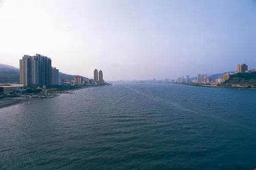
Seen from the Guandu Bridge, the Danshui River appears majestic and powerful. This beautiful waterway, rich in human heritage and natural resources, has many buried treasures that are worth a little extra digging to find.
Let's get reacquainted
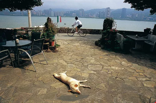
The Bali Left Bank, with its flourishing greenery and mountain-and-ocean scenery, has become one of the top choices for urbanites to chill out, and every holiday and weekend there is an inexhaustible stream of cyclists. On the right bank, the town of Danshui has interesting small streets, coffee shops, and the relaxing Fisherman's Wharf, where visitors go to watch the sunset or commune with the sounds of the ocean. Artists come here to find inspiration from the natural setting, especially the interplay of light and cloud-shadows. Meanwhile, environmental groups and local residents opposed to the construction of the Danbei Expressway scurry about, often out of sight but never out of touch, in their activities.
Amidst all this interaction between people and river, a group of "greens" have launched a program to create a "Danshui River Green Map," in hopes of getting people to think about new possibilities.
The idea for the map, which will offer in-depth understanding of the Danshui system and serve as a guide for people to undertake their own journeys, was hatched by the education bureaus of the Taipei County and City governments. It brought together the Society for Wilderness, the Guandu Nature Park, and other NGOs, and provided a system for local residents and schoolteachers along the riverbanks to contribute. From project design to completion took a year, and more than 50 people were involved in the planning, fieldwork, and drawing. They hope that this map will help city and county residents to better understand the rich variety of ecologies, and the many manmade sites of interest, in the river basin.
The Green Life Map focuses on the "mainstream" part of the Danshui, from the confluence of the Dahan and Xindian tributaries near the Huajiang Wild Duck Nature Park northward to the mouth of the river. It includes 104 points of importance, divided into 12 categories including green economy, plant life, animal life, cultural sites, resource reuse, etc. The map and index use the green life icons that have become standard around the world.
Using the map, people will find that in addition to the well-known downstream sections of the river at Bali and Danshui Townships, there is a lot to be discovered. For example, Shezi Island boasts a wholesale flower and plant market as well as an important bird habitat. Also, even industrial areas like Wugu and Luzhou enfold a "green education center" or "ecological zone" here and there, where plant and animal life thrives; there is a second-hand market under the Chongxin Bridge; the banks along the Dadaocheng and Wanhua areas of Taipei City are dotted with heritage sites; and much more!
Seen from the Guandu Bridge, the Danshui River appears majestic and powerful. This beautiful waterway, rich in human heritage and natural resources, has many buried treasures that are worth a little extra digging to find.
Ecological corridor
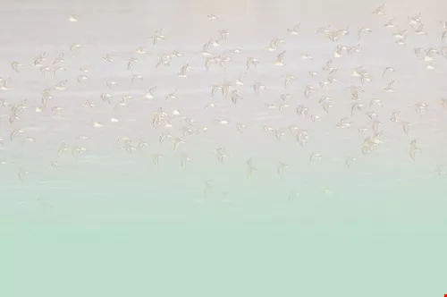
"In fact the ultimate aim of making this map is to link the five important wetlands areas along the Danshui River-which, from north to south are Waziwei, the Zhuwei mangrove forest, the Guandu wetlands, the Wugu wetlands, and the Huajiang Wild Duck Nature Park-into a single international-grade wetlands area," says Lai Jung-hsiao, deputy director of the Society of Wilderness and director of outreach for the Taipei County Sustainable Development Education Center. One of the main behind-the-scenes promoters of the map project, he hopes that the combined efforts of the Taipei City and County governments and NGOs will make the "Danshui Ecological Corridor" into Taiwan's third international-grade wetland, following in the footsteps of Qigu and Sicao in Tainan County. Not only will this provide an added level of protection for the tens of thousands of migratory birds who winter here, it can preempt inappropriate development plans all along the more than 30 kilometers of river that run alongside urban areas.
Lai explains that of these five wetland areas, "three-and-a-half" have been listed as protected zones (Wugu and that part of Huajiang lying within Taipei County have not been so designated). However, in the absence of a corresponding level of protection for the areas between the wetlands, severe harm can still occur to the ecology of the whole river and its banks.
One of the projects that has been the subject of continuous controversy is the Danbei Expressway, which is intended to run from Dadu Road past the Guandu Bridge, and connect to the Lee Teng-hui Highway. Another is the Danshui Bridge, which people have been arguing about for 20 years, to be built across the mouth of the river. But besides these major infrastructure works, there are countless similar local projects.
For example, the Taipei County Bureau of Agriculture plans to build a slipway in the dunes just outside the Waziwei conservation area for fishing boats to offload their catches. Because the site is outside the protected zone, no environmental impact study is mandated. Lai Jung-hsiao estimates that the constructing the slipway will block the flow of sand out of the river, worsening the problems of siltation and land formation. Moreover, he believes, the structure, budgeted at only NT$20 million, is unlikely to withstand the wind and waves at the river mouth and will lie in ruins after just two or three years. Equally regrettably, many sports fields and parking lots are being constructed in the riverside parks that run along the Keelung and Danshui rivers, and many new roads have been built very close to the Huajiang Park. Is all this construction really necessary? Do the projects conform to environmental principles? Someone should be keeping a close eye on these things.
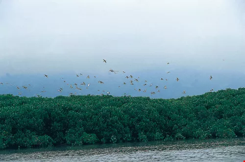
The Guandu Nature Park, located at the confluence of the Danshui and Keelung rivers, is breeding ground to a rich wetlands ecology, and flocks of migratory birds come here from Siberia every winter. (facing page:) There are many ways to explore the Danshui wetlands. Besides foot or bicycle, you can take a rowboat onto the water and feel the pulse of the river up-close.
Follow the birds
"A lot of people ask me, 'In promoting the ecological corridor, what are you trying to do here?' In fact my thinking is exactly the opposite-I just tell them that I don't want anything done here!" says Lai.
"Birds like the whiskered tern, which are normally active at the river mouth and in inshore waters, will head inland for safety when there are big storms. Of course they don't know which places are protected and which aren't. So if they find only concrete parking lots where they can't find food, or roads packed with cars belching out choking fumes, where can they find a safe haven?" A big problem, Lai points out, is that management of the wetlands is divided between six different central and local agencies, making it difficult to know who should do what, which is a big obstacle to organizing the river basin for purposes of conservation, restoration, and education.
For most urbanites, the only reasons to go to the river are recreational; so long as the river no longer stinks as it once did, they are content. As for battles over development vs. conservation, they just leave those to the conservationists! But Lai reminds us that we need everyone's genuine concern, something that can only come to pass when people have a deep understanding and direct experience of their environment. Only then will they willingly change the way they live.
So next time you get your friends together for a bike trip, why not follow the path of the migratory birds toward the midstream parts of the Danshui River? There you can choose a wetland area and, following the map or the volunteer guides stationed along the way, you can stop and have a closer look here and there. You may be inspired by the sight of crabs tirelessly building and rebuilding their homes in defiance of the relentless tides. Or perhaps staking out a spot in a mangrove forest and quietly observing egrets, so justifiably honored in Chinese poetry, is more your style. In any case, you will surely feel the life force of the river in a way you never have before.
.jpg?w=1080&mode=crop&format=webp&quality=80)

Seen from the Guandu Bridge, the Danshui River appears majestic and powerful. This beautiful waterway, rich in human heritage and natural resources, has many buried treasures that are worth a little extra digging to find.
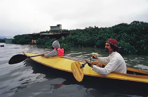
The Guandu Nature Park, located at the confluence of the Danshui and Keelung rivers, is breeding ground to a rich wetlands ecology, and flocks of migratory birds come here from Siberia every winter. (facing page:) There are many ways to explore the Danshui wetlands. Besides foot or bicycle, you can take a rowboat onto the water and feel the pulse of the river up-close.
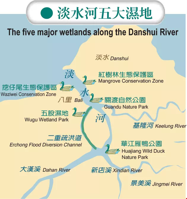
The five major wetlands along the Danshui River

The Waziwei Mangrove Reserve, located at the mouth of the Danshui River, is a showplace of estuarine ecology and single-species reedbeds, and its intertidal belt is home to creatures like fiddler crabs and mudskippers. Children love it here.

Winding through Taipei, Taoyuan, and Hsinchu, the Danshui is Taiwan's third largest river. In days gone by, when the river was still navigable by seagoing ships, many riverside settlements were turned into boomtowns by flourishing riverine commerce.


@List.jpg?w=522&h=410&mode=crop&format=webp&quality=80)


