In the Land of the Atayal-Nan'ao Historic Trail
Yeh Pin-yu / photos courtesy of Huang Xinfu, Forestry Bureau / tr. by David Smith
November 2011

Old trails are historic relics bequeathed by earlier inhabitants of the land we call home. Signs of the past, left behind by many different ethnic groups, can be found along such trails. With the passage of time, a path may be reclaimed by vegetation and associated buildings may fall into ruin, but once restored it serves much the same function as a time capsule-anyone who walks it can read its history. Moving slowly along, historic tales call out, and the power of nature manifests itself. Winding between peaks, and snaking through dense growth, a trail is amazingly bewitching and inviting.
Nan'ao Historic Trail is a secluded old pathway, recently reopened by the Forestry Bureau, that deserves a slow-paced visit.
Nan'ao Historic Trail is the 20th nature trail in Yilan County. Also known as Biyahao Historic Trail, it was just restored and opened to visitors this past April by the Forestry Bureau's Luodong Forest District Office.
Biyahao Historic Trail starts in the village of Siji, Datong Township, Yilan County. From there it meanders 27.5 kilometers eastward to Nan'ao Township. From the trailhead, it runs upstream along the South Nan'ao River. Both the Atayal people and the Japanese colonial authorities have left behind many a sign of how they made use of the trail in times past. The Forestry Bureau has thus far restored and opened three kilometers of the trail, which takes three hours to hike to the end and back.
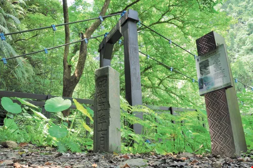
At 750 meters into the Nan'ao Historic Trail, hikers come across Suspension Bridge No. 1, which spans a tributary of the South Nan'ao River. Right next to it are the pillars for an earlier suspension bridge, bearing an inscription stating that it was completed in July of "the 5th year of the Showa Emperor" (1930).
Biyahao, otherwise called Bihou, was named Gulu in the old days. The main route of the old trail was worn into the hills by the Skadang branch of the Atayal tribe as they made their way from the upper reaches of the Dajia River, through the Siyuan Pass, and northeastward to the area around the Nan'ao River and the Dazhuoshui River (also known as the Heping River). During the Japanese colonial period, the Japanese used the trail in their administration of indigenous affairs, and established outposts at intervals along the trail. After Taiwan's return to Chinese rule in 1945, the trail gradually fell into disuse as local indigenous people moved out of the area. The Nan'ao trailhead is located at the southernmost tip of Yilan County. The Suhua Highway and the North Link rail line both pass through the area, which is still home today to a high concentration of Atayal people.
The portion of Nan'ao Historic Trail now open is the beginning part of the Biyahao Historic Trail. It starts at the Xuantan Outpost and follows the South Nan'ao River upstream through verdant forests and a diverse range of ecosystems. Along the trail are the pillars of a long-gone suspension bridge, the bed of an old police access road, and abandoned fields once farmed by the Atayal. In just a short stretch, the trail offers quite a bit of natural and historic interest.
To get to the Nan'ao Historic Trail, it is necessary to take the Suhua Highway to Jinyang Village. After that, follow the signs to the trailhead. Not too many cars venture down the road because it is so narrow, so the area is quite secluded. Traveling down the road, it feels as if you're gliding through a world of green-green mountains, trees, and plants-with a profusion of flowers to complete the scene. The breeze carries with it a scent of sunshine. Left far behind is the din of motor vehicles and human chatter.
As our party assembles at the trailhead, I can't help but chuckle at the distance marker informing us that we've hiked zero kilometers-"0K"-as if to assure that all will be "OK" for us.
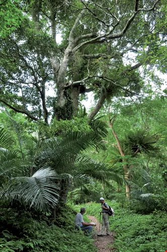
The old-growth forest along the Nan'ao Historic Trail stands guard over mountains and travelers alike. Two hikers stop to take a break beside the trail, get in touch with nature, and bask in the sensations of how our forebears once lived.
Before embarking on an old trail, it's a good idea to know its history.
The Nan'ao Historic Trail was a trafficway 200-plus years ago for the Atayal people, who hunted and farmed the land along the trail. Indigenous people also had their own fishing grounds staked out along the river, and used the trail to get to the Nan'ao Plain to collect salt.
The routes chosen by the indigenous people of an earlier time would be inconceivable to us today; they would simply take the shortest distance between two points-a straight line! That made for a lot of vertical ascents and descents.
Just as depicted in the movie Seediq Bale, indigenous people have a knack for bounding from boulder to boulder and tree to tree when hunting wild game or engaging in warfare. With their skill in finding shortcuts, they could easily overtake a less mountain-savvy army.
The Nan'ao Historic Trail of today is, of course, nowhere near as challenging as it once was. During the Japanese colonial period, the Japanese converted some of the Atayal trails into police access roads.
The biggest difference between the police access roads and the old trails is the relatively level grade of the police roads. The police roads of an earlier day led to the village of Siji in Datong Township, as well as Luodong and Nan'ao, thus forming a relatively large-scale "Greater Nan'ao transportation system." The Japanese used their extensive network of police roads to force the indigenous peoples out of their original villages and into the Nan'ao Plain. The story of their coerced migration is one of untold suffering and misery.
Green trail of the AtayalIn addition to built structures, the mountain flora also offer clues about life here in times past. Here the sugar palms, elephant's ear, pinstripe ginger, and China grass grow to sizes never seen in the hills near a big city. The same holds true for the Formosa begonia. The flourishing giant plants make for a very impressive sight.
All of these plants played important roles in the daily lives of Taiwan's indigenous peoples, so it would seem reasonable to assume that the Atayal people of an earlier time would have picked and made use of them as they made their way along the trail.
The Atayal typically harvested the sugar palm and fashioned its tough fibers into rope, or dried them out in the sun and wove them into straw hats, brooms, or roofing material. Pinstripe ginger fibers, once dried in the sun, could be worked into strings, or woven into mats, baskets, or infant cradles. And the gray-colored seeds of pinstripe ginger have long been a key ingredient in herbal stomach medicine and Jintan (a Japanese patent medicine).
Beating the heatSetting aside the bitter conflict that once took place here between the Japanese and indigenous inhabitants, today's Nan'ao Historic Trail is an excellent place to escape the summer heat, as the trail winds its entire length though a leafy forest along the South Nan'ao River.
Once you're well into the trail, it's a special treat to savor each step, and feel the springiness of the dirt beneath your feet. Where the trail ascends a relatively steep slope, stones spaced at ergonomically chosen intervals make the walking go smoothly.
The forest is thick and green. Few people pass this way, so it is a fully developed multi-layered habitat that greets the eye. The canopy layer is formed of tall trees such as Anguilla marmorata, Elaeocarpus, and Engelhardtia formosana. In the understory are found the Taiwan mountain longan, dwarf umbrella trees, and Chinese apea earring. On the forest floor, one will find pinstripe ginger, tuba root, palm grass, green foxtail, and chain fern.
Walking further, it begins to feel as if the entire world is a sun-dappled green, and eventually one enters a Zen-like state -a light sense of ease gradually pervades the inner being. We stroll slowly up to the hanging bridge and, while making our wobbly way across it, look down to the rushing creek below. The beauty of the boulders and water is intoxicating, inferior in no way to that of Taroko Gorge. Here, one forgets all mundane cares, and simply soaks in the unadorned charm of the place.
When hiking an old trail, there are no street signs or any of the other things we use in the city to navigate our way around. Instead, we must be alert with all five senses. And if you can, it is best to go barefoot to really appreciate the wordless speech of the ancient trail.
Location: Jinyang Village, Nan'ao Township, Yilan County
Length: 3 km
Level of difficulty: Gently sloping, easy to walk
Points of interest: South Nan'ao River; site of former suspension bridge
How to get there: From Su'ao, take Provincial Highway 9 to Jinyang Village in Nan'ao Township. Then take Yilan County Highway 57 west to a fork in the road where one option is to head for Shenmi Lake. Follow the down slope on the forest road traveling along the South Nan'ao River, and continue 11 kilometers to the trailhead.

@List.jpg?w=522&h=410&mode=crop&format=webp&quality=80)


