Storm Troopers Risk Life and Limb to Unlock Typhoon Secrets
Lin Hsin-ching / photos Jimmy Lin / tr. by Phil Newell
November 2007

The 1996 Hollywood flick Twister is set against the backdrop of scientists who "chase the wind": In order to unlock the secrets of tornadoes, researchers race across the open plains in jeeps, risking their lives to get scientific instruments into the heart of oncoming tornadoes.
Taiwan also has its "wind chasers." It's just that in this case twisters have been swapped for typhoons, and jeeps for a jet. Since September of 2003, the DOTSTAR research team, organized by the department and graduate institute of atmospheric sciences at National Taiwan University (NTU), has completed 28 flights to study 24 typhoons over and around Taiwan, successfully deploying 457 "Dropsonde" weather reconnaissance devices. The real-time information sent back by the Dropsonde devices not only helps the Central Weather Bureau to get a handle on the strength and size of typhoons, it also greatly increases the accuracy of predictions about the path a typhoon will follow.
At 4:30 in the afternoon of September 17, Typhoon Wipha (a moderate-strength storm) was rapidly approaching Taiwan, and the outer edge of the storm system was advancing across the ocean and land surface of northeastern Taiwan, with winds and rain progressively increasing. It was certainly not the kind of weather that one would call "suitable for flying," and a lot of citizens were canceling their scheduled air trips. And yet, over at Taichung's Chingchuankang Airport, there were several people and one small commercial jet plane-a mere four-seater-getting ready to take off. They were not thrill-seekers, but researchers, looking to study the structure and characteristics of Typhoon Wipha. They are the DOTSTAR team, renowned throughout the international meteorological community.

Bad weather flying
Amidst wind and rain, the small jet plane burst through dense cloud layers, and headed toward the peripheral circulation of Typhoon Wipha. Less than an hour into the flight, the sky was already nearly completely black, and the pilot could no longer tell his direction by sight, having to rely entirely on the instrument panel and radar to determine his position. Wu Chun-chieh, the leader of the team and a professor in the Department of Atmospheric Sciences at NTU, used a satellite phone to maintain constant contact with Daniel Wu, director of the Weather Forecast Center of the Central Weather Bureau (CWB), hoping to avoid the cloud layers and rainbands with their intense convective currents.
At 1730 hours, the team released the first GPS-equipped Dropsonde over the sea off the northeast coast of Taiwan. Then, moving around the peripheral circulation in a counterclockwise direction, they deployed the remaining 14 devices. These would measure data like wind velocity, wind direction, humidity, and barometric pressure, and immediately relay this data to the CWB and early-warning agencies in various countries.
Wu Chun-chieh says: "Most of the time we went up to take measurements in the past, the storms were still quite far from Taiwan, and the weather over Taiwan proper was still good for takeoff and landing. But this time the typhoon came on too quickly, and Chingchuankang Airport was already swept with wind and rain, so the plane really shook a lot during takeoff and landing. Fortunately, there was no harm done."
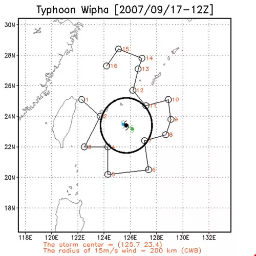
The map in the left photo shows the route followed by the DOTSTAR team during Typhoon Wipha in September of 2007; each dot marks the location of a Dropsonde release. (courtesy of Wu Chun-chieh) The right photo is a satellite image from the same time as the flight.
Origins of DOTSTAR
For this team, flying around the outskirts of a tropical cyclone (as typhoons are generically known) is just another day at the office. The idea for monitoring typhoons originated back in 2001, when eight such storms swept over Taiwan. These included Typhoon Trami, which brought a devastating southwesterly airflow and heavy rains to Kaohsiung; Toraji, which brought heavy rains to Hualien and Nantou, causing severe landslides; and Nari, which hung over Taiwan for a record-breaking 49 hours, leading to massive flooding in Taipei City. During that year's typhoon season (late summer and early fall), tropical cyclones took 224 lives, left another 129 persons missing, and caused NT$13 billion in damage to the agricultural, fishing, and animal husbandry sectors.
After that disastrous lesson, in an effort to gain a better understanding of typhoon behavior, the following year the National Science Council commissioned Wu Chun-chieh-who had previously participated in hurricane research and monitoring in the US-to map out Taiwan's own "wind chaser" program. The goal was to use aircraft monitoring to gain knowledge of a typhoon well before it approached Taiwan in order to reduce subsequent losses.
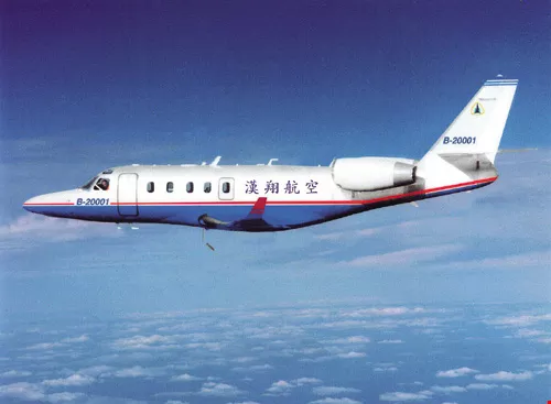
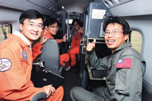
Since going into action in September of 2003, the DOTSTAR team of National Taiwan University's department and graduate institute of atmospheric sciences has completed 28 missions to take measurements on 24 separate typhoons that approached close to Taiwan, providing crucial data to weather bureaus in many countries. Third from left in the photo is program director Wu Chun-chieh. At right is the small Astra jet of the Aerospace Industrial Development Corporation.
Just drop me off here...
DOTSTAR director Wu Chun-chieh says that the essence of the program is to devise ways to overcome the current inadequacy of data about tropical cyclones. The mode of operation is that each time a typhoon is likely to affect the seas or territory of Taiwan, the researchers climb into their small jet before the storm arrives and fly into the airspace above the storm system. There they throw off between 15 and 20 Dropsonde devices to collect meteorological information about the typhoon. Dropsondes look like ordinary tubular containers, but at NT$35,000 each they are rather expensive. Inside they are equipped with wireless transmitters, as well as sensors for air pressure, moisture, and temperature. They also contain GPS receivers and antennae, which combine the functions of calculating wind velocity, wind direction, and position. When a Dropsonde is released through the bay in the fuselage of the aircraft, it begins to drop from 42,000 feet (about 14 kilometers) at a rate of ten meters per second. Every half second it sends out data to the researchers in the aircraft right up until it finally crashes into the sea. The team then encodes the data and transmits it to the CWB and early warning agencies in various countries.
The main weather prediction system used worldwide-numerical weather modeling-incorporates data from land, air, and sea monitoring around the globe. Along with other estimated values, these data are entered into a supercomputer which crunches the numbers and extrapolates future changes in the weather system. "By entering in first-hand measurements of typhoon data, the original numerical values used for typhoon structure, size, and path can be validated or corrected," explains Wu.
The Astra operates at about 42,000 feet, about 10,000 feet above normal civilian aircraft, in order to avoid the terrible weather in lower-level clouds. But they still routinely run into serious turbulence that causes unpredictable shuddering and shaking of the aircraft.
Number two, and proud of it
Taiwan is not the first country to use aircraft to chase the wind. As early as WWII, in the Pacific campaign against Japan, the US sent aircraft into typhoons to collect data in order to estimate the possible impact of storms on naval operations. On July 27, 1943, Colonel Joe Duckworth, flying an AT-6 trainer from Bryan Field, Texas, became the first person to fly through the eye of a tropical cyclone. Thus began the use of manned aircraft by the US to monitor such storm systems.
Typhoons and hurricanes are localized names for tropical cyclones, and there is no substantive difference between the two. Normally tropical cyclones that are born in the Northwest Pacific or South China Sea are called typhoons. Those in the western part of the Atlantic Ocean, the Caribbean, the Gulf of Mexico, and the northeastern Pacific Ocean are called hurricanes. Because the southeastern United States is exposed to frequent hurricanes, monitoring flights have become routine. As soon as a hurricane appears in that region, the US Air Force and the Hurricane Research Division of the National Oceanic and Atmospheric Administration (NOAA) immediately dispatch planes-each organization having its own unique missions and objectives-to monitor and measure the storm.
The US uses two basic ways to monitor hurricanes. One uses a C-130 transport, a four-propeller aircraft, which is fitted out and deployed by the USAF, and a WP-3D (a refitted version of the P-3 anti-submarine warfare plane), which is under the command of the Hurricane Research Division of the NOAA. They fly through the center of the hurricane at low altitude, following a route shaped like a Greek letter "a." Because a tropical cyclone is in the shape of column of air, if you think of one like a cake, then the C-130 and P-3 are like knives slicing through laterally to collect data.
The other method employed by the US uses a G400 small jet, flying at high altitude, and deploying Dropsondes around the outskirts of a typhoon. This is akin to sticking a skewer into the cake, around the outside edge, from the top down to the bottom. This provides complete data on the wind and temperature fields, including the size and structure of the storm, to estimate its radius of maximum winds and future direction. This is the approach adopted for DOTSTAR.
For a time the US also sent out aircraft to monitor typhoons in the Pacific, but this program was terminated in 1987 for budgetary reasons. It would be 16 years before DOTSTAR finally rode to the rescue to carry on this work. "Now Taiwan is only the second country in the world to successfully monitor tropical cyclones with manned aircraft," says Wu Chun-chieh with a confident smile.
The release chute for Dropsondes is located in the center of the fuselage; the devices are deployed when the aircraft reaches specified points along the outer edges of the typhoon.
Pathfinding
Besides assessing typhoon structure, another accomplishment of the DOTSTAR program is to improve predictions of the paths of tropical cyclones, which has long been a headache for forecasters around the world.
The pathways of typhoons that form in the western Pacific are affected by a number of factors, especially "steering" winds and the dynamics of the typhoon itself. The steering winds, in turn, can come from Pacific high pressure areas, southwesterly monsoon winds, or even northern weather fronts. Of these, the steering effect is most pronounced in the case of Pacific high pressure. For example, during summer when high pressure over the Pacific Ocean is strongest, the position of typhoons is restricted to relatively low latitudes, and they are more likely to follow westerly paths that take them into Taiwan or the Philippines. But if the Pacific high pressure retreats eastward and decreases in strength, typhoons are more likely to follow the high pressure ridge and head northwest toward Japan.
Daniel Wu explains that the factors that affect the track of a typhoon are very complex. Generally speaking, the stronger a typhoon is, the easier it is to predict. Because of the earth's rotation, tropical cyclones in the northern hemisphere spin in a counterclockwise direction. When the storm reaches a certain strength, forecasters can easily work out the interaction between the typhoon's own dynamics and the effect of the steering winds. On the other hand, if the typhoon is weak, sometimes you can't even locate the eye, so naturally it is more difficult to judge its movement.
To better measure the complex variables that can affect a typhoon's path, DOTSTAR's Dropsondes penetrate deep into the "sensitive regions" around the edges of a storm to do "strategic reconnaissance." One example of a sensitive region, says Wu Chun-chieh, is the boundary of a Pacific high pressure area, which comes closest to typhoons during the summer. The extent and strength of such sensitive areas, and the wind direction within them, will affect the wind field of a tropical cyclone, and can determine its future direction.
The experience that made the greatest impression on Wu was during Typhoon Conson, which hit in June of 2004. "When Typhoon Conson was just north of Luzon, the weather forecasters in various countries were all saying that it would sweep along the southwestern edge of Taiwan. But our field data indicated that the southwest winds in the seas where the typhoon was located were increasing in strength, which would push the storm toward Japan. The various weather bureaus may have amended their predicted paths in part because of our inputs."
Of course Dropsonde data is not perfect, and sometimes is of only marginal value. Wu relates: "On average, it can improve the numerical models used by the various national meteorological agencies to predict the path of a tropical cyclone over a 24 to 72-hour period by about 20%. For instance, if the predicted path is off by 100 kilometers, then Dropsonde data can help reduce that to 80 kilometers."
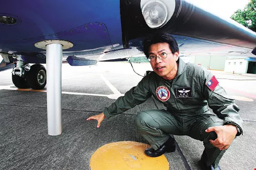
The fuselage of the Astra has a record of all the typhoons investigated by the DOTSTAR team. At right is Wu Ching-wen, head of the AIDC's Aeronautical Engineering Department, explaining how Dropsonde weather surveillance devices are released.
Risky business
DOTSTAR is a manifestation of the human ambition to grasp the unknown variables of nature. But since an ordinary person would be uncomfortable, or even nauseous, in turbulence, doesn't it seem a little bit crazy to fly right into a typhoon-the worst weather there is?
Lin Po-hsiung, an assistant professor of atmospheric sciences at NTU, who is co-director of the DOTSTAR program, and who has been the flight team leader on many occasions, explains that whereas most commercial planes fly at 25-30,000 feet (about eight to ten kilometers), the research plane operates at 42,000 feet (about 14 kilometers), in order to get around the turbulent weather in lower cloud layers. Nonetheless, when the aircraft is actually circling a tropical cyclone, it still hits convective cloud systems that cause it to lurch and vibrate unpredictably.
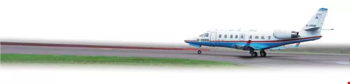
DOTSTAR currently uses a small Astra jet leased from the Aerospace Industrial Development Corporation (AIDC). This type of plane is a modified G-100 sold by the Gulfstream company of the US. However, it is much smaller than the G-400 used by the NOAA, which can seat ten persons and has a workstation computer for each crew member. Because of the Astra's limited fuel capacity, moreover, each flight has to be limited to no more than six hours.
Although Lin emphasizes that DOTSTAR uses precision technology, so that the monitoring process is ordinarily very safe, just in case he always makes sure his accident insurance is in order before each mission. "Our flight path usually takes us over the seas east of Taiwan. The scariest possibility is that we'll have engine problems, and there would be nowhere in the stormy seas to put down. That would really spell trouble."
Through the eye
Talking about the risks of wind chasing, Lin Po-hsiung and AIDC's chief pilot Tsao Chia-hsiang say that their most unforgettable experience was during Typhoon Melor, back in November of 2003.
"Melor was an autumn typhoon, with a very erratic path. It was only when we were just about to leave Taipei to head to the airport in Taichung that we found out that the typhoon had turned northward in the seas north of Luzon. Our original flight plan was therefore going to take us straight through the middle, and there was no time to change the plan if we wanted to take off," recalls Lin. "But since Melor was relatively weak, we decided to follow the original route, since we also considered that this was a good opportunity for us to try something we had never done before."
Tsao Chia-hsiang, who has over 30 years of experience as a pilot, says: "When we flew straight into the wall around the eye, where the wind and rain were strongest, the whole plane was getting tossed around violently. Up ahead all I could see were thick clouds and gray mist. Visibility was zero."
Lin Po-hsiung, who was team leader, describes his own feelings at that time: "I was thinking to myself that I would count to 30 and if there was no improvement I would have the pilot turn back. Luckily things stabilized after a moment, and suddenly there was no wind, no rain, and I realized that we were above the eye of the typhoon."
A lot of valuable data was collected on that flight. But for safety reasons they have gone back to circling the periphery of tropical storms, and will never again so casually take such risks.
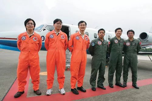
Since going into action in September of 2003, the DOTSTAR team of National Taiwan University's department and graduate institute of atmospheric sciences has completed 28 missions to take measurements on 24 separate typhoons that approached close to Taiwan, providing crucial data to weather bureaus in many countries. Third from left in the photo is program director Wu Chun-chieh. At right is the small Astra jet of the Aerospace Industrial Development Corporation.
Flight plan blues
Besides the risks of the flights, in fact DOTSTAR's challenges can even begin with the flight plans themselves.
Wu Chun-chieh points out that the movements of typhoons are quick and erratic, so that the flight plans for wind chasing have to be made in accordance with the position and direction of the storm; it is not possible to pre-schedule specific flight times or routes. Taiwan's airspace is small, and the planes can end up flying farther north or south as they chase the storm, so they could cross into Japanese or Philippine jurisdictions. But according to international civil aviation regulations, if you want to cross into the airspace of another country, you have to file a proposed flight plan at least ten days in advance. "The problem is, if ten days before you don't even know if there is going to be a typhoon at all, much less where, how can you file a flight plan?"
To address the flight plan problem, the research team first sought help from the Ministry of Foreign Affairs. But given Taiwan's awkward diplomatic position, the MOFA recommended keeping things non-governmental on the Taiwan side. Wu then directly contacted the typhoon research center of the Japan Meteorological Agency and with their help approached Japan's Civil Aviation Bureau. "The Japanese officials understand very clearly that the data from DOTSTAR is very useful for them as well, so they kindly helped to resolve the critical issues. Now we just apply for permission for flights each month in advance, then file a specific flight plan two days before taking off. The Philippines has decided to work with us along the same lines."
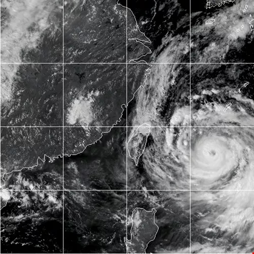
The map in the left photo shows the route followed by the DOTSTAR team during Typhoon Wipha in September of 2007; each dot marks the location of a Dropsonde release. (courtesy of Wu Chun-chieh) The right photo is a satellite image from the same time as the flight.
The chase is on
Having overcome all obstacles, since September of 2003 there have been 28 flights sent up to monitor and measure 24 typhoons close to Taiwan, with total logged air time of 147 hours and the successful release of 457 Dropsondes.
Success, as usual, breeds imitation. The Physics Department at National Cheng Kung University has installed special image recorders on DOTSTAR flights to investigate the phenomenon of upper atmospheric lightning. There is now also a "rain chaser" program (more formally known as the Southwest Monsoon Experiment), led by NTU Atmospheric Sciences professor Ben Jong-dao Jou which studies southwesterly airflows. This program got off the ground in 2006, and uses Dropsondes to measure the strength and moisture distribution of southwesterly airflows brought on by "plum rain" weather fronts, for reference in mitigating the impact of natural disasters.
This June, the Southwest Monsoon Experiment program conducted six further runs. Lin Po-hsiung, a rain chaser in addition to being a wind chaser, says that the weather is even worse than for DOTSTAR flights. "When a 'plum rain' front sweeps over, the western part of Taiwan has heavy rains and lightning, and the plane gets tossed around even more severely. Once the weather got so bad that all the airports closed, and the plane had to circle around for a long time looking for someplace to land, until finally the Hsinchu airport luckily opened up."
Ben Jou says that in the future the rain chasers will consider using airfields in eastern Taiwan, which are less affected by "plum rain" weather fronts, in order to avoid the worst weather conditions and make takeoffs and landings safer. "We plan to negotiate with AIDC about this."
(facing page) The interior of the Astra is small and narrow. After stuffing in the pilot, co-pilot, and weather monitoring equipment, it seats only four persons.
The sincerest form of flattery
The DOTSTAR program has earned considerable international respect. They have been invited, starting next year, to join in the THORPEX/PARC program, which will be a cooperative program among the central weather bureaus of countries in East Asia, Europe, and the Americas to monitor and take measurements on the climate. Also, the typhoon research center of the Japan Meteorological Agency has decided to adopt the Taiwanese model, and next year will join the ranks of countries monitoring tropical cyclones using manned aircraft.
"Japan will monitor storms that head toward Japan, while Taiwan will continue to monitor those that come toward Taiwan. If a typhoon happens to pass through the seas between Japan and Taiwan, then both sides will mobilize. It could be that the Japanese will take the northern side and the Taiwanese will cover the southern side, with the result being much more complete data on the storm," says Wu Chun-chieh.
Although the "wind chasers" have accomplished much, Wu Chun-chieh believes that it would be best if the government were to establish a specialized weather research agency to take over the program. "For example, in the US, for each and every hurricane the air force and the Hurricane Research Center are out every day monitoring the storm. But because in Taiwan funding is limited, in general we can only take measurements once for each typhoon, so there is by comparison a lot less data than one would like. The only way to get enduring results would be if we could follow the US example in the future and have routine monitoring flights."
With its scientists flying right into the worst weather that nature can dish out, Taiwan, based on its geographic position, is able to serve as the guard at the gateway helping to ensure the safety of the countries of the northwest Pacific. If the valuable experience of the DOTSTAR program can be extended, it will not only serve as a model for other countries, it can also greatly raise the visibility of Taiwan in the international meteorological community.
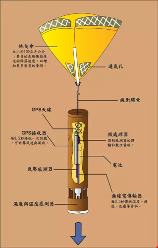
A cross-cut view of a Dropsonde. Inside are instruments to measure temperature, humidity, and air pressure.
At least three or four typhoons hit Taiwan each year, causing over NT$10 billion in damage. The DOTSTAR program has had considerable success in collecting concrete data to improve understanding of tropical cyclones, becoming a model for similar operations in other countries.


