Rising on the Tide: Taijiang National Park
Coral Lee / photos Hsueh Chi-kuang / tr. by Jonathan Barnard
May 2011

What place in Taiwan best demonstrates the living history of the Han Chinese pioneers who wrested a living from the wilderness of Formosa, four centuries of Taiwan's changing geography, and the rise, fall and transformation of the island's agriculture and fishing sectors? The top choice is a no-brainer: Tai-jiang National Park.
With its historical significance, diverse flora and fauna, ancient waterways, and stunning lagoons and wetlands, Tai-jiang became Taiwan's eighth national park at the end of 2009. It's much more easily accessible than the several national parks located high in the mountains or the offshore parks of Kin-men and Dong-sha. What's more, Tai-jiang takes visitors on a journey through time, prompting them to -awaken their slumbering senses so as to re-experience Formosa, the beautiful isle.
Gaze upon a map of the coastal areas of Tai-nan, and you'll notice they're full of fishponds, saltpans, land reclaimed from the sea, lagoons, sandbars and the like. This rural water kingdom scenery offers glimpses of how coastal land has been taken from the sea over the course of 300 years.
In reality, it's not just these rural coastal areas that have been reclaimed. Even the bustling west side of downtown Tai-nan used to be under the water of the Tai-jiang Inland Sea. It was the site of a naval battle where Ming loyalist forces led by Zheng Cheng-gong (Koxinga) defeated the Dutch. And that old inland sea also included much of what is now Tai-jiang National Park.
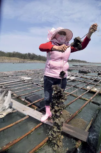
Raising oysters requires using different methods at different water depths. The "trellis rafts" in the photo are used at a depth of three meters in the Qigu Lagoon. Strands of oysters grow on strings hanging down from the poles, and the ends of the rafts are anchored in place. In shallower water the bamboo poles are directly inserted in the riverbed.
A hand-drafted map from the Dutch era shows Taiwan proper on the east side of the Tai-jiang Inland Sea, and a string of sandbars and islands (including Lu'er-men, Bei-shan-wei, and Da-yuan) on its west side. The topography made the Dutch settlements here hard to attack. The Dutch East India Company built the sturdy Fort Zee-lan-dia (Fort Anping) on Bei-shan-wei, next to a narrow passage connecting the inland sea to the Taiwan Strait. On the east side of the inland sea, they built Fort Pro-vin-tia (now site of the Chi-kan Tower), where they located their administrative offices.
In 1661 forces under Ming loyalist Zheng Cheng-gong on the coast of Fujian Province were exhausted and short of supplies, so they hatched a plan to move east to Taiwan. Zheng's 35,000 men sailed across the strait on 400 large junks. From Liao-luo Bay in Kin-men, the mighty fleet stopped first in the Penghu islands. Then, amid a heavy fog, they stealthily approached Lu'er-men. Yet because the channel to the Tai-jiang Inland Sea was too shallow, they could not enter the -inland sea. Consequently, Zheng switched to a smaller boat and landed on Bei-shan-wei Island. There he took a look at the lay of the land and burned incense as an offering to Mazu, the Taoist goddess of the sea. Apparently, the offering worked, because not long afterwards, the tides at Lu'er-men rose abruptly, bearing up the large boats and providing entry.
Zheng divided his fleet into three groups. One stayed outside in the Taiwan Strait. The other two spread between Fort Zee-lan-dia and Fort Provintia in the inland sea. Zheng first broke the Dutch defensive lines on the east side of the sea, north of Fort Pro-vin-tia. Five days later he attacked the weakly defended Fort Pro-vin-tia, causing all the Dutch to flee to Fort Zee-lan-dia, where they made their last stand.
When you arrive at the mouth of the Lu'er-men River today-where Zheng's forces and the Dutch fiercely battled-you can climb to the top of the dike to see the blue waters of the Taiwan Strait and read a stone tablet that commemorates Zheng's glorious victory over a Western power. Here, amid the billowing waves, the history of Han Chinese rule in Taiwan began.
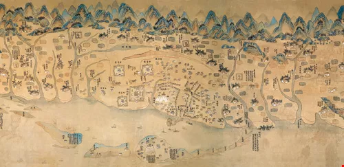
A Kangxi-era map of Taiwan represents the island horizontally, and shows how the Chikan Tower stood on the eastern shore of the Taijiang Inland Sea, while Fort Anping stood alone on the western shore.
Further back, before Dutch rule, Taiwan was an untamed island in the sea. For thousands of years, its only residents were Aborigines, who lived primitive lives hunting, fishing and planting. During the Age of Discovery in the 16th century, European sea powers, including Spain, Portugal and the Netherlands, sent ships thousands of miles to Southeast Asia and the South China and East China seas in search of silk, china and other goods. Various Western nations coveted Taiwan, since its location made it an excellent central relay station in the Western Pacific.
In China's eyes back then, Taiwan was a place rife with disease and populated by uncivilized tribes. The first Han Chinese to live on the island were members of bands of pirates based along the west coast. From the middle of the Ming Dynasty, droughts caused famine in Fu-jian Province, pushing refugees to make the dangerous journey across the Taiwan Strait. Han Chinese settlements gradually began to form in Formosa.
After Zheng Chenggong defeated the Dutch, he established his capital at Fort Pro-vin-tia, which he renamed Cheng-tianfu. It was the first governing center established by Han Chinese in Taiwan. For the tens of thousands of officers and men under his command, Zheng instituted a policy whereby soldiers would work as farmers during times of peace. He divided up the land, giving a portion to each battalion. These soldiers settled down and raised families in such villages as Hou-ying, Lin-feng-ying and Zuo-ying (ying means camp in Chinese).
Zheng died young, and his son Zheng Jing took over, appointing Chen Yonghua as his adviser. The two took active steps to develop Taiwan, building schools and a temple dedicated to Confucius, and establishing a Han Chinese society based on Confucian thought. They also constructed water infrastructure and taught the people how to obtain salt from seawater.
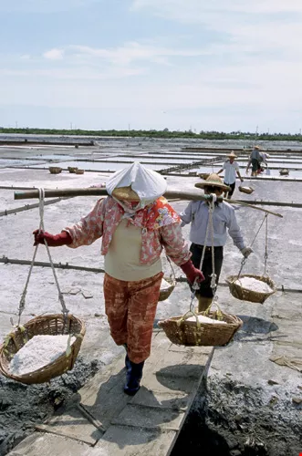
At Sicao's Salt Field Ecology and Eco-Culture Village, one can see traditional methods used to produce sea salt. Salt makers put on demonstrations here. In good weather salt can be gathered once every two days. The tiled saltpans are visible in the background.
Apart from encompassing battlefields and other sites that pay homage to Zheng Cheng-gong's contributions to Taiwan, Tai-jiang National Park also includes a maritime portion that stretches from the mouth of the Yan-shui River to -Penghu's -Dongji Island. A segment of the trading route between Taiwan and Southern Fujian, this stretch of water was also part of the perilous "black water channel" that the Han Chinese pioneers in Taiwan had to brave to settle on the island.
"I urge you not to go to Taiwan, for Taiwan is truly the gates of Hell. A thousand go but not one returns. Who knows if they're dead or alive?" "Lament of the Taiwan Crossing" bears witness to the misery and hardships borne by those pioneers who left China for Taiwan. Yet despite the danger, people from Fu-jian and Guang-dong would continue to come.
Once Zheng's Ming loyalist forces were established in Taiwan, they became a thorn in the side of the Qing court, which issued an order outlawing emigration to Taiwan. The court even decreed that no one could live within 18 kilometers of the coast of southeast China. The idea was to isolate Taiwan, severing lines of support for Zheng's forces. But by forcing people from their homes, it engendered resentment, and the numbers of people secretly leaving for Taiwan only grew.
Zheng Jing's son Zheng Ke-shuang surrendered to the Qing 22 years after his grandfather led his forces across the strait. Even then the Qing left in place strong prohibitions against cross-strait contact. But in the more than 100 years from the rule of -Kangxi (1661-1722) to Qian-long (1735-1796), the Qing proved powerless to stem the flow of immigrants from Fu-jian and Guang-dong to Taiwan. Because there was insufficient land for planting along the coasts of both of those mainland provinces, population growth led to chronic famine. Consequently, those provinces' poor residents proved repeatedly willing to brave the dangers of the passage-whatever their fate. The dangers of the journey were memorialized in the phrase, "Ten went, six died, three survived, and one turned back."
There were 100,000 Han Chinese living in Taiwan in the Dutch era. By the last years of Qian-long's rule, that population had grown to 900,000.
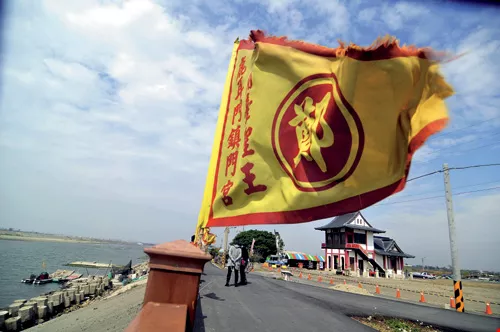
The mouth of Lu'ermen River is where Zheng Chenggong entered the old Taijiang Inland Sea via a perilous channel more than 300 years ago before prevailing in a bitterly fought nine-month war against the Dutch. The Zhenmen Temple in the background features "Dutch" door gods with European features.
The Han pioneers in Tai-jiang left behind many traces of how they wrested a living from their new land, including techniques of fishing, farming and sea-salt production. Even today there are still people making a living from those traditional methods, as well as cultural activities connected to them.
For instance, in rivers, streams, irrigation channels and tidal areas throughout the Taijiang area, one often sees bamboo poles inserted in parallel lines or in the shape of a V.
With the V-shaped pole arrays, nets can be put in place to create a semi-enclosed space where fish enter with a rising tide and get trapped inside as the tide recedes.
The oyster industry is another important component of Tai-jiang's economy, and oysters are cultivated throughout the river channels and lagoons.
Oyster cultivation was first introduced here more than 300 years ago by immigrants from Fu-jian. This ancient form of mariculture is very environmentally friendly. Bamboo poles are inserted in tidal areas. Tiny oyster larvae attach themselves to the poles, and feed on plankton and algae suspended in the tidal waters, gradually growing into large clumps of meaty oysters. No feed is required at all, and the oysters produced are rich in glycogen and protein. With their high nutritional content, oysters have long been an important form of sustenance in coastal areas.
Huang Zhiyu, who has raised oysters for more than 20 years in the -Qigu Lagoon, is very proud of the quality of the local oysters. Oysters can easily accumulate heavy metals, and many of the oysters raised in Taiwan are cultivated in areas that suffer from industrial pollution. But with living water that is replenished with every rising tide in the lagoon, the oysters there can be eaten raw. Locals may just pry one open and ask you to try it.
Encompassing 1600 hectares, the -Qigu Lagoon could be described as a smaller version of the Tai-jiang Inland Sea (occupying about one-tenth of its original area). It is enclosed by three sandbanks. Apart from protecting the coast against surges during typhoons, they also serve the purpose of modulating the mix of fresh and salt water and filtering effluent from fishponds. Because nutritive salt is abundant here, it's an excellent place for young fish to seek shelter. The lagoon holds at least 200 different species of fish, shrimp and other shellfish. It's a natural site for mariculture. No wonder then that a plan to reclaim land from the lagoon to build petrochemical and steel plants under the controversial Bin-nan Industrial Development Project some 20 years ago prompted sharp objections from local fishermen and oyster cultivators.
When you visit, take a boat ride through the vast lagoon. Apart from hearing the skipper explain how Mother Nature provides for local fishermen, you can enjoy the sight of fishing cormorants perching on misty pillars marking the navigation channel. The birds seem to be peering off into the distance as if to remind people: Take the long view and continue to protect this treasure passed down from your forefathers.
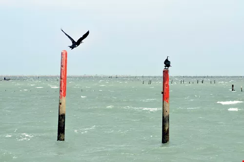
Cormorants in Qigu Lagoon enliven the vast expanses of water. In the mists, against a background of oyster racks and stationary fishing nets, the birds acquire a poetic quality.
The earliest pioneers installed nets to capture fish and inserted bamboo poles to raise oysters. By the Zheng Cheng-gong era, people had already developed the practice of flooding low-lying areas with seawater, and then letting the water evaporate to yield sea salt.
Modern saltworks began to appear during the Japanese era. The An-shun Saltworks, the first of those facilities, is located in Sicao's Salt Field Eco-Culture Village. The bottoms of its saltpans are lined with red tile shards, pieced together like a giant work of installation art. Through the thin layer of seawater that covered the saltpan when this reporter visited, salt crystals could clearly be seen in the spaces between the tile shards. (Saltpans can also be lined with clay rather than tile.)
Workers at the Salt Field Eco-Culture Village explain that the procedure for producing sea salt back then was to build dikes around large evaporation ponds. After a first phase of evaporation, the resulting highly saline brine would be emptied into a smaller pond, before another round of evaporation and emptying into a "crystal pond," from which the salt would be extracted.
The saltworks, established in 1919, originally covered an area of more than 400 hectares and produced massive quantities of salt. A canal and wharf were built so the salt could be transported to a factory in Anping for processing before being shipped to various locales around Taiwan and abroad.
After Taiwan's return to Chinese rule, the saltworks changed from producing salt for human consumption to producing salt for industry. By the 1980s the salt produced here by the labor-intensive process was no longer competitive with imported salt produced by highly mechanized processes. What's more, most of those toiling under the sun in the saltpans were getting on in years. In 1991 the Ministry of Economic Affairs took half of the 400-plus hectares and gave them to the Tai-nan Technology Industrial Park, and the other half was used by the Council of Agriculture to establish the Si-cao Wildlife Refuge. After the An-shun Saltworks completely shut down in 1998, some 100-plus workers who lived in this area gradually moved out, leaving the village here largely deserted.
Yet the deserted salt fields and neighboring fishponds attracted large numbers of water birds, including black-faced spoonbills, black-winged stilts, and Kentish plovers, which came to forage and build nests. These provided a means of rebirth.
In 2001 architecture scholar Lu Jianming was hired by the Council of Cultural Affairs to conduct an industrial-cultural survey and assessment at the Nanliao Salt Village. Finding himself deeply attracted by the abundant wildlife as well as the relics of salt manufacturing, he came up with the idea of resurrecting the culture of the salt village. He moved to the village on his own initiative and applied for grants from the CCA and other government agencies. He recruited more than a dozen salt makers and several other salt workers, and organized them into a team to produce salt through seawater evaporation, thus reviving traditional methods of manufacturing salt. He also trained guides, helping to put the village on track for eco-tourism.
Working on the project for many years, the villagers have developed a sense of mission about preserving saltpan culture. Children of former salt workers have enthusiastically participated in recent years, helping to form a salt makers association. Lu has gradually stepped back, and now the eco-cultural village is administered by the villagers themselves. Those who would like to see how salt is harvested need only to call in advance.
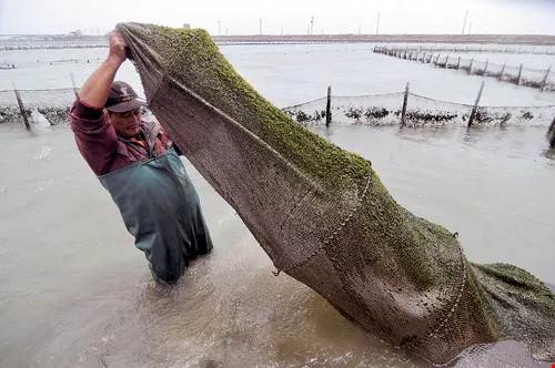
V-shaped tidal fish traps are a common sight in shallow water throughout the Taijiang area. The photo shows a fisherman pulling up the net that captures the fish at the point of the V.
The Yan-shui, Lu'er-men and Zeng-wen rivers flow into the sea in Tai-jiang National park, and the park is full of estuaries, tidal zones, mangrove forests and other wetland ecologies. The -Qigu Lagoon and the Si-cao Inland Sea in the park are remnants of the Tai-jiang Inland Sea. When you add the farming, fishing, and salt industries, the diversity of wetlands here is greater than anywhere else in Taiwan. In particular, the Si-cao wetlands and the wetlands at the mouth of the Zeng-wen River are regarded as having international importance.
The abundant wetlands provide ample food and areas in which to hide. What's more, Taiwan is located along migration routes for water birds in East Asia. Every fall, many tens of thousands of migratory birds pass through here on their way south to warmer climes, before returning north in the spring. Others, including about 1000 black-faced spoonbills (or about half the global population of the endangered species), stop here to overwinter.
Tourists who come to Tai-jiang from October to March shouldn't miss the opportunity to visit the birdwatching pavilion in the Black-Faced Spoonbill Reserve, where one can enjoy views of these avian guests of Taiwan, which have flown some 2000 kilometers from their summer homes in North Korea or Northeast China.
When this reporter arrived, high-powered telescopes in the pavilion were trained on a vast beach more than a kilometer away where more than 200 black-faced spoonbills nestled together, leaning into the breeze off the ocean. The volunteer on duty said that the birds-apart from a few "standing guard"-were resting, and had gathered together to take warmth from each other. They leaned together to keep their feathers smooth, because ruffled feathers would affect their flight and might result in their demise if they were attacked by a peregrine falcon or other predator.
This reporter visited at the end of March, before the black-faced spoonbills flew north. Already wearing their yellow breeding feathers, they would soon take off on the 20-day journey to reach their breeding grounds. At the end of May the chicks will hatch, and by the middle of July they will become juveniles and spend the next two-plus months learning how to fly. At the beginning of October they must accompany their parents on the demanding journey southward.
Even when the spoonbills are gone, the reserve and the various neighboring wetlands are still full of avian footprints. All told, more than 200 bird species can be seen in Tai-jiang National Park. About 140 migratory bird species (including snipes, sandpipers, plovers, gulls, herons, geese and ducks) make up about 75% of the total. Resident birds comprise the other 25%. The bio-resources of Taijiang's intertidal zones represent another one of the park's big selling points. Take, for instance, the 49 species of crabs in the park. The sight of thousands of them scurrying hither and yon never fails to impress.
When you visit Tai-jiang, don't forget to find a place along the shore to watch the sunset. The stretch of coastline from the mouth of the Zeng-wen River to the mouth of the Lu'er-men River has attracted sunset gazers since time immemorial. Behold the purple-red sky, the returning fishing boats, the setting sun reflecting across the crystalline water. The beauty of Formosa simply can't be put into words.

@List.jpg?w=522&h=410&mode=crop&format=webp&quality=80)


