
The Forestry Bureau conducted an Internet poll last year to determine “Taiwan’s Top Ten Landscapes.” The cirque valleys of Mt. Xue were selected at No. 7.
Straddling the border between Taichung City and Miaoli County, Mt. Xue (or Snow Mountain) is Taiwan’s second tallest peak at 3886 meters. Nestled among its ridges are quite a few cirque valleys. The majestic and awe-inspiring No. 1 Cirque Valley, which lies northeast of Mt. Xue’s main peak, and No. 2 Cirque Valley, which starts 500 meters to the north of the main peak, offer rare and extraordinarily beautiful vistas that delight climbers.
Did you know that glaciers shaped these cirques? For that matter, did you even know that glaciers once existed in Taiwan? As you enjoy the beauty of these valleys, may you also gain a sense of reverence for the long journey of time that has left its marks here.
During the Japanese era, the partly Taiwan-educated Japanese geologist Tadao Kano argued that all mountains in Taiwan over 3300 meters high ought to have glacial relics. Cirque valleys are classic examples of glacial topography.
The area around Mt. Xue features more cirque valleys than anywhere else in Taiwan. According to research by Lin Zhaoqi, known as “the father of Quaternary geology in Taiwan,” the island has a total of 77 cirque valleys. Tadao Kano discovered 35 of them near Mt. Xue; the remainder are scattered around Mt. Nanhu, Yushan (Jade Mountain) and elsewhere.
Now an assistant professor of leisure management at Kang Ning University, Yang Chien-fu was writing his dissertation 18 years ago on Mt Xue’s cirques when he spent three years following in Kano’s footsteps, searching for glacial relics near Mt. Xue. Yang explains that since Taiwan’s fragile geology and steep terrain make it highly vulnerable to erosion, most signs of glaciers have long been obliterated. It’s hard to find even the slightest trace of them. Nonetheless, he found eight glacial cirques near the main peak of Mt. Xue.
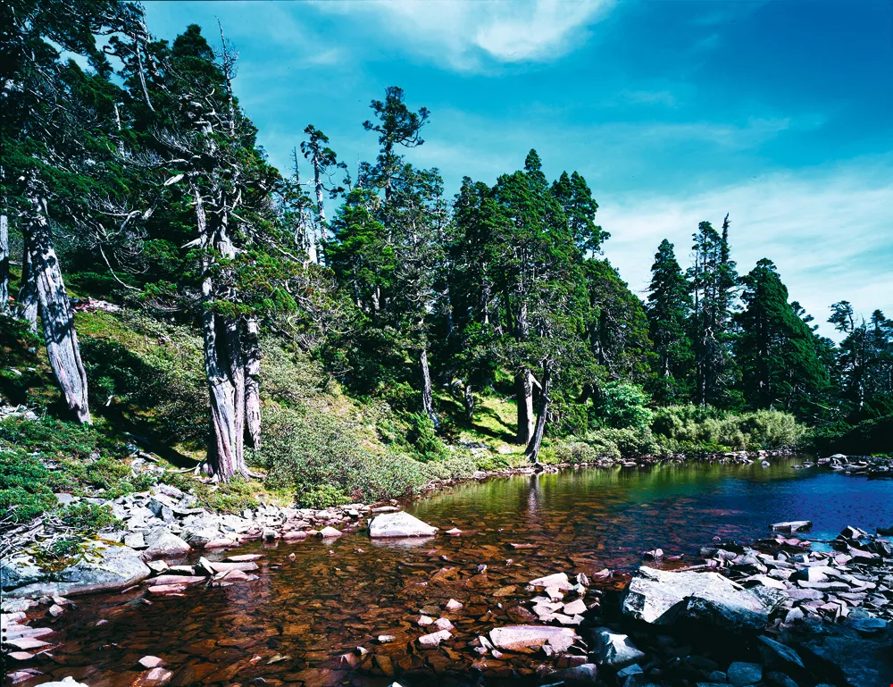
Located to the west of the main peak of Mt. Xue, Cui (Emerald) Lake is a tarn: a pool or lake excavated by a glacier. It is the highest alpine lake in all Taiwan, and its water is so clear that you can see to the bottom.
In 1932 Tadao Kano published the first academic paper about glacial relics in Taiwan. It caused quite a stir: Were those round depressions the result of glacial or fluvial erosion? The matter wasn’t settled until 70 years later when Yang investigated the valleys around Mt. Xue and identified conclusive evidence of glacial cirques, cirque thresholds, and glacial striation. Quaternary glaciation had indeed occurred in Taiwan.
Glacial cirques are mostly located at the tops of alpine glaciers, Yang explains. When snow falls heavily and the resulting ice attains a certain thickness, it exerts pressure on what is below, eventually shaping steep back walls and a bowl- or funnel-shaped concave valley.
Cirque thresholds, the rocky protruding outer edges of cirques, are one of the clearest of glacial landforms and important evidence when determining a history of glaciers. Yang points out that due to topographical variation, a glacier is not uniform in thickness, and thus the downward, excavating force the glacier imposes on the land is also uneven. Where the advancing edge of the glacier is relatively thin, it leaves a protruding lip around a cirque. In the No. 1 Cirque Valley of Mt. Xue, there are six such cirque thresholds.
Glacial striations, on the other hand, are parallel tracks created by glacial debris being dragged over stone surfaces that have been rounded and “polished” by glacial movement. These surfaces can easily be covered over or erased by mudflows, vegetation, or human activity. Yang recalls how he used to make a concerted effort to get off the beaten track when doing his fieldwork. It was on one of these occasions that the weather cooperated to help him spot one of these glacially striated surfaces of bedrock.
Yang had been carrying out fieldwork in the Nos. 1 and 2 cirque valleys, where he had found evidence of glaciers such as cirques and cirque thresholds. But much to his dismay, he couldn’t find any evidence of glacial striation. But then the heavens came to the rescue with a timely downpour. As he hustled to a shelter in the dark forest, he suddenly saw an expanse of shining rock that the rain had cleaned of mud. The parallel grooves were suddenly easy to see.
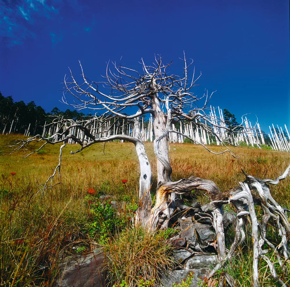
Stands of dead Taiwan firs are a common sight on Mt. Xue’s cirque valleys. Set off by blue sky and lush green slopes, they look just that much more magnificent.
With the vast expanses of time involved, glacial relics may seem merely of academic interest, but when you consider them from the angle of global climate change, they suddenly become quite relevant to the here and now. Yang points out that these landscapes were shaped by dramatic swings in climate that occurred over hundreds of thousands of years. “It’s estimated that Taiwan was even warmer 7000–8000 years ago than it is today.”
Our world has experienced three ice ages during the pre-Cambrian, the Paleozoic, and the Cenozoic eras when the temperature steadily fell. Taiwan last experienced glaciers 70,000–10,000 years ago during the Pleistocene Epoch, the sixth epoch of the Cenozoic Era and the first of the Quaternary Period. Among the glacial relics from that time period, cirque valleys are the most beautiful.
In all the areas straddling the tropics of Cancer and Capricorn, including islands such as Madagascar, only Taiwan, due to its numerous peaks over 3000 meters, has glacial relics. Spanning subtropical, temperate and frigid climatic zones, with elevations ranging from low to alpine, Taiwan has five different climatic ecosystems. It’s truly unique.
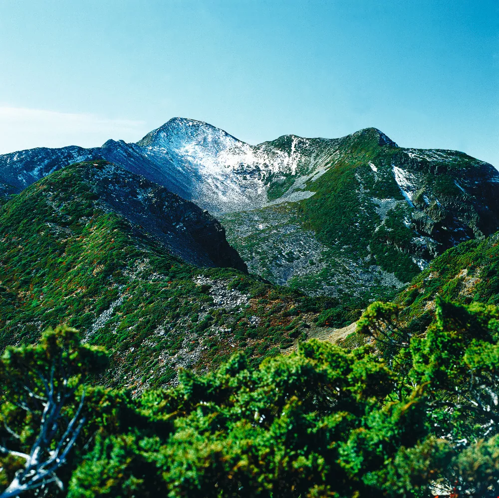
The funnel-shaped No. 2 Cirque Valley of Mt. Xue is a relic of Quaternary glaciation.
Setting aside the question of whether these valleys are really glacial relics, there is no debate over their rare and stunning beauty.
A thousand meters long and 600 meters wide, Mt. Xue’s No. 1 Cirque Valley is located to the northeast of the mountain’s main peak, in the Heping District of Taichung. Open to the northeast, with a lowest elevation of 3500 meters, it has an elongated oval shape and is the largest and most complete example of a glacial cirque in Taiwan. Based on measurements of the cirque’s central axis, Yang calculates that the glacier here was some 200 meters thick and four kilometers long.
Largely metamorphic with a high quartz content, the rock strata of Mt. Xue are extremely hard. The No. 1 Cirque Valley has a slope of 30–35º. At the end of the glacial cirque there is also a curving sloped glacial carved valley that is much wider than a typical river valley at this elevation in Taiwan.
The cirque is full of fir trees, as well as beautiful low-growing Yushan rhododendrons and Yushan junipers. The valley bottom and slopes are littered with rock debris. Some argue that avalanches are responsible, but Yang supports Tadao Kano’s contention that they are the result of frost weathering that caused geologic fracturing and collapse.
Mt. Xue’s No. 2 Cirque Valley is the highest such valley in Taiwan. Located on the northern face of the mountain, administratively the cirque is part of Miaoli County’s Tai’an Township. Open to the north, the oval valley is 600 meters long and 400 meters wide. At its lowest point, it has an altitude of 3630 meters. Rock debris has settled along its walls to create a 35º slope. There are many scattered rock fragments along the valley bottom, as well as some larger piles of debris that some scholars hypothesize are terminal moraines.
Shangcui (Upper Emerald) Pond on Mt. Xue is actually the mountain’s No. 5 Cirque Valley. Water accumulates to form a pond here during the rainy season. At an elevation of 3520 meters, the No. 7 Cirque Valley, source of the Xueshan and Da’an rivers, is located one kilometer from the rocky slope beneath the west ridge of the mountain’s main peak. Because the lake here holds water year round and is at a slightly lower elevation than Shangcui Pond, it is known simply as Cui (Emerald) Lake. It is the highest alpine lake in Taiwan.
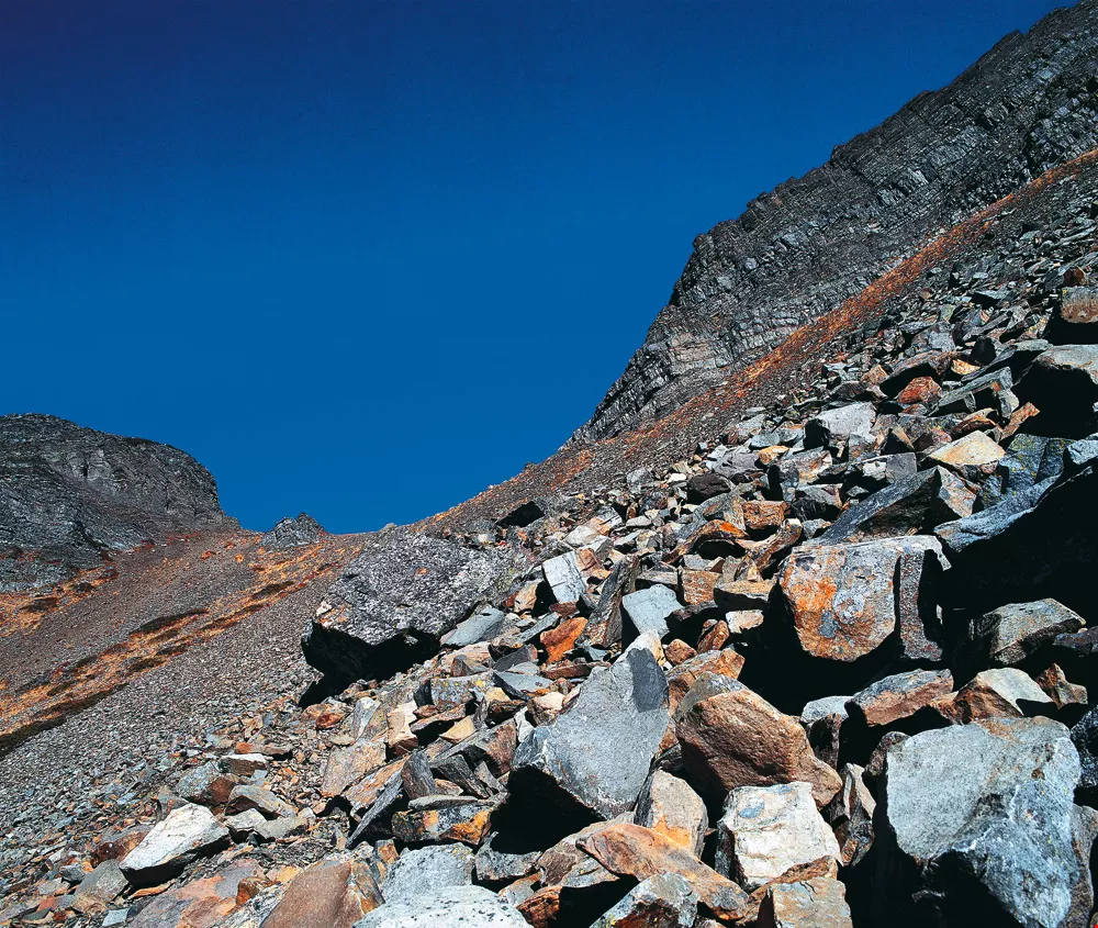
Glacial and wind erosion led to collapses that scattered rock fragments on the slopes and bottom of Mt. Xue’s cirque valleys.
Those who have seen these beautiful cirques with their own eyes are always bowled over by their magnificence.
Wuling’s four peaks (Mt. Tao, Mt. Chiyou, Mt. Pintian, and Mt. Kalaye) are all ideal for observing Mt. Xue’s No. 1 Cirque. One need climb only to an altitude of 2800 meters to get a clear view of the entire valley.
Every year from December to April, when snow falls on Mt. Xue, the cirque valleys become snow covered. According to the Interpretation and Education Section of the Shei–Pa National Park Headquarters, typically several hundred people are climbing Mt. Xue on any given day. All they need to do is to turn around every once in a while to get a good view of the cirques. No. 1, which is easiest to recognize, can be seen as soon as you walk out of the dark forest. No. 2 can be seen in its entirety from Mt. Xue’s northern peak.
Glaciers once occupied Taiwan’s highest ground. If you are a fan of beautiful landscapes, then come to Mt. Xue to see for yourself the magnificence of the glacial cirques they left behind.

@List.jpg?w=522&h=410&mode=crop&format=webp&quality=80)

@List.jpg?w=522&h=410&mode=crop&format=webp&quality=80)


