Filling the Gaps in History --Nelson Yang, Expert on the "Old Trails"
Chang Ching-ju / photos Vincent Chang / tr. by Robert Taylor
March 1994

He's afraid to change a blown light bulb at home; in fact, he's afraid of all electrical appliances. He says cars are deadly weapons, and never drives one unless he really has to. His other half shakes her head and says she doesn't know how many times she has shown him how to use something as simple as a pager.
But he has been criss-crossing Taiwan's mountains for more than 30 years, was only the seventh person to climb all of the "100 Peaks"--Taiwan's mountains over 3000 meters--and has conquered many ascents which other climbers feared to tackle. Nelson Yang, who feels more at ease in the mountains than on the plains, is an expert on Taiwan's "old trails" who wishes to fill in the gaps in the history books. He is probably more familiar with the high mountains which cover three-quarters of Taiwan's area than he is with the streets of Taipei, where he has lived for more than a decade. . . .
In 1986 he completed the first survey since Taiwan's return from Japanese to Chinese rule of the entire western section of the old Hehuan Trail, which was built under the Japanese occupation, following the course of hunters' tracks. In 1987, he finished a survey of the western section of the Ching dynasty Patungkuan Trail over Mt. Yushan, and uncovered many sections of well-preserved Ching stone paving. At the site of a Ching military camp, he collected numerous fragments of blue and white porcelain crockery, which were identified by the National Palace Museum as products of the Dehua kiln in Fujian Province.
After that, he ventured into the even more difficult terrain of the Central Mountain Range, and searched out the eastern section of the Patungkuan Trail, which is classed as a Grade 1 historical monument. Six years ago, the Yushan National Park authorities cleaned up part of the Japanese Patungkuan trail, but the older Ching dynasty trail remained hidden from human view until, in the course of 30 trips into the mountains, he finally unlocked its secrets. . . .

Nelson Yang (far left), Hsu Ju-lin and a party of good friends on a trip to Mt. Yusuei on the upper reaches of the Laonung River to visit Tamaho, where the "unconquered savages" of the Bunun tribe made their last stand against the Japanese. (courtesy of Nelson Yang)
on the front line
During the Ching dynasty and the Japanese occupation, to provide access to Eastern Taiwan, soldiers were sent to cut 30 or 40 paths through Taiwan's mountains. Some of them are now the routes of today's highways, but the majority long ago became overgrown, and faded back into the mists of the enigmatic mountains. It is only recently with burgeoning interest in research into Taiwan's history that the national parks, in order to seek out relics of culture and history within their boundaries and to provide hiking trails for visitors, have begun working urgently to seek out these old trails. But the old trails run deep into the furthest recesses of the mountain ranges, and were often cut along hunting trails and the tracks worn by wild animals, so that they are difficult for most people to reach, and with little in the way of historical records, searching them out is an extremely difficult task.
This is why, as Nelson Yang has walked one after another of the long-abandoned old trails, he has gradually come to been seen as an "expert," and many people would like to know how he managed it. But he stresses that seeking out the old trails is simply one part of the expression of his idea that "to understand Taiwan, you have to walk into Taiwan's history." His reasons for hunting down the old trails are intimately bound up with the course of his mountain climbing career.
While most climbers aim for the peaks, 30 years ago Nelson Yang started "blazing a different trail." When he went climbing, he not only armed himself with maps showing contoturs and ridge lines, but was also guided by information on Taiwanese culture and history from countless books apparently unconnected with climbing.
For instance, when he read the history of how the Japanese tried with a mixture of cajoling and military suppression to overcome the "last unconquered savages," the Bunun of Wushe, or of how after Japanese massacres using poison gas and machine guns, the Atayal chief Monardao finally led 200 of his tribespeople in a mass suicide at Mahebo Caves, the stories made a deep impression on him. He noticed that many of the places mentioned in the historical records were ones he had seen on the map, and so he thought that as written texts are only part of historical evidence, and he himself being a climber, it would be a good idea to use his own two legs and his own two eyes to go to these places himself to look, reflect and investigate, or just to close his eyes and imagine, and thus to personally walk into history.

Before actually venturing into the mountains to search for the old trails, Nelson Yang first goes to interview people in the mountain tribal settlements along its route. Here (below) he is asking for information about the path from an aboriginal familiar with that area of the mountains, with the aid of a contour map (opposite).
Moving mountains
Years later he finally visited what for him was the hallowed ground of the Mahebo Caves. "When I stepped into the forest and was immediately enclosed by its gloom, with the damp air all around bearing the scent of decaying wood, I felt an insuppressible surge of excitement welling up inside me. Months of planning and years of longing were about to be realized. . ."
With the passing of time, two of the caves where Monardao, leader of the Wushe Incident, finally committed mass suicide with his tribespeople rather than surrender, had been blocked off by tree roots and fallen rocks. Because of its grisly past, the remaining third and largest cave was rarely visited except by the occasional passing hunter, and this site buried deep in the forest, a witness to the history of resistance to the Japanese, had been almost completely forgotten. When Nelson Yang found the caves and wrote his "Remembering the Fallen Heroes of the Mahebo Caves," history was reawakened.
While reading old texts about the aboriginals of Southern Taiwan, he came upon the story of a tribe called the Suqaroqaro, who were well known for a while but later completely disappeared. At the time of the Mutan Incident in 1874, when Japan used major military force against Taiwan for the first time, Jagarushi Guri Bunkiet (Pan Wen-chieh), the chieftain of the Suqaroqaros' Terasok settlement, played a mediating role between the Japanese forces and the local aboriginals. Each time the Japanese attacked the "savage villages," Bunkiet would step bravely forward to try to resolve the conflict by peaceful means. The more often Nelson Yang saw Bunkiet mentioned in historical records, the more he was attracted to him.
Yang went to the site of Terasok settlement in the mountains of Southern Taiwan to look for Bunkiet's old home and collect information, and he sought out the wife of Bunkiet's grandson, now in her nineties. The history of the Suqaroqaro is rarely mentioned in literary works, and historical records are sparse too, but the essay which Yang later wrote on the subject, entitled "A Tale of the Suqaroqaro," not only won a prize as a piece of reportage literature, but was also used as a course book by the history department at Taiwan University .

(below) Thanks to Nelson Yang the Patungkuan Trail, long overgrown and forgotten, has finally been rediscovered. Here members of the search team have cleared away the vegetation to reveal a well-preserved section of the path. (courtesy of Nelson Yang)
Over the hills and far away
Just as in the song which goes "Over the mountains is where I want to be," for the inquisitive Nelson Yang, what lies beyond the mountains holds an enormous attraction. Most climbers park their car at the foot of the trail and return to it by the same route, but for Yang, who never likes to tread the same path twice, to do so is an annoyance. "I don't like to go from A to B and then back to A, I like to go from A to B and then to C," he says.
While other climbers are hurrying along the paths of Mt. Nanhu, passing carelessly by the Nanhu glacial terrain which they have probably only vaguely heard of, Nelson Yang follows in the footsteps of the biogeographer Tadao Kano who discovered the glaciated landscape during the Japanese occupation, searching out one by one the cirques described in Kano's articles and sketch maps.
"Looking on the positive side, you could say that I'm someone who follows his ideals, or from a negative angle you could say I'm a troublemaker." He was expelled from his church senior high school for questioning the school's rule that everyone had to attend prayers. When he was studying at Taiwan University's foreign languages department, dissatisfied with the way that prose literature classes merely consisted of going through texts with a dictionary without any real critical discussion of the works' artistic and rhetorical merit, he would often get into arguments with his teachers, and because of this was always given fail marks. After he graduated, he changed jobs constantly.
"I like to get my own way, and I'm not at all docile, so it's not easy for me to settle down to some job or fit in with a humdrum existence. When you live with other people, then you have to live by their rules to some degree." He says that perhaps his passion for mountain climbing is a reaction against everyday life. When somebody of this character hikes into the forests and up the mountains, he will naturally not be content to follow the same beaten path as other climbers.
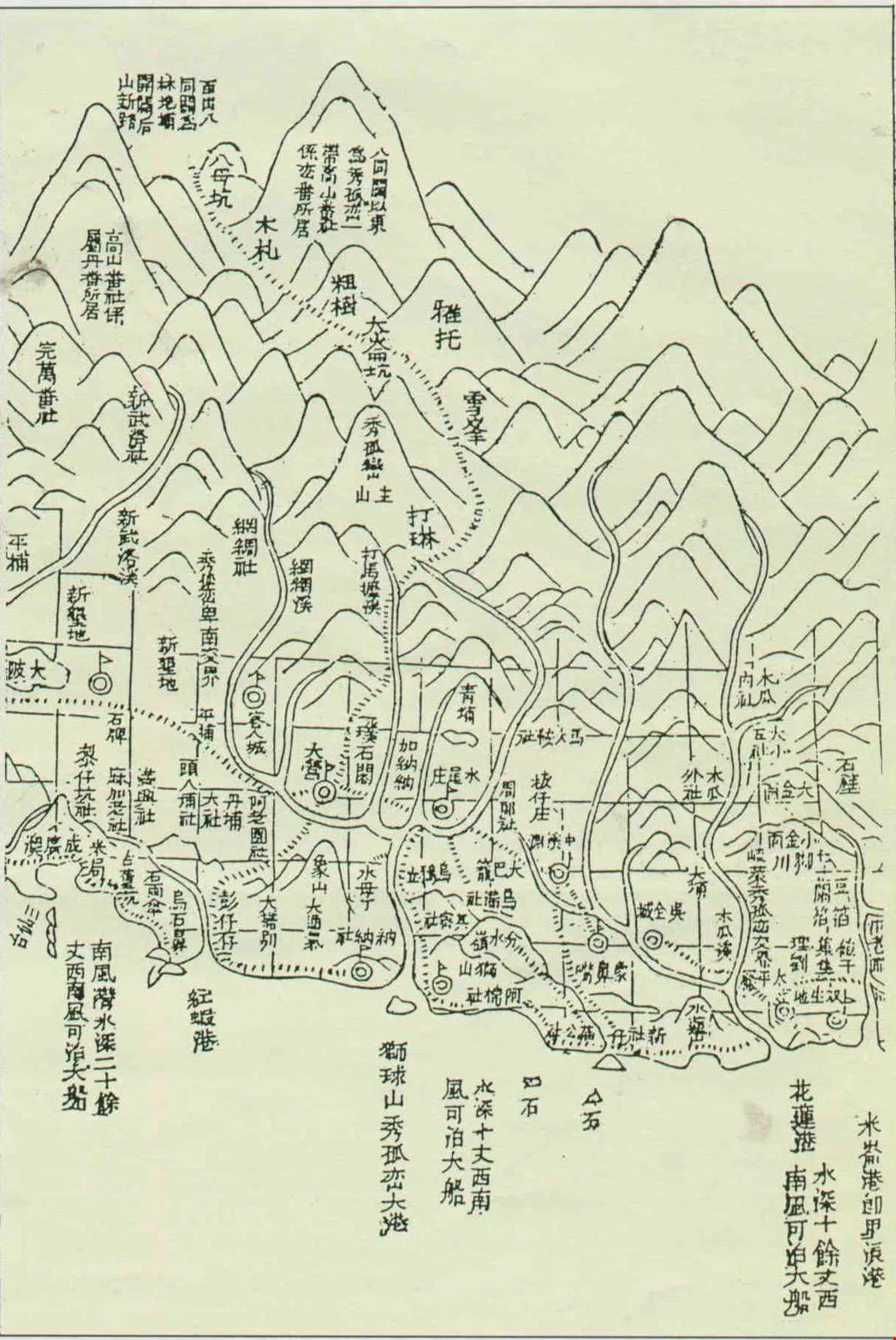
The map of the old Patungkuan trail (opposite) in a Ching dynasty atlas of Taiwan is no more than an outline sketch, and does not show watercourses or ridge lines, so that it is of no practical use for finding one's way in the mountains.
History's y-axis
Today, he doesn't like to say much about his past achievements of climbing the 100 Peaks and opening up new climbing routes. Although he was the first to scale many peaks, and his descriptions provide much useful information for other climbers,he says "Oh my, who was first up which mountain, whose feet where the first to touch the peak,who climbed fastest--these are all just about physical strength." For him, the richness of Taiwan's mountain ranges by no means lies only in their unique geography. Everywhere where climbers go today, others have probably gone before.
"Taiwan's history is not all centered on the Western plains. The aboriginal peoples have been living here for thousands of years." He says that human activity in Taiwan has a vertical distribution from ancient to modern times and from high to low. Even the highest mountains show traces of human presence. Although the mountains which cover three-quarters of Taiwan may seem empty, in fact they conceal an inexhaustible wealth of history. And it is only by going to the "front line" that one realizes that this is the original face of Taiwan, which really exists although many people have never come into contact with it.
Combining moutaineering with academic study and "walking into history" is Nelson Yang's climbing philosophy. He has explored old aboriginal tribal settlements, sought out the sites of the Tafun, Wushe and Mutan incidents, stood in reverie on ancient battlefields, walked hunting trails, animal tracks and tribal paths, surveyed the Peipo tribe, and explored the sacred places of the Rukai people around Lake Daloparin (Great Spirit Lake) and Lake Bayu (Little Spirit Lake). From books and historical records he has got to know many adventurers who explored the mountains in bygone days, and has retraced their footsteps to gain a closer understanding of this land.
Associate Professor Wu Mi-cha of Taiwan University's history department feels that among the scholars researching Taiwan's past, there is a sore lack of such "men of action."

Although the traces of the old trails in the high mountains are not easy to find, in lower mountain areas human activity makes them disappear all the faster. Shihtou Ying (Stone Fort), which once stood at Sheliao in Pingtung County, marked the start of the old Chinshui Fort trail, and troops of the Ching army were once stationed here. But now the site has been turned into fields, and only a short row of foundation stones remains.
Academic mountaineering
But researching all the historical sites in the mountains is not a task one person can complete alone. This is why Yang constantly uses his influence in climbing circles to promote "academic mountaineering" among climbing organizations.
"Geographical exploration can strengthen one's knowledge of history, and by the same token, if one ignores history and does only geographical surveying, than one will never grasp the true purpose of geographical exploration." The young people who go to his home to spread out maps and mark out mountain areas containing native settlements or unusual geography or geology, are no longer simply competing to conquer mountain peaks, but instead are surveying bit by bit the ancient tracks, historical and archaeological sites, and flora and fauna.
In the course of his climbing activities Nelson Yang has got to know many members of the aboriginal tribes, and he encourages them to return to their old tribal settlements to see them with their own eyes, and not just to get their knowledge of such events as the Wushe Incident or the Mutan Incident from history books or simply repeat what they have heard from others. He believes that for a complete reawakening of aboriginal culture to take place, tribe members must themselves take the time to understand their own clan structures, myths and traditions. Thus when Bunun tribe members recently returned to their old lands, they specially invited him along, because he understands them just like a brother.

At the same time as Nelson Yang was exploring the old Ching trail, he also explored the trail which the Japanese built to keep the aboriginal peoples under control. Pictured here is the site of a Japanese police outpost at "Tsutsuji," 'a point where the Ching trail and the Japanese trailcrossed. Nelson Yang and Hsu Ju-lin are seen measuring the height of a retaining wall. (courtesy of Nelson Yang)
Dogged digging
Ten years ago, when the National Parks were planning to uncover the old trails, they saw Nelson Yang as the best candidate for the job.
The search for old trails often starts from scratch, and his characteristic traits of never being satisfied, of inexhaustible curiosity, of never believing he has read enough on a subject, and of always wanting to experience things for himself, enabled him to fill in many gaps in Taiwan's history books.
Taking the Ching dynasty Patungkuan Trail as an example, even though it was the most important route across the mountains in Ching times, its builder, commander Wu Kuang-liang, left no account of its construction, and it was built so long ago that few other records remain. The Ching map drawn 120 years ago is in the style of a freehand landscape sketch, so that it is of almost no use to today's climbers, and the old names marked on it have all changed.
"I'm a great fan of whodunits," says Nelson Yang, who as a schoolboy once read almost a hundred stories by Gardner, creator of Perry Mason, in one go. For want of historical records, one must start from scratch, searching high and low, and where there are no clues one simply has to find some. But the test of scholarship is in answering questions, and the space beyond the question mark gives unlimited scope for ingenuity. Yang believes that if one only searches carefully, one can find the answer to everything.
From then on, every morning he would be standing outsides libraries or the National Palace Museum when they opened, and at midday would ask permission to stay through the lunch break, skipping lunch himself. Little by little, he filtered snippets of information from the monthly despatches sent from all over China for the perusal of the emperor and high military commanders (these records were brought from the mainland when the ROC government withdrew to Taiwan). Sifting through the thousands of old files, he would often find just a couple of sentences of relevant information. He also looked at virtually all the surviving topographical survey maps and maps showing the "savage villages" from throughout the Japanese occupation, and then began matching up all these clues as if piecing together a jigsaw puzzle. This investigation took him a year and ten months from beginning to end, and whenever he had time he would be busily searching for materials.
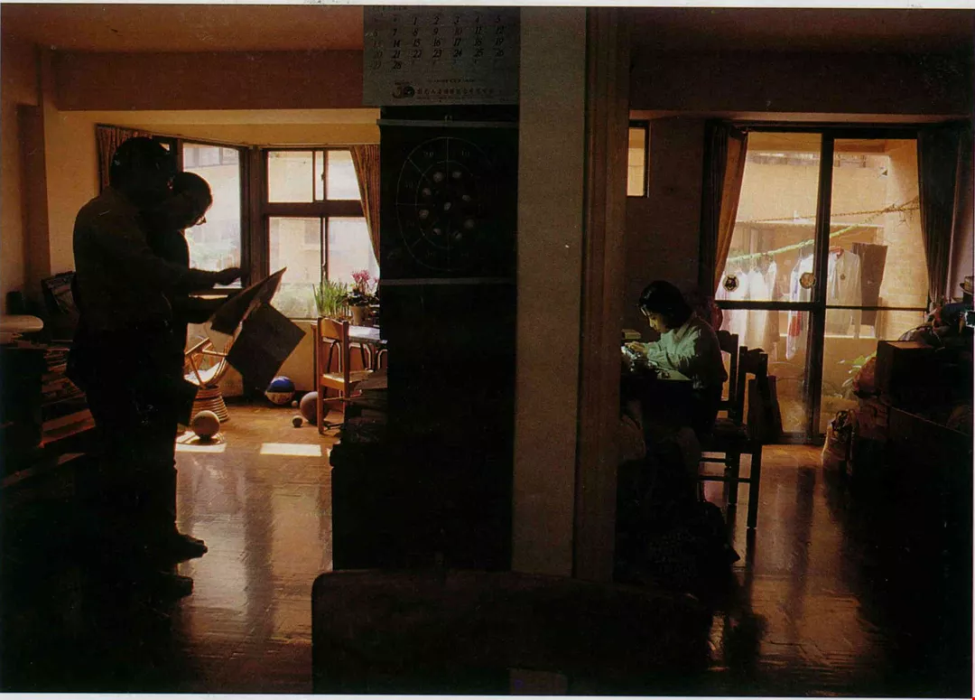
To help him "walk into history," Nelson Yang reads all kinds of books, magazines and articles on Taiwan's past. His small lounge is where he usually does his "homework." His daughter too has been infected by his love of studying.
Historical detective work
The place names mentioned in the historical records are all different from those seen in modern writings and marked on maps, and even from those used by hunters. Some of the names which appear frequently in the Ching records were important outposts along the trail, yet try as he might he could mind no clue as to their location. "Trying to match place names to the map was like trying to decipher a secret code," he says.
Although no record can now be found of many stages of the trail's construction, Yang and his companions were nonetheless able to find many valuable remnants: the sites of military camps, stone steps, memorial stones commemorating the trail's building, and even porcelain bowls used by the Ching troops and sake bottles left behind by Japanese soldiers.
Past texts have often spoken of the Ching trail and the Japanese trail as if they were one. Where the Ching trail could not been seen they say "here the Japanese trail follows the path of the Chingtrail." But Nelson Yang's survey showed that although the two trails cross in many places, they never follow the same route.
"A lot of people seem to think we were lucky, just like finding money walking along the street," says Yang's wife Hsu Ju-Lin, who often accompanies him on his climbing expeditions. But in fact they used the simplest of methods, making blanket searches, putting one foot in front of the other, trying to find ways through, slowly adding one little section after another. Each time they would keep going until they had eaten all the food in their rucksacks or used up all the days they had taken off work, before they would go back down the mountain.
"It's just like panning for gold, you might find something only one time in a hundred," says Hsu Ju-lin.

Before he retired, Nelson Yang would spend all his holidays and weekends in the mountains, but now he finally has time to spend part of the winter holiday taking his son and daughter to visit the Tungshan River in llan County.
Ask the trees
Between today's mountains and the old trails, when the way ahead is unclear and uncharted, where do you find water? Where do you find a place to camp? What is the terrain like? No-one can tell you. On the eastern section of the Patungkuan trail, Yang and his companions sometimes spent up to three days without water, and they quenched their thirst by drinking the water inside succulent vines and by using their gloves to soak up the morning dew off blades of grass. Among the loose, brittle rocks and the giddy precipices of Taiwan's mountains, they would sometimes progress no more than three to five hundred meters a day, and had to be mentally prepared to lose their way at any time. "Whenever the path ran out and we found ourselves clinging to a sheer cliff hardly able to go forward or back, I would always think to myself, it's a good thing we're insured," says Hsu Ju-lin, who was once hit on the forehead by a falling rock which left her face covered in blood. She says it's a miracle they haven't both been killed.
"In Taiwan's unstable terrain, many sections of the old trails have long disappeared, and there is no sign of human activity. But in actual fact Japanese alder, makino bamboo, geometrically-shaped patches of the grass Miscanthus sinensis or artificial piles of stones are all giving you hints," says Nelson Yang, who is completely engrossed in his search for the old trails.
The trees and grasses cannot speak, but the passage of humans is sure to leave behind "evidence." For instance, people are apt to choose a flattish area open to the sun in which to live, so in a place like this there might be a good chance of finding a fort; where there is plentiful sunlight and water, there may be land which has been cultivated; in virgin forest, you won't suddenly find a large patch of cogon grass: somebody must have once cut down the trees here, and you may stumble across abandoned fields or the remains of a tribal settlement; the Japanese liked to plant flowering cherries, gingko, bamboo or Formosan sweet gum around where they lived, so if these trees appear in an environment where there are not normally found, it may be a sign that a Japanese police post once stood here.
Enough for three lifetimes
Whenever the news of another old trail's rediscovery is published, many people will ring up and ask, "Which book did you find the information in? Can you tell us the title? Where can we buy it?" Nelson Yang doesn't quite know where to start explaining. One report says simply "After scaling a bank by a stream and crossing three small ridges, the path finally arrives at [the Bunun] Ronkaiban settlement [in the Central Mountain Range]." But it would take three days and three nights to explain how they actually went about finding it.
Nor does he have time for such reminiscing, because he still constantly goes up the mountains. Although he is already 63, he wants to keep on walking as long as his legs will carry him. At the moment he is busy translating materials from the time of the Japanese occupation, tracking down historical sites, and searching out old trails, but there are simply not enough hours in the day. "I wish I was 20 years younger," he says. Before his retirement, at Chinese New Year and other holidays he would be off into the mountains. Hsu Ju-lin says, "Nobody's as crazy as him." But because his conscience nagged him, his son and daughter would always receive extra thick red envelopes of New Year money.
Even the children would often ask, "Daddy, haven't you climbed lots of mountains? When will you have climbed them all?" But their father's reply was " Three lifetimes wouldn't be enough." He says that with so many traces of the past to be found, the search is too much for one person, and so when he walks the old trails he usually takes along aboriginals, students, or some of the few friends who share his concept of "academic mountaineering."
His other half, Hsu Ju-lin, is one of them. At the age of 19, Hsu Ju-lin once walked the difficult route from Mt. Nanhu to Central Peak alone. As a member of her college climbing club she had read many of Nelson Yang's accounts of his climbs. She under stood his ideals, and went climbing with him full of enthusiasm and lofty aspirations.
"In the teeth of a stiff mountain breeze, we stood at the end of the western section of the old trail. . . 112 years ago, had Wu Kuang-liang stood here too, gazing out across peak after peak among a swirling sea of clouds, searching for the route which would carry him eastward? Were our hopes and determination any less than his? Had not we too sought out the trail through Tashuiku [the trail's highest point] by our own efforts?" wrote Hsu Ju-lin in an article published after their survey of Patungkuan Trail was completed.
A spiritual adventure
Even so, Hsu Ju-lin has urged Nelson Yang, "Don't take on any more old trail projects." She says Yang is motivated by a deep sense of crisis, feeling that the native peoples' cultures and languages are disappearing, and that in the search for the old trails there is almost nothing to go on. The goals he sets himself are very high, and this puts him under great psychological pressure.
"I believe quite firmly that whenever I go into the mountains, apart from the physical adventure, there is also a mental challenge. Of course it's nice to curl up with a travelogue and to journey with your imagination, yet if you can transcend the bounds of time and space and converse with the people of past days in their own place, it takes more out of you, but the spiritual plane which you can reach is also a very high one," says Yang.
The knowledge of culture and history which he has amassed over the years has made his exploration of the old trails more then just a mechanical search. He likes to "walk into" the history all along their path. A few simple or harsh words in the records will prompt him to ponder endlessly and search for the real and moving story behind them, so that they are no longer just dead words on a page. Through his curiosity and persistence, the old trails seem to take on flesh and come alive in his mind.
Today, as more people are getting involved in the search for the old trails, Nelson Yang on the one hand hopes that even more will participate, but also fears that this is just a superficial manifestation of a fashion for things Taiwanese. "Walking the old trails is a kind of cultural exploration. Apart from simply locating the historical sites along them, one should also look back at the human and geographical features along the way which people have missed in the past. It is only if people can look from a wider perspective that this so-called 'movement' can develop into something lasting."
[Picture Caption]
p.116
Along the mountain trails which climbers walk along today, there are many traces left by people of bygone years. This photo was taken in 1937 by the Japanese photographer Koyo Okada, and shows Atayal tribe members climbing Hsuehshan from Sikayo settlement. (courtesy of National Central Library Taiwan Branch)
p.117
Nelson Yang (far left), Hsu Ju-lin and a party of good friends on a trip to Mt. Yusuei on the upper reaches of the Laonung River to visit Tamaho, where the "unconquered savages" of the Bunun tribe made their last stand against the Japanese. (courtesy of Nelson Yang)
p.119
Before actually venturing into the mountains to search for the old trails, Nelson Yang first goes to interview people in the mountain tribal settlements along its route. Here (below) he is asking for information about the path from an aboriginal familiar with that area of the mountains, with the aid of a contour map (opposite).
p.120
(below) Thanks to Nelson Yang the Patungkuan Trail, long overgrown and forgotten, has finally been rediscovered. Here members of the search team have cleared away the vegetation to reveal a well-preserved section of the path. (courtesy of Nelson Yang)
p.121
The map of the old Patungkuan trail (opposite) in a Ching dynasty atlas of Taiwan is no more than an outline sketch, and does not show watercourses or ridge lines, so that it is of no practical use for finding one's way in the mountains.
p.122
Although the traces of the old trails in the high mountains are not easy to find, in lower mountain areas human activity makes them disappear all the faster. Shihtou Ying (Stone Fort), which once stood at Sheliao in Pingtung County, marked the start of the old Chinshui Fort trail, and troops of the Ching army were once stationed here. But now the site has been turned into fields, and only a short row of foundation stones remains.
p.123
At the same time as Nelson Yang was exploring the old Ching trail, he also explored the trail which the Japanese built to keep the aboriginal peoples under control. Pictured here is the site of a Japanese police outpost at "Tsutsuji," 'a point where the Ching trail and the Japanese trail crossed. Nelson Yang and Hsu Ju-lin are seen measuring the height of a retaining wall. (courtesy of Nelson Yang)
p.124
To help him "walk into history," Nelson Yang reads all kinds of books, magazines and articles on Taiwan's past. His small lounge is where he usually does his "homework." His daughter too has been infected by his love of studying.
p.125
Before he retired, Nelson Yang would spend all his holidays and weekends in the mountains, but now he finally has time to spend part of the winter holiday taking his son and daughter to visit the Tungshan River in llan County.

@List.jpg?w=522&h=410&mode=crop&format=webp&quality=80)


