Alangyi Historic Trail:The Battle for Conservation
Yeh Pin-yu and Teng Sue-feng / photos Yeh Pin-yu / tr. by Chris Nelson
May 2012

It’s a place that bears the footprints of centuries of migrating people, the spirits of those who bravely resisted invaders, and the faint roar of pounding surf. It’s a place battered by typhoons and monsoons, with precipitous coastal cliffs carved by rushing rivers and beaches strewn with stones rubbed smooth by churning waves. It’s a place of world-class geological vistas.
This is one of Taiwan’s only two remaining sections of natural coastline, Taiwan’s remotest corner: Alangyi.
The Chinese name Alangyi is derived from the Paiwan-language place name Aljungic. During the past several centuries years, this trail was walked by people traversing Taiwan’s southwestern plains, the Hengchun Peninsula and the area between Taitung and Hualien.
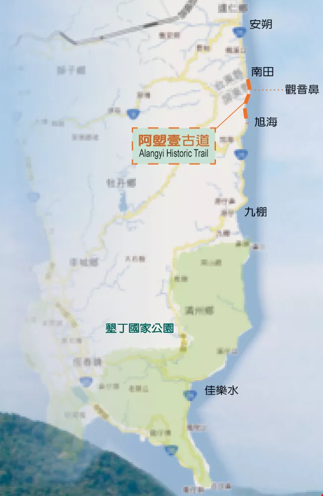
Alangyi Historic Trail is a north-south route stretching about 12 kilometers northward from Xuhai Village, Mudan Township, Pingtung County to Nantian Village, Daren Township, Taitung County. Currently, it’s almost the only stretch of Taiwan’s coast not reached by modern highways. However, the Directorate General of Highways (DGH) carried out an environmental impact assessment in 2002 with a view to extending Highway 26 into this area, in order to complete the highway system encircling Taiwan.
But the public reacted strongly, fearing the disappearance of one of Taiwan’s last stretches of unspoiled coastline. In 2006, the Pingtung Environmental Protection Union launched a movement in opposition to Highway 26, gathering the support of tens of thousands, including academic and artistic groups, and Alangyi Historic Trail was transformed from a little-known section of the coast into a focal point for the news media.
Environmental groups rallied their forces to fight development and preserve nature. However, local residents had different views. Xuhai Village is a small fishing and farming town known for its hot springs, but a population exodus has gradually led to a decline in the last couple of decades. Residents see the opening of this road as an opportunity for growth, and eagerly await the prosperity it will bring.
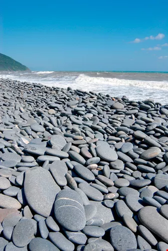
Countless black stones have been scoured smooth by the pounding surf.
Many major historic events have taken place along this trail.
During the reign of the Kangxi Emperor (1661–1722), when the Qing court launched a punitive expedition against the rebel Zhu Yigui, the imperial troops used this route. In 1721, Zhu, who came from what is now Kaohsiung, proclaimed himself the heir to the Ming throne and led a revolt against the oppressive magistrate of Taiwan, successfully taking the capital. The Qing government counterattacked, sending troops across the strait, capturing Zhu Yigui and routing the rebel forces.
In 1871, a Ryukyuan ship was wrecked off the coast of Taiwan near the community of Mudan in present-day Pingtung County, and soon thereafter most of the surviving crew members were massacred by Aborigines. In 1874, Japan launched a punitive expedition to Taiwan. When the Qing government learned that Japan aspired to occupy Taiwan, imperial commissioner Shen Baozhen was quickly dispatched to Taiwan to handle the situation and negotiate with the Japanese military.
After the Mudan Incident, the Qing government acted quickly to bring an end to the long-held isolated status of eastern Taiwan. They set about building improved defensive and transport systems, opened up new mountain routes to “tame” the “savages,” and expanded the existing route from Langjiao (today’s Hengchun) through Manzhou Township to Bayao Bay, then northward along the Pacific Ocean to Beinan in Taitung County. With a total length of 203 km, the road became the sole official route into this area of southeastern Taiwan, and was used by officials, troops and Chinese settlers.
In the latter part of World War II, the Japanese army blew up part of the old roadbed to prevent American forces from landing at Xuhai, cutting off the route. After that, due to long-term military restrictions, fewer and fewer people used the road. This helped keep the landscape in pristine condition and earned it the moniker “the end of the earth.”
Tree-climbing crab (Selatium brocki).
In the 1970s, Kending, Eluanbi lighthouse at the southern tip of Taiwan and Jialeshui, in Manzhou Township, grew into a vibrant tourist center on the Hengchun Peninsula. Highway 26 was extended from Fenggang to Jialeshui, and plans were made to push the road through to Anshuo in Taitung County to connect to Highway 9, completing a coastal highway system encircling all of Taiwan.
In 1982, plans to establish Kending National Park were announced, including designating 14 km of coastline from Jialeshui to Jiupeng as the Nanrenshan Ecological Protection Area, but local residents kept calling for the road to be improved. The DGH conducted numerous on-site investigations and carried out negotiations with the Kending National Park Headquarters. But the park headquarters, in the name of conservation, vigorously opposed development.
The DGH proposed another development plan in 1999. This time, neither the Chung Shan Institute of Science and Technology, which has a missile testing base in Jiupeng, nor the Ministry of National Defense, which managed a naval firing range in Guanyinbi, Daren Township, raised any objections to the plan based on national security reasons. But the Kending National Park Headquarters held fast to its conservationist stance, not allowing development of the coastal road, but instead agreeing to broaden the existing mountain route (Pingtung Route 200 from Jialeshui to Gangzai). Thus, the two stretches from Anshuo to Xuhai and from Gangzai to Jialeshui remain to this day the only natural coastlines.
The environmental impact assessment for Highway 26 passed in 2002, but the road-building plan was repeatedly delayed. In 2006, the start of construction was officially announced, but as three years had elapsed since the environmental impact assessment, an analysis of environmental change had to be done. This gave environmental groups the chance to assert their influence, protesting and petitioning while carrying out environmental assessments and lecture tours, so that the public would better understand the uniqueness and importance of the trail.
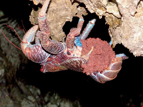
Coconut crab (Birgus latro).
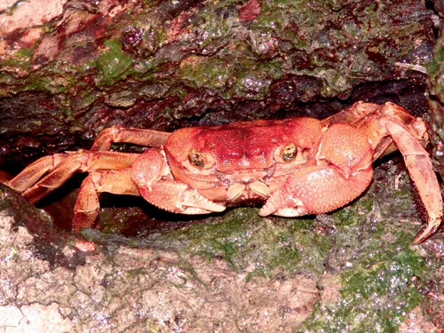
“This is the only place left on Taiwan’s main island where the rare coconut crab and green sea turtle have been sighted. In Nantian, magnificent smooth stones of varying sizes line the dune-swept shores making a gorgeous scene; they’re one of a kind. Numerous natural wild creeks flow out from ravines, telling us that this is a pristine refuge,” describes nature writer Liu Ka-shiang. This is a place of boundless mountains, seas and skies, showing no trace of interference by civilization.
Hung Hui-hsiang, chairman of the Pingtung Environmental Protection Union and initiator of the effort to save the Alangyi Historic Trail, has observed green sea turtles foraging on the coast near Guanyinbi in each of the last three years. Hung thus called for volunteers to clean up the beaches to give the turtles a clean, safe environment to lay eggs. Moreover, environmental assessments have shown that 49 protected animal species, including civets, pangolins and Formosan serow, roam the area, making this a place of rich biodiversity.
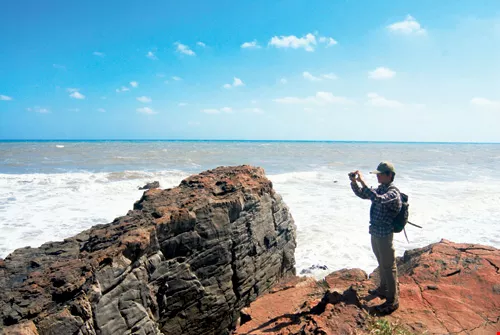
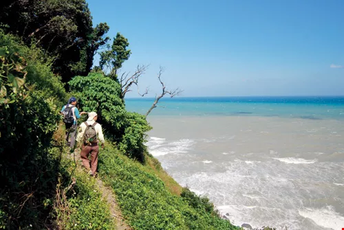
Heading along the undulating coast past rocky beaches and reefs, we encounter a promontory jutting into the sea: this is Guanyinbi. In olden times, people would watch the tides and make their way past the promontory when the tide was out. Now, with rising sea levels and retreating coastlines, there is no direct way to pass it; instead one must climb the surrounding mountain slopes. This 150-meter-high steep slope can be ascended with ropes, and though strenuous, the effort is worth it for the gorgeous mountain and ocean vistas: azure seas and meandering coastlines as far as the eye can see.
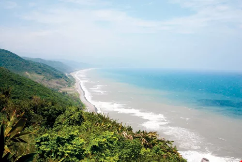
The Pingtung coast is also a national-grade geological classroom. The terrain from Jialeshui to Nantian retains 10-million-year-old geological features, with vestiges of the slump structures characteristic of the continental slope visible everywhere. Geologists say it has the potential to become a world geological heritage site.
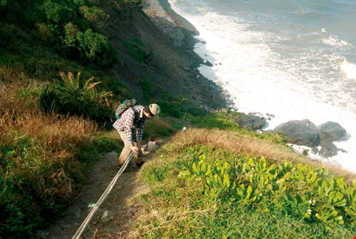
The precipitous heights of Guanyinbi, on the Alangyi Historic Trail, are rugged and tough going, requiring careful climbing with both arms and legs to pass.
In late 2010, Highway 26 passed its analysis of environmental change, and the go-ahead for development was conditionally granted.
Yet in January 2011, as a consequence of the efforts and appeals of environmentalists, the Pingtung County Government, citing a clause in the Cultural Heritage Preservation Act that reads “If any site of natural landscape value is discovered in the course of a construction project or other development project, ... the discovery shall be reported to the competent authority,” forestalled construction by temporarily designating Alangyi as a “natural landscape protected area” for two six-month renewable terms.
Alangyi’s temporary protected status expired on January 18, 2012, bringing advocates of conservation and development to loggerheads. That day, the county government held a committee meeting on the Xuhai–Guanyinbi Nature Reserve. Thirteen out of the 14 committee members present voted in favor of preservation, and the resolution passed. Six years of disputes between advocates of completing the highway and advocates of preserving the Alangyi Historic Trail were thus ended.
However, the land falling under this particular nature reserve plan includes 155 hectares of private Aboriginal land, and according to the Indigenous Peoples Basic Law, the government has to respect the opinions of tribespeople in its policies toward Aboriginal reserve land. That day, many Aboriginal landowners, concerned that their private land would be designated part of the nature preserve, thereby limiting economic development, arrived on the scene to express their opposition. In the end, the county government designated these private lands as a buffer zone to reduce the effect on the landowners.
Pingtung County deputy commissioner Chung Chia-pin notes that the only member of the committee not to vote affirmatively held that the local residents had strong needs for local facilities, but the county government had no plans for them, therefore he voted against. Regarding this, Chung says that the county government will work to enhance local eco-tourism, hot-spring hotel and public transportation resources, thereby satisfying residents’ expectations for business and economic livelihood.
Great reefs created by coastal slumping are visible everywhere along the trail, making it an excellent classroom for studying Taiwan’s geology.
Pingtung Ecological Education Center executive director Chu Yu-hsi laments that Taiwan’s remote areas have long had inadequate medical and educational resources: “Many residents believe that once the road is open, it would take just five minutes to reach Nantian. But in reality it won’t be of any help to solve the medical situation, since there’s no major hospital in Nantian. The county government should work to strengthen basic local resources. We hope the government can reallocate more than NT$3 billion in road-building funds to finance low-carbon community development.”
Oddly enough, after years of contention, Alangyi has finally become a natural landscape preserve. This will attract the attention of even more people to this stretch of coastline. At present, hundreds of people flock here on weekends and holidays, and the Pingtung County Government has yet to implement its restriction of 300 visitors per day. On top of this, the Taitung County Government, which advocates opening the road, doesn’t see eye to eye with Pingtung on conservation matters, leaving a backdoor at the Taitung end wide open. This allows visitors unwitting illegal access to parts of the reserve not managed by Taitung.
Thousand Mile Trail Planning Center deputy executive director Hsu Ming-chien writes that Guanyinbi is geologically sensitive and fragile, and thousands of people walking around here each weekend will be detrimental to the preservation of these world-class natural vistas. A nature reserve isn’t a pleasure ground for the populace: environmental education should be its main role. A solution is for central agencies overseeing cultural assets, such as the Council for Cultural Affairs and the Council of Agriculture, to bring natural landscape preserves under central government control.
He recommends that the Taitung County Government expand the range of the reserve, or develop surrounding communities into “protected areas outside the protected area” for eco-tourism, and provide lodging and meals for tourists at the northern end of the preserve. And highway development funds earmarked by the government could be reallocated to fund the training of eco-tour guides in the two counties, as well as to improve the public transportation and parking facilities at both ends of the reserve.
Taiwan’s populace needs a parcel of land they can get intimate with, where they can take a walk in the woods and commune with the sea. In the bid to transform a low-carbon tourism asset into sustainable tourism income for local residents, Alangyi can be the starting point.
The primordial scenery of the Alangyi Historic Trail, traversing one of Taiwan’s sole remaining stretches of natural coastline, is breathtaking.
The vistas of naturally carved coastline along the Alangyi Historic Trail are a sight to behold. Low-impact development and low-carbon tourism are the best strategies for addressing the living needs of local residents.
The primordial scenery of the Alangyi Historic Trail, traversing one of Taiwan’s sole remaining stretches of natural coastline, is breathtaking.

@List.jpg?w=522&h=410&mode=crop&format=webp&quality=80)
@List.jpg?w=522&h=410&mode=crop&format=webp&quality=80)


