Where the Ocean Meets the Mountains—Qingshui Cliff
Sam Ju / photos Jimmy Lin / tr. by Geof Aberhart
August 2014

The tectonically active Hualien coast is at the front line of mountain formation in Taiwan. Qingshui Cliff is the result of this activity, with colliding tectonic plates pushing up this cliff at the interface between the mountains and the sea. It is eastern Taiwan’s best-known natural barrier, and a showcase of the artistry of nature.
Qingshui Cliff sits between the villages of Heping and Chongde in Hualien’s Xiulin Township, where the mountains meet the sea, and is the only section of coastline in Taroko National Park. In 2013, the cliff was voted eighth on the list of Taiwan’s Top Ten Landscapes, coming in behind Yeliu, Yushan’s main peak, Sun Moon Lake, Jinguashi, Guishan Island, Moon World, and the cirques of Mt. Xue.
The 118-kilometer Su’ao–Hualien Highway passes along Qingshui Cliff. Heading south from Su’ao, this 12-km stretch starts at the Heren Tunnel and ends at the Chongde Tunnel, two of the 12 tunnels along the highway’s course.
With the cliff rising to an average height of more than 800 meters, the journey along the road that runs across the cliff face is a precipitous one—if it had been a vote for “Taiwan’s most heart-stopping landscapes,” Qingshui Cliff would have been a shoo-in.
Taroko National Park guide Lin Maoyao explains that the Taroko area is home to many mountains, including Mt. Liwu, Mt. Qianliyan, and Mt. You’an, but the one closest to the Hualien coastline is the 2,408-meter Mt. Qingshui. It is this mountain’s seaward face that forms Qingshui Cliff.
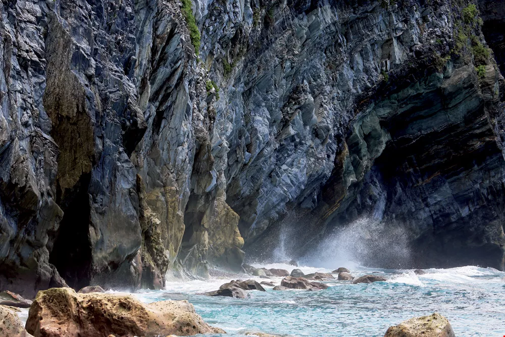
Seen from the ocean, the waves crashing against the rocks highlight the majesty of Qingshui Cliff.
Around 9 million years ago, off what is now the coast of Hualien, the Philippine and Eurasian plates collided, pushing the Earth’s crust up and beginning a process of mountain formation, or “orogenesis,” that gave birth to a number of soaring peaks. Mt. Qingshui was a product of this orogenesis.
Where plates meet we often find cracks, or “faults.” Liou Ying-san, associate professor at National Dong Hwa University’s Department of Natural Resources and Environmental Studies, explains that the peak of Mt. Qingshui is a scant 5 km from the coast, unusually close for such a tall mountain, and that it is “a part that got shunted upward where the fault passed through.”
The upward movement of this side of the fault created an escarpment—Qingshui Cliff. Professor Liou further explains that cliffs like this tend to form in line with the orientation of the fault, meaning that if the fault is steeply vertical, the resulting escarpment will be too.
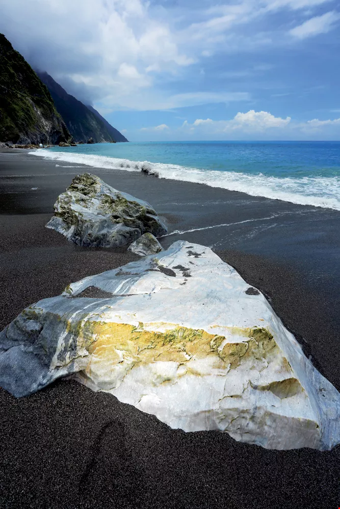
On the beach at the foot of Qingshui Cliff, the marble rocks give off a marvelous, almost other-worldly white glow.
Of course, at the mention of faults one’s mind naturally turns to earthquakes.
On this front, Liou notes that Qingshui Cliff stands at a point where the northward-moving Philippine plate is being subducted under the Eurasian plate, and the area is indeed one of Hualien’s three most quake-prone zones.
The other two are situated in the Pacific Ocean to the east and southeast of Hualien County, and are also connected with fault activity.
Orogenesis and fault activity have shaped the rugged cliffs and mountains of Hualien’s coastline, and it was this geography that left the area cut off from the rest of Taiwan until the 19th century.
Taroko National Park guide Lin Maoyao notes that people of the Shisanhang Culture of 1,200 years ago avoided the Qingshui Cliff area and settled instead in the Liwu River basin. When the Dutch and Spanish came prospecting for gold along the Liwu River, they too chose to bypass the cliff by sea.
After centuries of erosion by ocean waves, Qingshui Cliff’s magnificent rock strata are now on full display, an astonishing example of the wonder of nature.
Much of eastern Taiwan was virtually cut off from the outside world until 1874, when the Mudan Incident led to Qing Chinese imperial commissioner Shen Baozhen being dispatched to Taiwan to “open the mountains and pacify the savages.” The primary element of this effort involved the creation of three major roadways in northern, central, and southern Taiwan. The northern one, now known as the Suhua Old Trail, opened up a route between Su’ao and Hualien. It was only in 1875, when the trail was opened up, that the authorities made their first incursions into the east.
Later, once Taiwan was under Japanese rule, the new regime opened up another route running from Su’ao to Hualien. Finished in 1932, this coastal road forms the basis of today’s Su’ao–Hualien Highway.
These historic routes are still visible today, and offer some great views of Qingshui Cliff.
Seafront spectacleAfter passing through the Heren Tunnel, the Su’ao–Hualien Highway continues on through the Renqing Tunnel, and then the Heqing Tunnel. Liou Ying-san recommends looking to the north or south from the Heqing Tunnel to take in the winding lines of Qingshui Cliff. If the weather’s good, you’ll even be able to see the Liwu River delta, Mt. Meilun, and the Coastal Mountain Range. All told, it’s a spectacular vista.
On top of this, Taroko National Park also offers three trails—Heren, Huide, and Chongde—that go down to the sea. Of the three, both Professor Liou and Lin Maoyao recommend taking the Heren Trail, which starts just north of the Heren boundary marker at the entrance to Taroko National Park.
This trail runs about 160 meters down to the shore, where you will be greeted by a gravel beach and wonderful sea caves.
As you approach the cliff face, veins of quartz reveal themselves, winding through the gray rock like long white scarves.
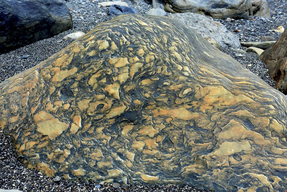
Centuries of polishQingshui Cliff is primarily made up of green schist, gneiss, and marble, and the cliff’s rocks can be dated to as far back as 250 million years ago.
Many places in Taiwan feature these rocks, says Liou, but only at Qingshui Cliff are they so clearly visible, thanks to the centuries of erosion and exposure the near-vertical cliff has experienced.
Tourist cruises and whale-watching boats between Hualien and Su’ao offer especially fantastic views of the soaring sea cliffs from the ocean. The sections around the northern end of the Chongde Tunnel, and between the Daqingshui and Heqing Tunnels, are particularly impressive.
Taroko Gorge loses outThe beauty of both cliff and ocean at Qingshui, a spectacular work of nature, was listed as one of Taiwan’s top eight scenic destinations by the Taiwan Provincial Government as far back as 1953, alongside the mid-autumn moon reflected in Sun Moon Lake, the snows of Yushan, the sunset at Fort Zeelandia, the sea of clouds at Alishan, the night lights of fishing boats in Penghu, and Taroko Gorge.
In 2013, the Forestry Bureau held an online vote to name “Taiwan’s Top Ten Landscapes.” To Professor Liou, Qingshui Cliff is representative of the rugged geography of Hualien; however, with Qingshui Cliff nominated, the similarly spectacular Taroko Gorge, previously a top-eight destination, was left out. “I really never expected the gorge to not be nominated,” says Liou.
Before opening up the voting, the Forestry Bureau engaged scholars to draw up a list of candidate locations for the ballot.
Liou was one of the scholars invited to participate. When the initial listing was drawn up, he remarks, Taroko Gorge, which most people think of as a single place, was unfortunately broken up into individual scenic spots, such as Yanzikou, the Cave of Nine Turns, and Zhuilu Cliff, that were nominated separately. This ended up splitting Taroko Gorge’s vote, meaning no part of it made the final ten.
If there’s another vote in the future, Liou hopes that both Qingshui Cliff and Taroko Gorge will make the list, as both are time-tested destinations of breathtaking scenic
beauty.
@List.jpg?w=522&h=410&mode=crop&format=webp&quality=80)

@List.jpg?w=522&h=410&mode=crop&format=webp&quality=80)
@List.jpg?w=522&h=410&mode=crop&format=webp&quality=80)


