Guishan Island: An Enigmatic Volcano
Sam Ju / photos courtesy of the Northeast and Yilan Coast National Scenic Area Administration / tr. by Chris Nelson
April 2014

In the Forestry Bureau’s 2013 online poll of Taiwan’s Top Ten Landscapes, Guishan Island (“Turtle Mountain Island”) placed fifth after Yeliu, Yushan, Sun Moon Lake, and Jinguashi.
The key to Guishan Island’s standing is not in its turtle-like shape, but in the fact that it’s the only active volcano among these top ten landscapes. In the view of experts, its value in terms of geological research is no less than that of the top four sites.
Taiwan is a natural volcano classroom. Taiwan proper and many of its outlying islands show signs of volcanism, both ancient and ongoing; major sites include the Datun Volcanic Group, the Coastal Mountain Range Volcanic Group, the Penghu Volcanic Group, and the volcano of Lesser Orchid Island. Guishan Island and the Datun Volcanic Group, both part of the same volcanic belt in northern Taiwan, are considered the two most active volcanic areas in Taiwan, and they may erupt again one day.
Guishan Island lies in coastal waters 12 kilometers northeast of Yilan. The island is 2.8 square kilometers in area, and from certain angles it resembles a sea turtle floating on the ocean, with its head facing eastward into the Pacific and its tail pointing toward Taiwan.
Guishan Island, considered a spiritual symbol by the people of Yilan, was a military zone for 23 years. It was opened to tourism in 2000, but due to restrictions on visitor numbers, people regard it, like its volcanic past, as shrouded in layers of mystery.
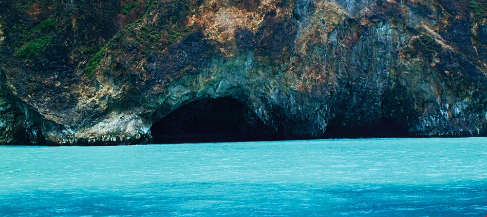
The volcanic cliffs on the southern side of Guishan Island have been eroded by the sea, forming caves that look like eyeglasses. The caves, with their stalactites and stalagmites, are one of the island’s “eight wonders.”
Taiwan, located at the boundary between the Eurasian and Philippine tectonic plates, was produced by these two plates pressing together and lifting up the sea floor. As the plates continued to press against each other, the heavier marine plate started being subducted beneath the continental plate, part of it being melted into magma by the high temperatures of the earth’s interior.
Volcanic eruptions are caused by intense magmatic activity surging upward and rupturing the earth’s crust. The spewing lava cools, and the resulting mounds form arcs of volcanic islands, such as the Ryukyu island chain that stretches southwestward from Japan. This chain of islands is called the Ryukyu Arc. The volcanic belt of northern Taiwan, which includes Guishan Island, is composed of volcanoes at the western end of the Ryukyu Arc.
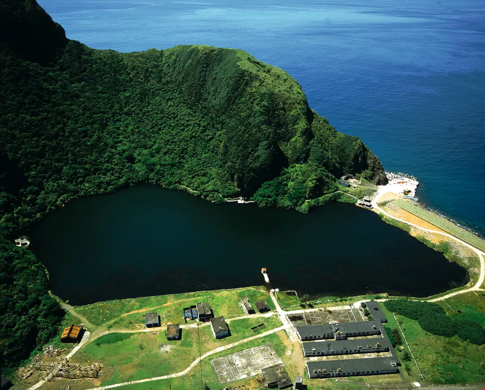
Walking the trail that encircles Guiwei Lake is a must-do for those visiting Guishan Island.
An alternative idea is that Guishan Island may be a volcano created by seafloor activity in the Okinawa Trough.
The Okinawa Trough is a seafloor basin formed by the rifting of the Ryukyu Arc on the eastern fringe of the Asian continent. Guishan Island happens to be located at the meeting point of the Okinawa Trough and the Ryukyu Arc.
A survey conducted by a joint Taiwanese/French research team found that there are at least 60 to 70 active seafloor volcanoes on the seabed of the Okinawa Trough to the east of Guishan Island. Guishan Island is the only volcano within this region that rises above the ocean’s surface.
However, was Guishan Island’s formation also like that of the submarine volcanoes surrounding it, starting with the eruption of undersea magma?
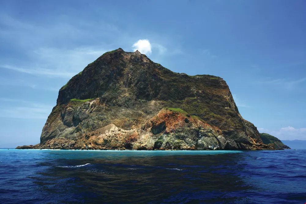
Besides visiting the island, taking a boat ride around the island to view its volcanic appearance and watch whales and dolphins is a popular activity on a Guishan Island tour.
Song Sheng-rong, professor of geosciences at National Taiwan University, says that by analyzing the products of Guishan Island’s volcanism, we can deduce that the island was not formed by submarine eruptions.
In a submarine volcanic eruption, the magma comes quickly into contact with seawater, forming glassy, unstably structured rocks or lava flows. But in a “subaerial” eruption—an eruption that is exposed to the atmosphere—when magma cools it undergoes thermal oxidation with the air, turning the ferrous (Fe2+) component of the rock into ferric (Fe3+), and thereby changing the color of the rock from charcoal grey to brownish red.
The volcanic rock on Guishan Island mainly comprises accumulated pyroclastic rock and lava flows. Song states that most lava flows appear brownish red, and the rocks are mostly not glassy, indicating that the eruptions occurred chiefly on the land. In this way we can deduce that sea levels have risen since the time of the eruptions that formed Guishan Island.
The silicon dioxide content of the magma determines the properties of volcanic rock. With the notable exception of Penghu basalt, most volcanoes in Taiwan, including Guishan Island, are andesitic in nature.
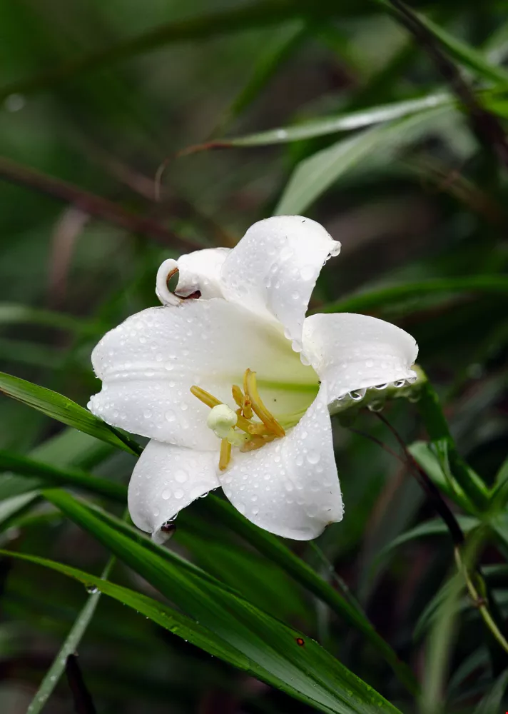
The tail of Guishan Island is suitable for tourism. If you go in the springtime, you may see blooming Formosa lilies.
There are two volcanic vents on Guishan Island: one at the head of the turtle and one at the shell. A survey by an NTU Geosciences Department research team suggests that the volcano at the turtle’s shell has erupted at least four times in the past 7,000 years, but the most recent eruption may have occurred at the turtle’s head.
The turtle’s shell is the main section of Guishan Island, with the highest point being 401 Peak at the middle of the southern end of the shell. The volcanic vent may be located there.
The turtle’s head, located on the eastern end of Guishan Island, is shaped like an elliptic cone. Its topography is high in the east and low in the west, and its coastline is steep. The volcano at the turtle’s head is believed to be younger than the volcano on the turtle’s shell. Fumaroles have been found on the sea floor by the turtle’s head, spewing hot sulfurous gases and forming marine hot springs. The gases bubbling to the surface appear as a roiling white foam that can be seen year round. This seabed hot spring is one of Guishan Island’s “eight wonders.”
There are also fumaroles on the cliff, constantly emitting sulfurous fumes, another of the “eight wonders.”
Volcanic rock is a remnant of eruptions. In addition to andesitic volcanic debris, heaps of volcanic ash of different grain sizes can be seen in the area from the turtle’s head to its neck.
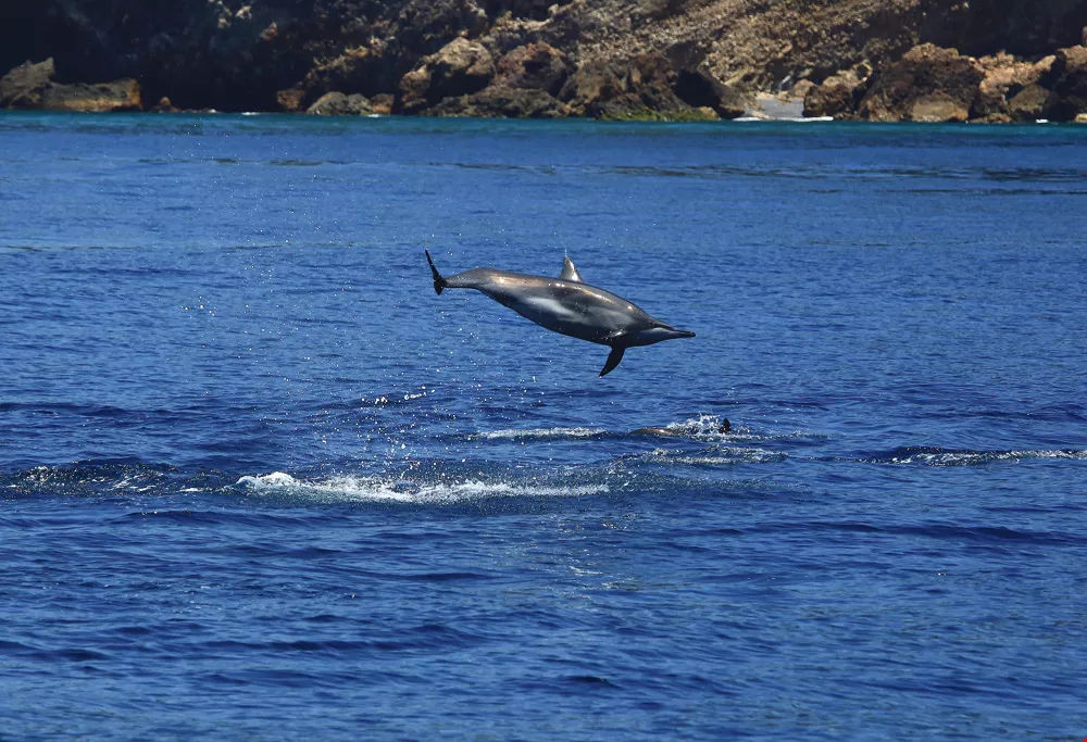
Besides visiting the island, taking a boat ride around the island to view its volcanic appearance and watch whales and dolphins is a popular activity on a Guishan Island tour.
In 2000, Guishan Island was officially incorporated within the Tourism Bureau’s Northeast Coast National Scenic Area, and it was opened to a limited number of tourists a day. But somewhat disappointingly, the level areas most suited to recreation are clustered at the turtle’s tail, which takes up just one tenth of the island’s area.
Liu Shih-ming, deputy director of the Northeast and Yilan Coast National Scenic Area Administration, says that people walking on the loop trail around Guiwei Lake, located at the turtle’s tail, can see artillery emplacements and tunnels left behind after the military base was closed, as well as houses and historical objects of island residents from an earlier time. In addition, coastal vegetation such as butterfruit and screwpine grows here in abundance, and in the springtime you can see lilies blooming. It takes about an hour and a half to explore the turtle’s tail.
The turtle’s tail itself is a spur of gravel beach that juts about a kilometer into the sea. It moves north and south with seasonal winds and currents, creating the legendary “wagging turtle tail.” The closer you get to the turtle shell, the more clearly you can see the volcanic vistas of lava hills and volcanic rocks.
According to the scenic area administration, there have been around 110,000 visits to the island per year in the last three years. To see the more inaccessible turtle head and shell, you need to take a boat trip around the island.
Monitoring for eruptionsThough Guishan Island meets the definition of an active volcano (i.e., having had an eruption within the last 10,000 years), some believe that judging from the weakness of the fumarole jets on the cliff face, the chances that Guishan Island will erupt again are next to nothing.
Song Sheng-rong holds a less optimistic view on this issue. He mentions that there was a major landslide at the turtle’s head several years ago. The reason why the gas emissions have not been as strong as in previous recorded data may be that the sulfurous fumaroles fell into the sea during the landslide, but this doesn’t prove that subterranean magmatic activity has stagnated. It’s necessary to keep monitoring, and we cannot let our guard down.
If Guishan Island’s volcano were to erupt, the resulting lava flows and volcanic debris would certainly endanger human life. Fortunately, only Coast Guard personnel are stationed on the island at this time, and the number of people visiting the island is limited to 1,000 a day, so monitoring and early warning should allow for early evacuation, thereby minimizing casualties.
Song Sheng-rong says that there will be clear signs of changing magmatic activity before a volcanic eruption, making it easier to predict eruptions than earthquakes. For example, the actual date of the 1991 eruption of Mt. Pinatubo in the Philippines differed by one day from the predicted date.
Also, tsunamis and volcanic ash fallout triggered by volcanic eruptions can deal a significant blow to surrounding areas.
Song cautions that given the activity of the seabed hot springs at the turtle’s head, magmatic activity is still growing. “It is indeed an active volcano, and there is a very real possibility of eruption in the future.” But there’s no need to be overly worried, because the more we keep watch, the safer we well be.

@List.jpg?w=522&h=410&mode=crop&format=webp&quality=80)

@List.jpg?w=522&h=410&mode=crop&format=webp&quality=80)


