Covering All the Bases... and the Peaks: On the Trail of Lin Tsung-sheng
Jenny Hu / photos Lin Meng-san / tr. by Phil Newell
February 1995

He is not a botanist, nor is he a geologist. He is not an entomologist, an ichthyologist, an ornithologist, or a zoologist. Nor is he an anthropologist. Yet he wants to complete a huge project that covers all fields--to write a biography of the mountains.
Some people doubt that he has the right stuff. But for him, this is a mission, for his own mountain climbing career and for the passing of the torch to the next generation of climbers.
Twenty-seven years ago, a young know-nothing rode his bike to the bank of the Tanshui River, and climbed to the top of Kuanyin Mountain.
This was his first mountain. His interest had been piqued by Outdoor magazine's reports on mountaineering. And now, for the first time, there he was looking out across the distance from the vantage point of a mountain peak, exploring the undulating mountains and rivers with his own eyes.
The vast sky opened out before him, while light flashed off the water at the mouth of the Tanshui River. But what thrilled him most was the vista of mountains climbing up into the clouds at the edge of the Kuantu Plain on the other side of the river. "That's Tatun Mountain," said someone next to him.
The Tatun Mountain group comprises the back slope of Yangmingshan National Park, sloping down toward Tanshui. In the Japanese occupation era, "springtime on Tatun Mountain" was one of the eight scenic wonders of Taiwan. When the time was right, almost everybody in Taipei would climb up Yangming Mountain to admire the flowers and go to Peitou to soak in the hot springs. It was even whispered that there was a pathway up to the peak of Tatun and Chihsing mountains, and that there were smoking sulphur gorges hidden amidst the bluffs.
This is Taiwan's only volcanic mountain chain. In those days there was no national park, nor was mountaineering very popular. Most visitors stuck to the area around what is now the Yangmingshan National Park. For those who wanted to climb Tatun, there was but a narrow stone pathway, and you needed a guide to find even that. Underneath dense forest cover were hidden the more than 60 different peaks of the Tatun Mountain group. As far as the people of Taipei were concerned, 90% of the area was either a complete unknown or the source of mysterious legends.
As this youth from Wanhua gazed out across the clouds into the unfathomably deep and soaring precipices, he longingly made a vow: "Someday, I will climb across the entire Tatun mountain group, and wade through every stream."
He was sixteen.
At the volcano crater on Little Kuanyin Mountain, Lin Tsung-sheng is testing an "anti-direction rock." This is a rock spit up by a volcano, which, because of its mineral content, affects the magnetic field and distorts compass directions.
Like a madman
Today, nearly 30 years later, when you mention Lin Tsung-sheng, even Lu Li-chang, the head of the Office of Guides at the Yangmingshan National Park Headquarters, has to admit: "He's probably more familiar with the Tatun Mountain group than anyone."
The scene: A rickety old dwelling of 20 ping built on the roof of a building in Taipei's Wanhua district. Half of the walls have been converted into an artificial rock face for practicing climbing. The other half is piled high with two or three thousand books in Japanese, Chinese, and English on mountain climbing and nature. There is a bathroom, but it is packed full of mountain climbing and survival gear.
This tiny structure, without even enough room for a guest to sit down, is Lin's research room for his studies of the natural environment in the mountains. He is sitting, squeezed into a small space among the books, looking at slides and writing. From time to time he reaches into the ocean of texts to accurately retrieve a reference book, which he opens to the chapter and page he is looking for. "I hope I can finish my Encyclopedic Survey of the Tatun Volcanic Mountains before the year 2000, but that doesn't seem very likely," he says with a sardonic laugh.
After his revelation on Kuanyin Mountain at age 16, he became mad for the mountains. But he wasn't just interested in carving paths to the top. In fact, the rich variety of life in the mountain forests and the artifacts left behind by other peoples attracted him even more. "I often asked myself what a mountain climber should do besides just get to the top," he explains. From the stars above to the earth beneath his feet, to the ever present flora and fauna, rivers and peaks, there was nothing that he did not crave to understand and explore. He set his sights on Taiwan, yet was unable to discover one book devoted to recording the natural environment in Taiwan. "Since no one else would do it, I decided to do it myself."
That is how the Tatun volcanic mountain group became his touchstone. To his way of thinking, these old mountains were closest to him both spacially and emotionally, and he decided to record the geologic shifts, distribution of vegetation, and human activities that took place there. "The mountains are alive, and they have their own artifacts." He is writing the record to pass along his knowledge of the hills, providing a comprehensive reference source to all wishing to go into the mountains and get close to nature.
He has never received any financial support, and estimates that he has spent NT$5 million, with thousands of trips into the mountains. Don't even ask about the investment in transportation and effort. His occupation is as an employee at the Ninth Credit Cooperative in Taipei. "Like a madman," is how he describes himself.
This first-ever survey of the natural environment done through mountaineering covers the whole Tatun mountain area, geologically defined. Besides the Tatun mountain group, which alone has an area larger than Yangmingshan National Park (and which includes the Chutzu mountain chain, the Chihsing-Huangtsui mountain chain, and the Tingshan mountain chain), the area also stretches to Kuanyin Mountain in the west, Neihu's Wuchih Mountain to the south, and the coastal watershed to the northeast. That means his area of research covers 30,000 hectares. His study has ten major parts, covering historical artifacts, river valleys, geography and geology, plant life, animal life, astronomical phenomena, landscaping and architecture, self-guided tour instructions, and mountain safety and rescue information. There are also pictures with detailed captions. All told there will be 60 to 80 volumes. Whether you are talking about the content or the thickness, either way this is an "enormous undertaking."
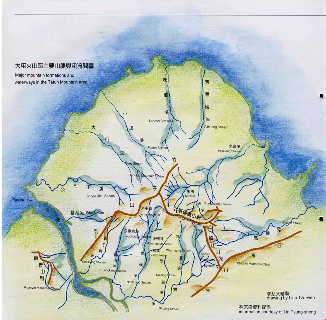
Major mountain formations and waterways in the Tatun Mountain area drawing by Liao Tzu-wen information courtesy of Lin Tsung-sheng.
A new paradise
What makes Lin, who never took a class in subjects like zoology, botany, or geology, think that he can handle such an imposing project? "I have read thousands of books, and hiked thousands of kilometers--those are my credentials," says Lin, his eyes sparkling behind black-framed glasses.
In the past decade or so, Lin Tsung-sheng has been to a primeval mountain forest that even the Yangmingshan National Park Headquarters has yet to check out. He has followed upstream more than 140 major and tributary waterways in the Tatun mountain area and discovered that "the national park that gets five million visitors a year is really just the surface." Tatun has many startling secrets hidden under its dense bamboo tree cover.
"Did you know there are two or three hundred waterfalls up here?" he asks in a tone of delight at amazing his listener. As part of his surveys of the riverine ecology, he climbed through many gorges, discovering waterfalls constantly. In particular, beneath one crashing 18-meter-high waterfall near the Malien Stream, he felt indescribably moved and inspired. Once while walking along one the 12 main tributaries of the Malien Stream he found a forest of apricot trees in full bloom along 100 meters of the stream bank. The pink, dark red, and delicate white blossoms filled the air and danced in the breeze. "Just paradise, plain and simple."
He also has explored more than 40 half-hidden caves, and thus discovered more than 10 bat caves, something long thought nearly extinct in the Tatun area. In one case, there were more than 1000 Formosan lesser horseshoe bats living in a water cave in the Huangtsui Mountain area. In the Matsao area, he came across what is most likely the largest colony of Formosan rock monkeys in northern Taiwan. There were 30-40 of the critters playing in the rocks and broad-leafed trees.
In a narrow gorge with a particularly high and fast-moving waterfall, he was startled to stumble across more than one hundred rare Dysosma pleiantha and Anoetochilus formosanus plants. As he scaled the perilous rock wall behind the waterfall, he was especially careful not to step on any of the flowers. "I was excited, but pretty nervous, too." Then there is the Monachosorum henryi, thought to grow only at altitudes over 1000 meters and previously only seen in the Tatun Mountain area by the naturalist Li Juei-tsung. Lin found some on Huangtsui Mountain, proving that they are distributed down as far as 700 meters above sea level. "It was really an unexpected delight."
Previously people had thought the number of old trails up Tatun Mountain limited to the Yulu, Tienmu, and Mientien trails. But Lin Tsung-sheng discovered several old paths, including the old Sulphur Trail used to bring sulphur down from the mountains; the Tatun River Trail, which follows the Tatun River upstream and runs past the largest volcanic crater in Taiwan (on Little Kuanyin Mountain); the Jungjun Trail, which forty years ago was clearly marked but today has been completely overgrown and obscured; the Luchuehping, Palien, Wanhsi, and Fushih trails; and the Chutzu Mountain Trail, which has an 820 meter drop in elevation.
The trails have led to discoveries of old stone dwellings. In the past it was thought that were only one or two such structures, located along the Fushih Trail. But last year, when Lin took his "Old Trail Club" on a hike, as they were clearing away underbrush they uncovered a number of dwellings as well as tools and implements. This was a major anthropological find for the national park.
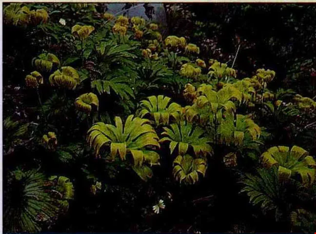
Dipteris conjugata along the Sulphur Trail. (photo courtesy of Lin Tsung-sheng)
Tatun storm
Lin Tsung-sheng is a "renaissance man" for a mountaineering fanatic. Twenty years ago he led the way in bringing "orienteering" (a type of tracking or direction-finding technique) to Taiwan from Japan. He was the assistant director of the "Bear Team" of the Taipei City Mountaineering Association. He was a mountain guide for the police. He worked as a guidance counselor for ten years for the Outdoors Club at Shih Chien College promoting diversification of mountain climbing activities. In the last post, he took his students on all sorts of outdoor activities, and nearby Tatun mountain served most frequently as their ecological classroom.
In 1979, he took students up to survey the flora and fauna of the Tatun area, beginning a series of explorations. In 1980 he began to collect butterflies from Mientien Mountain. In 1982 he offered classes in orienteering techniques. In 1983 he began a survey of the temples and night ecology on Tatun Mountain, and in 1985 began a survey of the seasonal variations of flowers.
He read voraciously, took his students to see what he had read about, and invited zoologists, botanists, geologists, and other scholars to give lectures. "The deeper I got into Tatun Mountain, the less I felt able to stop." Studies commissioned by the national park have always focused on some narrow specialization, and progress in opening up new areas is slow. They could no longer satisfy his desire to know everything there is to know about the area.
In 1984, he first came into contact with Japanese "stream tracing" techniques (for following rivers and streams to their sources). This was the key which unlocked for him the doorway to all his later surveys of areas deep in the mountains.
In 1988, Lin drew up a plan for himself, which he called "Tatun Storm." He began stream tracing in the area, opened paths, and began doing a survey of trails. In that year, he climbed across the entire Chingtienkang mountain series, and followed a river all the way up Chutzu Mountain (which is to this day a restricted military area). He completed his explorations of the whole Kuanyin Mountain area in 1989, and spent all of 1990 in the Huangtsui Mountain ecological conservation area.
"That was a very lonely journey," he says. Because stream tracing is best done in a team, in the past he always invited mountaineering friends to join him. But most of these were amateurs, just along for fun, and would always beg off the climb if they had some personal matter to attend to. Thus Lin often faced the problem of being all set to climb bright and early in the morning but being unable to find any partners.
His ideals of making a record of nature and of "turning mountain climbing into a study of all natural things" are deeply entrenched. Unsure of when this ambitious project might be finished if he tried to go it alone, Lin decided to organize some like-minded followers to help. In 1990 he formally established the Alpine Research Institute. He trained students in stream tracing, orienteering, and outdoor survival. In the last four years he has established a number of clubs specializing in stream tracing, old trails, spelunking, old trees, and orienteering, plus the Taiwan Hundred Mountains Club. He has trained nearly 400 students, who have become extensions of himself.
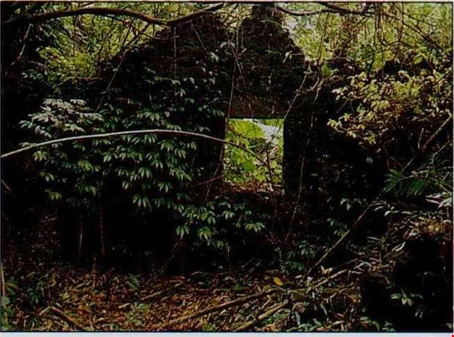
A stone dwelling discovered on the Fushih Trail. (photo courtesy of Lin Tsung-sheng)
Almost a total disaster
Constant discoveries and surprises have drawn Lin in ever more deeply. But the mountains also pose many threats to the researcher.
He has been bitten by snakes, stung by vespids, and fallen off rock faces. He once nearly drowned after getting caught in a whirlpool while crossing some water. Another time, while doing a survey, as the team was circling a 30-meter-high cliff the lead man accidentally started rocks sliding down onto a hornets' nest: "Within minutes there were tens of thousands of hornets in the air, concentrated in the broad-leafed forest area, and turning the sunny sky into dusk. The sound of the swarm reverberated like a bomber plane." Looking back, he still feels a chill. If they hadn't had the trees to duck under, "probably the whole survey team would have been lost."
Much of the area Lin surveys is part of the protected conservation area in the national park, or is under military jurisdiction. Though he conceals precise locations when he releases reports publicly, nevertheless, many people see reports in the mass media and call the Yangminshan National Park Headquarters with inquiries. This has brought Lin some complaining phone calls from the Park.
"The natural environment is a resource that belongs to everyone, and the people have the right to understand the environment around them," is how Lin thinks about his promotion of the study of nature. But in order to insure that these resources are not overexploited, polluted, or destroyed by being made public, Lin's bottom line in his Encyclopedic Survey is "absolutely never reveal the specific location." Still, when you think about it, he says, "these places are hidden behind deep pools, narrow cliffs, and waterfalls, and there are vespids, poisonous snakes, and leeches all around, so--judging from the way most people in Taiwan live--there wouldn't be very many people with the interest and the endurance to go."
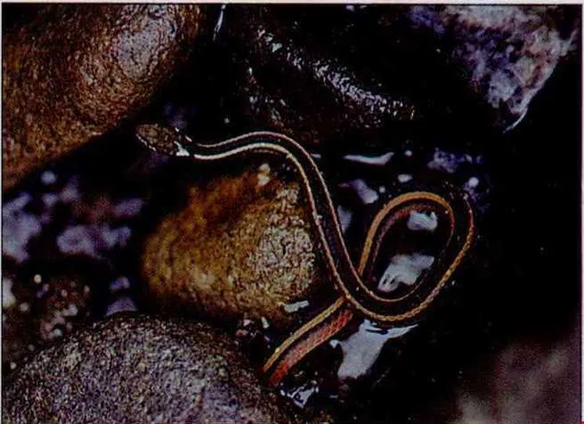
A rare snake of Taiwan: the Natrix miyajimae. (photo courtesy of Lin Tsung-sheng)
No more mountain accidents
In his transition from "mountain climber" to "mountain climbing naturalist," Lin does not hesitate to say, he has depended heavily on the voluminous historical records of the experiences and knowledge left behind by Japanese alpinists.
In order to be able to read the great number of works on mountaineering in Japanese, he began studying the language in high school. While studying in Tamkang University, after his daytime business administration classes were over he would sit in on Japanese classes in the evening.
"The Japanese lead the world in mountaineering exploits, and in writings as well. Just take any little spider you might see along the trail, and they've got a book where you can look up a picture of it." In comparison, Taiwan--three-fourths of which is covered in mountains and which reputedly has four million people who enjoy hiking--"is extremely lacking in the spirit of research, and has produced nothing of the same quality."
The lack of knowledge among Taiwanese climbers leads to frequent alpine accidents. Even though nature and artifacts are the focus of Lin's work, he made "Rescues in Mountain Emergencies" a major segment of his survey. The reason is his "love-hate relationship" with Huangtsui Mountain.
"Before the national park was established, Huangtsui Mountain was an Eden for alpinists," is how Lin describes it. It has temperate zone grasses, beautiful and imposing precipices, an elegant volcanic crater lake, and the delightful Tsui Tsui Valley. But after it was placed within the conservation area of the park, the trails became overgrown. With the treacherous weather brought by the northeast winds six months a year added in, many cases of people losing their way are reported. In 1975 three National Taiwan University students froze to death here after getting lost. In 1990, Lin and his team were about to turn back one winter day when the weather suddenly changed for the worse in less than an afternoon; one team member insisted on going on to the top, and they ended up rescuing a freezing student who was lost.
With this lesson in mind, Lin undertook a rescue training exercise and--for the first time for any author--made rescue techniques an important part of his work. This could be seen as one mountaineering fanatic lending support to like-minded people.
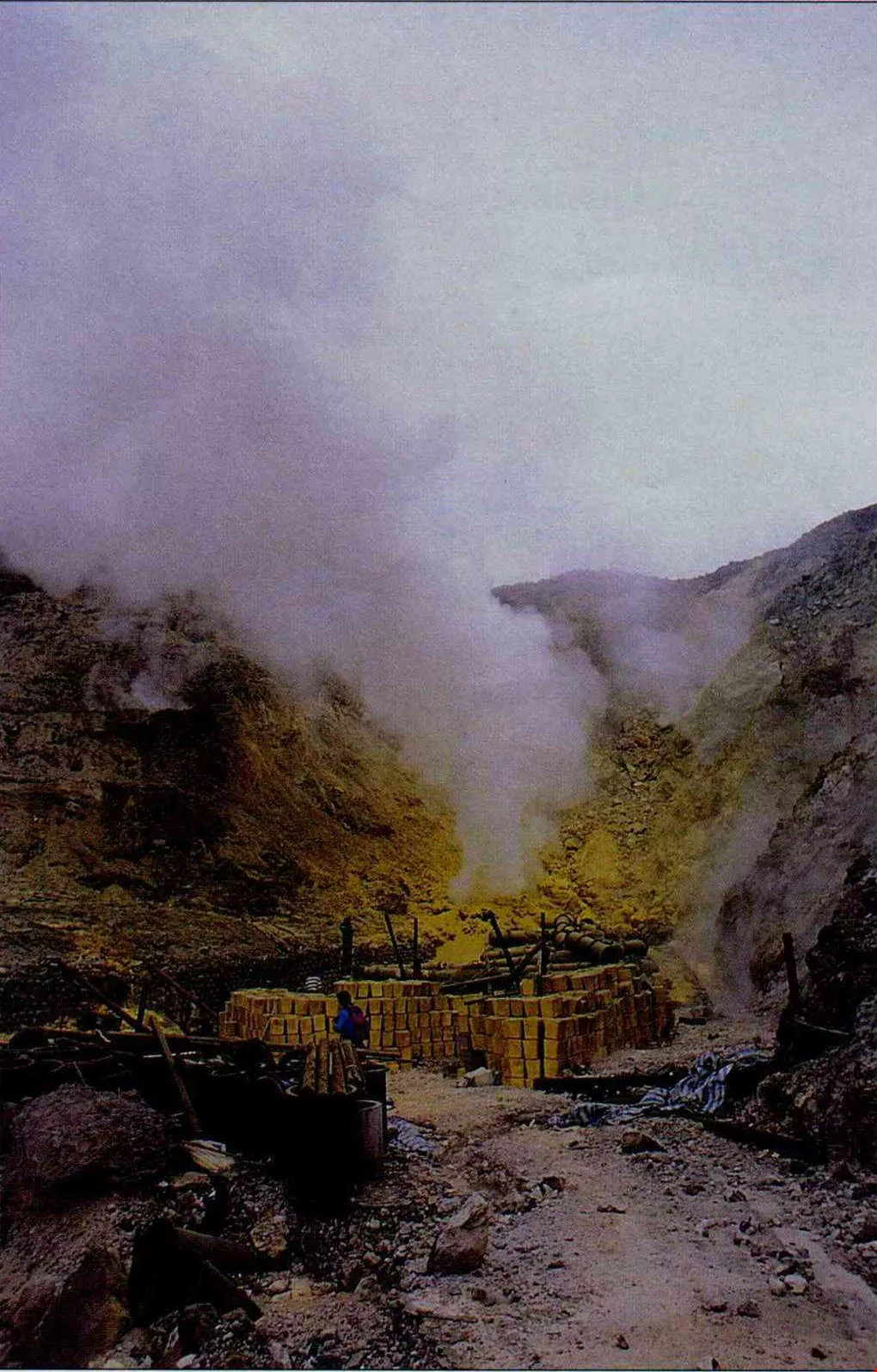
Tayoukang is Taiwan's most impressive sulphur gorge. It used to be a flourishing area for the extraction of sulphur; now it has been virtually abandoned.
I have six dreams
Today, the nature encyclopedia he is determined to write himself is tens of times thicker than the volume A Record of the Mountain Environments of Japan. In the Japanese occupation era some Japanese produced A Record of Plant Life on Tatun Mountain. Now, all of the segments in Lin's A Record of the Tatun Volcanic Mountain--on rivers, waterfall, snakes, tracking, hot springs, sulphur, shrubbery.... are appearing one by one in Mountaineering Magazine.
For half of every year Tatun Mountain is swept by winds from the northeast, and rain and fog delay the work of surveying and photographing. And, regardless of the season, finding money and qualified assistants is always problematic. Lin's Encyclopedic Survey of the Tatun Volcanic Mountains still has a long road before it.
But Lin has already mapped out five dreams that will follow completion of his work: completing a history of mountaineering in Taiwan, a Taiwan edition of the World Mountaineering Encyclopedia, a book introducing famous mountains in Taiwan, an encyclopedic survey of the natural surroundings in the mountains around Keelung, and a similar work for Taiwan's highest peaks. He figures he could be finished in 2020, "or perhaps never." He has already prepared himself psychologically for the journey to old age.
Looking back, Lin has been in dire financial straits several times, and worked so hard that he brought on hepatitis. But promoting the comprehensive survey of the natural surroundings of Taiwan's mountains has become his life's work. "At first I had no great ambitions, but now I know I can't look back." His greatest wish is to equal, or even surpass, the best work of the Japanese.
[Picture Caption]
p.38
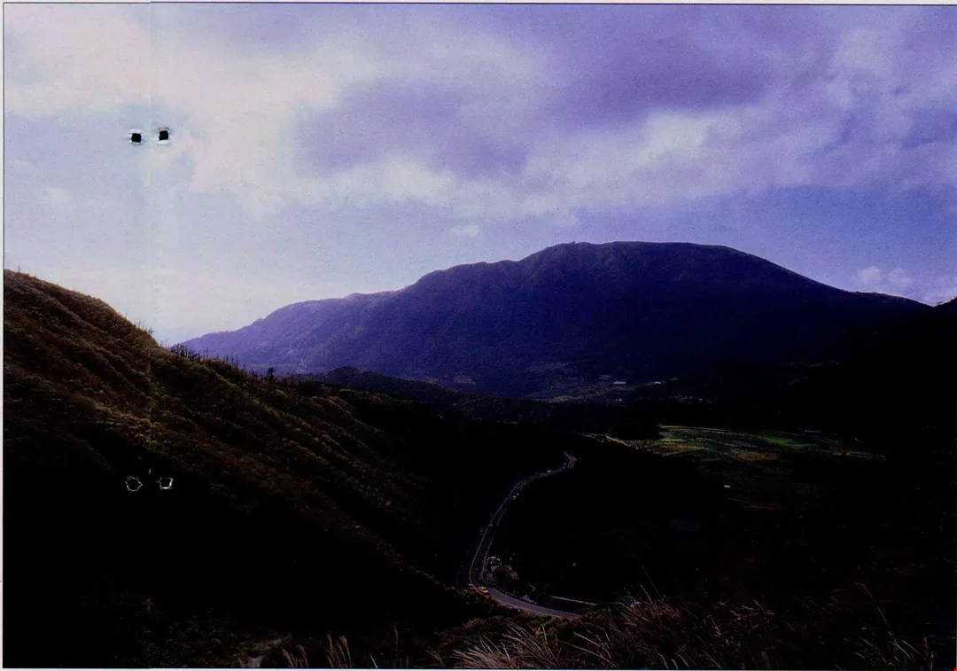
Amidst grasses, dwarf bamboo, and broad leafed trees, how many valuable ecological resources are hidden in the Tatun volcanic mountain area of 30,000 hectares?
p.38
At the volcano crater on Little Kuanyin Mountain, Lin Tsung-sheng is testing an "anti-direction rock." This is a rock spit up by a volcano, which, because of its mineral content, affects the magnetic field and distorts compass directions.
p.40
Major mountain formations and waterways in the Tatun Mountain area
p.40
Dipteris conjugata along the Sulphur Trail. (photo courtesy of Lin Tsung-sheng)
p.40
A stone dwelling discovered on the Fushih Trail. (photo courtesy of Lin Tsung-sheng)
p.40
A rare snake of Taiwan: the Natrix miyajimae. (photo courtesy of Lin Tsung-sheng)
drawing by Liao Tzu-wen
information courtesy of Lin Tsung-sheng
p.41
Tayoukang is Taiwan's most impressive sulphur gorge. It used to be a flourishing area for the extraction of sulphur; now it has been virtually abandoned.
p.42
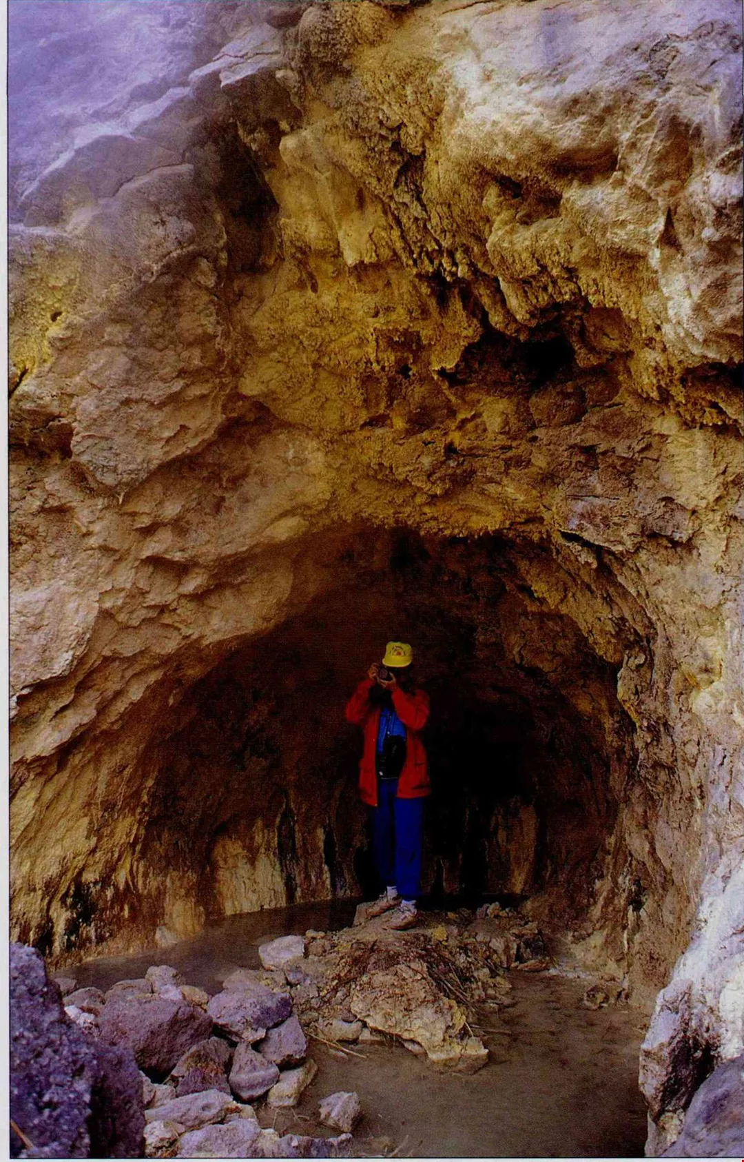
Enter a stone cave and find the residence of Formosan lesser horseshoe bats.
p.43
Caves along a stream-tracing route are also fascinating to Lin Tsung-sheng.
p.44
Lin trekked alone to the largest waterfall in the Tatun area--the Laomei Waterfall. In order to exhaustively survey the natural ecology of the Tatun Mountain area, Lin has explored every nook and cranny. (courtesy of Lin Tsung-sheng)
p.46
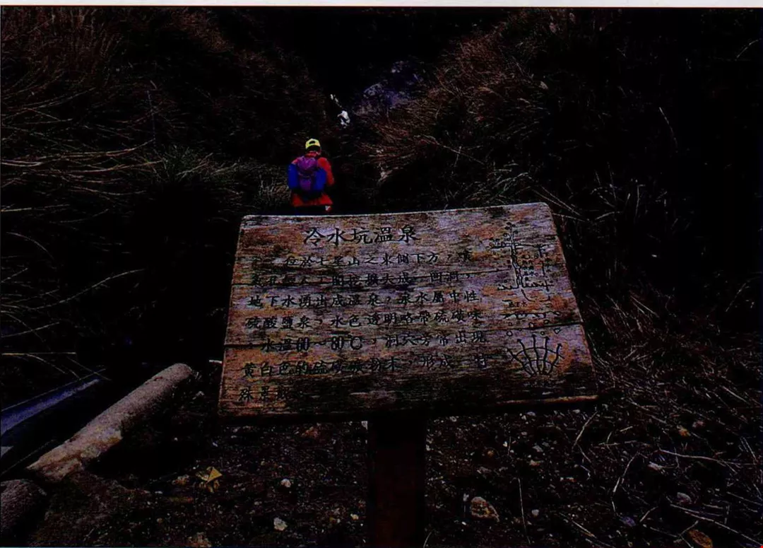
Lin has visited hot springs throughout the mountains.
P.47
Lin is firmly set on promoting the comprehensive study of nature in the mountains.
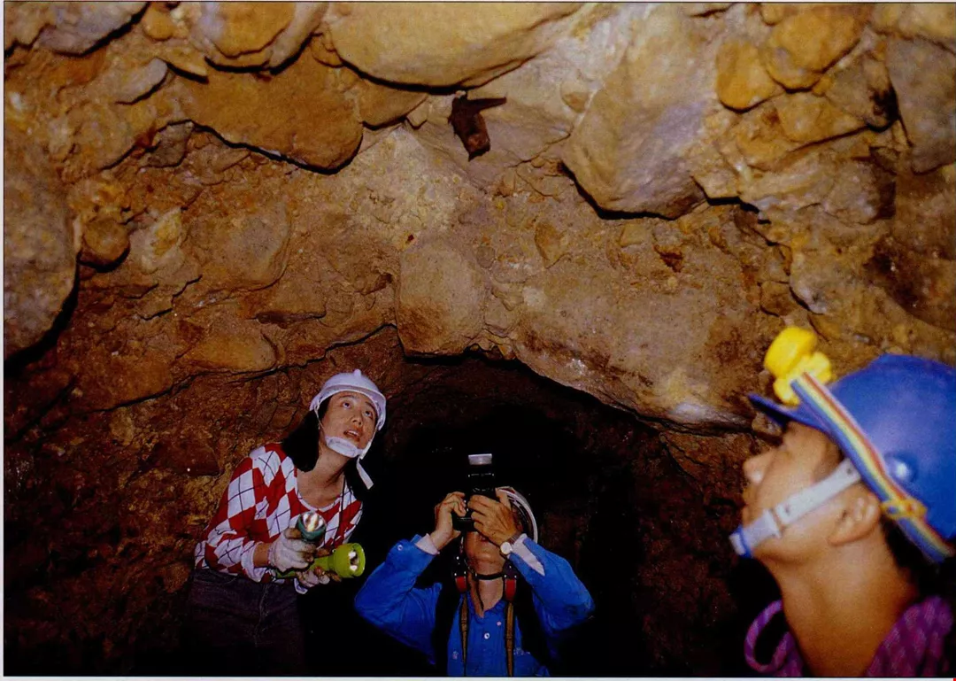
Enter a stone cave and find the residence of Formosan lesser horseshoe bats.
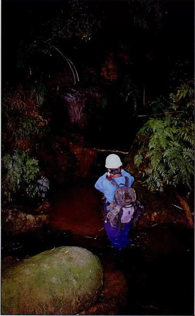
Caves along a stream-tracing route are also fascinating to Lin Tsung-sheng.
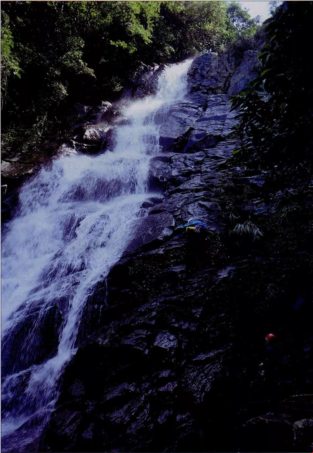
Lin trekked alone to the largest waterfall in the Tatun area--the Laomei Waterfall. In order to exhaustively survey the natural ecology of the Tatun Mountain area, Lin has explored every nook and cranny. (courtesy of Lin Tsung-sheng)
Lin has visited hot springs throughout the mountains.
Lin is firmly set on promoting the comprehensive study of nature in the mountains.


