
During the 1930s, Japanese natu-ralist Kano Tadao, who had traveled extensively throughout Taiwan, said, "The Yushan area has the mountains and inhabitants with the most native Taiwanese character." Well-known contemporary Taiwanese naturalist author Liu Ko-hsiang has expressed his belief that Yushan (Jade Mountain) is the best destination for viewing Taiwan's alpine ecology.
There are more than 200 mountains over 3000 meters tall in Taiwan. So what natural characteristics does Yushan possess to enable it stand as a representative of Taiwan's mountain ecology?
With the opening of the New Cross-Island Highway 13 years ago, as well as the renovation and expansion of hiking trails within Taiwan's national parks, Yushan-Taiwan's highest mountain-became relatively more accessible to the general public compared with others of Taiwan's "100 great peaks." Today, now that ecotourism is encouraged, let us join an eco-tour organized by Yushan National Park. Accompanied by the same sights that have greeted so many Yushan visitors, past and present, let us together explore Yushan's bountiful ecological riches.
"Look over there. A magnificent and auspicious blue view has appeared in the heavens. Thus embellished, that row of bare precipices from Yushan's main summit to its eastern peak at that moment is like a rainbow, reflecting a dazzling auburn light. The creases on the mountain walls gently project a restrained cobalt blue." So does Kano Tadao describe, in his naturalist classic Mountains, Clouds and Barbarians, the powerful impressions made on the senses by Yushan's splendid and unusual sights.
No doubt many of those who have reached Yushan's summit can empathize with Kano Tadao's indescribable awe at the majestic scene. Standing on the mountain's peak, one sees extending in every direction the peaks surrounding Yushan, one after another piercing a sea of clouds. Seeming to go on forever, how could the scene not inspire awe?
Besides the exclamations, most team leaders or volunteer guides will explain the terrain to those who have reached the peak for the first time. Yushan's main peak is first surrounded as if by satellites by the eastern peak (the mightiest of Taiwan's ten loftiest summits), the southern peak, and the western peak. Then, moving outwards, one can spot the main ridge of the Central Mountain Range (Mt. Mapolassu and Mt. Hsiukuluan) to the east, while to the south lies Mt. Hsinkang, also one of the ten loftiest summits, and southern Taiwan's tallest, Mt. Kuan. To the west is the Mt. Ali Range, while to the north one can spot Mt. Tungchun and even Mt. Hsueh in the distance. Taiwan's most renowned mountains are all in one's purview. Yushan is situated in the center of the island, and is called "Taiwan's rooftop." Its towering presence is beyond the power of words to describe.
Additionally, the summit provides a panoramic view of the main sources of water that nourish the land. The Nantsaihsien River and Laonung River are the sources of southern Taiwan's Kaoping River; the Chenyoulan River, largest tributary of central Taiwan's Choshui River, winds its way to the northwest; and the valley of the Lakulaku River, which feeds eastern Taiwan's Hsiukuluan River, is also visible in the distance.

In Yushan's alpine tundra zone at altitudes above 3500 meters, the soil is parched and covered by gravel, and strong winds and heavy snowfall make plant growth slow. The photograph shows the forbidding terrain in the area below Yushan's main peak.
Rugged beauty
"The upstream parts of the main river valleys in the national park are V-shaped," says Chen Lung-sheng, deputy director of the Yushan National Park Administration. Yushan is the ideal classroom for observing and getting to know Taiwan's landscape and rivers.
For example, the Chenyoulan River that originates in Yushan's northern foothills formed along a geological fault line. Its course runs down a steep incline, paralleling the Japanese-built branch of the Patungkuan Trail from Tungpu to Tuikuan. Along the trail, one can see landscape features such as the V-shaped river valley and waterfalls, cliffs, and areas of geological collapse. Of these features, Chinmentung Cliffs is among the most distinctive. Taiwan's largest area of geological collapse, it was formed by intense headward erosion produced by the Chenyoulan River. At the headwaters, it was formed as the result of massive landslides.
At the same time, because the speed of the headward erosion due to the Chenyoulan River on the north slope of the cliffs is much greater than that caused by the Laonung River on the southern slope, a "river capture" process is taking place. "At present, the Chenyoulan is gradually encroaching on the Laonung River. It's just that the capture process is not yet complete," notes Chen Lung-sheng. Once the capture is complete, the headwaters of the Laonung River will flow into the Chenyoulan River.
Chen even predicts, based on the Chinmentung Cliffs' rate of collapse and evolving trends, that the area of collapse will continue to expand. Within 15 to 20 years, headward erosion effects may reach the main peak of Yushan and the eastern slope of the north peak, causing a major change in the topology and appearance of the area from Yushan to the Patungkuan area.
Besides the diverse terrain, the most notable feature provided by an Yushan eco-tour is the rich variety of forests, including frigid, temperate and subtropical types. Compared to birds and other animals, whose visibility is influenced by factors such as time of day, season, and the presence of people, towering old trees are silent and steady company. People need only be willing to get close, and they will respond warmly.
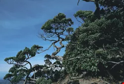
Yushan's Chinese juniper trees have developed twisted trunks, giving them the appearance of bonsai when seen from a distance.
Taiwan's arctic zone
"In the wind, we pass through a bamboo grove and prairie. / In the wind we pass through the firs. / Only the broken ridges and worn mountains poke through the mist / to greet us. / Accompanying us are Chinese juniper and azalea, / blossoming on the bare rock near where we have trod. / The sunlight slips in between the slender green forest leaves."
What the poet Xiang Yang describes in this poem "Mountain Road" is the sights as one descends along gravelly slopes from the peak of Yushan at an altitude of 3952 meters above sea level, passing the tundra zone, and then on to the fir forest belt. The alpine tundra of Yushan above 3500 meters offers views and vegetation extremely similar to arctic tundra. As temperatures are low throughout the year and strong alpine winds prevail, while the ground is covered by gravel, conditions for survival are extremely harsh. Therefore, the plants that grow here either set their roots down between seams in the rock, or grow close to the ground. Trees such as Chinese juniper and Yushan azalea have evolved twisted trunks and ground-hugging creeping habits to adapt to this environment. Moreover, they grow slowly, with Chinese juniper said to take 2200 years to grow to a trunk diameter of one meter.
The herb plants all have beautiful names-Yushan edelweiss, mountain ladybell root, Yushan moss. Of these, Yushan edelweiss is closely related to the edelweiss found high in the Alps and made famous by the movie The Sound of Music. The ancestors of both originated in the Himalayas, with the Yushan edelweiss evolving into a species unique to Taiwan.
"Seventy or 80% of the organisms living at the summit of Yushan are unique to Taiwan." Chen Yueh-fong, vice president of Taiwan's Providence University and a pioneering Taiwanese conservationist, often uses Yushan as an example to explain subjects such as Taiwan's ecological habitats and species evolution. During speeches and when teaching courses, he will often encourage everyone to visit Yushan: "To truly understand Taiwan's ecology, one must go to its high mountains."
In Taiwan's mountains, at an altitude of around 3500 meters, the timberline is readily apparent. Above this boundary, trees are unable to grow to great heights, while below it, trees can become giants. When one sees the imposing mass of the Chinese juniper in Yushan's fir forest belt below the timberline, it is truly difficult to imagine that they are the same species of tree as the bonsai-like Chinese juniper just seen.
Just below the tundra zone, at altitudes of 3500 meters down to 3000 meters, is the fir forest belt, with Taiwan white fir and dwarf bamboo the major types of vegetation found. Firs have a single, straight main trunk, and moreover, only firs are found in these forests, so that they are also known as "all-fir forests." The lovely sight of the forest deeply impresses visitors. The main plant found on the floor of the fir forests is the Yushan dwarf bamboo. Because Yushan dwarf bamboo possesses well-developed underground stems, it grows in patches. It most frequently appears after fir forests have been damaged by fires, quickly sending up new shoots.
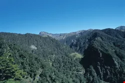
High on the mountains there is an obvious timberline, above which only herbs and low-standing shrubs are found. Below this boundary, however, fir forests thrive.
The poetry of hemlock
After descending to 3000 meters the forestation changes, as one enters the hemlock forest belt. Unlike the austere "cold" beauty of the firs, the luxuriant foliage and elegant contours of hemlock trees exude poetry, as if standing alongside the trail to enfold people in their embrace.
Growing at altitudes of 3000 meters down to 2500 meters, hemlock and spruce trees are found in cool-temperate forests. Although their main trunks are heavily forked, giving an appearance completely different from that of a fir, both are coniferous trees. The structure of a hemlock forest is similar to that of fir forests, and only a single shrub layer of Yushan dwarf bamboo is found on the forest floor. Interestingly, "In all the world, only in southwestern Chinese provinces such as Sichuan are there forests similar to Taiwan's hemlock forests in appearance, structure, and evolution," says National Taiwan University botany professor Kuo Chen-meng. In China, pandas live in this type of forest.
Having passed through the tundra, fir forest, and hemlock forest, the forest scenery from the main peak to the Tataka trailhead comes to an end. To enjoy the splendid sights of the two forest zones below, one must take the Japanese Patungkuan Trail, or the Chungchihkuan Trail in the southwest area of the park.
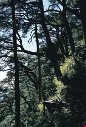
The hemlock forests found at altitudes of 2500-3000 meters are beautiful. The spirit of the forest permeates the hearts of visitors walking through, cleansing and refreshing them.
Disappearance of the cypress forests
The cypress forests growing at altitudes of 1800 to 2500 meters can be seen from the Patungkuan Trail, and are classified as warm-temperate forests. Areas at this altitude have the highest humidity in Taiwan, and are swathed in fog throughout the year.
"Taiwan's five mountain ranges form a protective shield. Atmospheric currents approaching from the Pacific are obstructed, and their moisture collects there and circulates down to medium altitudes in central Taiwan, giving rise to cloud formations such as Mt. Ali's 'sea of clouds,'" explains Chen Yueh-fong. Taiwan's tallest mountains are around 4000 meters high, so that a cloud belt forms at altitudes of around 2000 meters. Peaks such as Mt. Ali, Mt. Taiping, and Mt. Chunghsueh are of this height, and are all therefore home to cypress forests thousands of years old.
Walking on the trail through the cypress forest areas, one can no longer see complete forests, and when giant cypress trees growing on a steep slope come into view, one cannot help thinking of the series of disasters that have afflicted Taiwan's cypress forests during the last century.
At the beginning of the 20th century, Taiwan boasted a luxuriant "Great Wall" of 2000-3000-year-old cypress trees stretching from north to south spanning mountain ranges at an altitude of 2000 meters. However, after the Japanese discovered Mt. Ali's cypress forests, this situation began to change. Growing amongst the clouds, cypress trees yield wood of excellent quality with tempting economic value. As a result, the Japanese rushed to invest in logging, and overcome the difficulties associated with high-altitude logging. They built mountain railways and commenced logging operations, which later were extended to other mountain regions such as Mt. Taiping and Mt. Pahsien.
By the arrival of the Nationalist government era, policies promoting the use of agriculture and forestry to support industry led to logging areas further encroaching into mountainous areas. The decline of the cypress forests accelerated. In 1989, the government issued a ban on the logging of natural forests, but by that time, Taiwan's all-cypress forests had been all but logged out of existence. Today, only the one on Ilan County's Mt. Chilan has been fortunate enough to survive.
During the Japanese occupation and Nationalist government era, Yushan was once open for logging in the forests adjoining the Shalihsien River and Nantsaihsien River near the Mt. Ali region, as well as areas near Tataka. The tree varieties logged in greatest quantity were Taiwan red cypress, hemlock, and spruce. Perhaps because Yushan is located in the most remote part of Taiwan's mountainous regions, and access is difficult, it has largely escaped deforestation, with the exception of the cypress forests of the Nantsaihsien River, which were completely logged out, and outlying areas such as Tungpu and Tataka. The core areas in the center of the national park still boast virgin forests and a vibrant ecology.
Because cypress forests are located in the transition zone between coniferous and broadleaf forests, their structures differ greatly from pure coniferous forests composed of fir and hemlock. Coniferous and broadleaf forests in this area appear alternately, and these forests are structured in four layers. The uppermost layer is the cypress layer, with broadleaf trees, shrub layer, and herbage layer following as one moves lower. Of these, the second and third layers also include Yushan dwarf bamboo. Therefore, although cypress forests have the appearance of a coniferous forest, they possess a great diversity of species in a rich profusion of life.
Formosan bramble
Jurassic Park
If one wishes to see subtropical broadleaf forests situated at altitudes of 600 or 700 to 1800 meters above sea level, the Walami Trail in the southeastern sector of Yushan National Park provides views of a world completely different from that of the alpine and temperate zones.
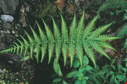
Walking along the Walami Trail, the air is warm and humid, streams and springs abundant. One is accompanied by numerous varieties of ferns, such as the large common tree-fern, tamarisk-like spikemoss, and sword ferns growing in ravaged terrain, as well as the many unnamed ferns growing along the entire mountain slope or creeping along the ground. The scene resembles nothing so much as the prehistoric environment depicted in Jurassic Park. Walami is a term from the language of the Bunun Aborigines meaning "fern," making it singularly appropriate as the name for the trail.
Along this "road of ferns" that winds alongside the Lakulaku River, the calls of rhesus monkeys emanate from somewhere far off on the mountain slopes, not seeming to much welcome these visitors who have come from afar. Catching sight of their fleeting forms in the thick forests, one is struck at how different they are from their brethren who jump onto the footpaths on Kaohsiung's Takao Hill. On the mountain paths in the early morning or at dusk, if one is lucky, one can spot the inky green, rice grain-shaped droppings of muntjac, or the hoofprints they leave along the mountainsides.
This vitality illustrates the high level of biodiversity found in broadleaf forests. With their four-level structure, along with the plants growing on branches and leaves at various levels, broadleaf forests form a varied habitat that attracts a diverse range of organisms. Additionally, due to the broad extent of the broadleaf forests, more than 40% of Taiwan's biological species can be found living in them.
Subtropical broadleaf forests consist primarily of beeches, with camphor trees being the second most common. Beeches include glaucous oak, wild walnut, and the trees that produce the sugar-roasted chestnuts often eaten in Taiwan. The seeds of beech trees are the main food for rodents, with the fruit of the glaucous oak the favorite of Formosan black bears. In recent years, international photographic teams traveling to Yushan to photograph the Formosan black bear have used the glaucous oak's fruit-bearing period in November and December, going to the Tafen area midway down the Lakulaku River, where the bears gather, to capture them on film.
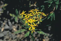
Alpine ragwort
From the arctic to the equator
Yushan National Park is crowded with peaks, and crisscrossed by river valleys, making the terrain highly varied. Additionally, vegetation zones with hot, warm, cool, and cold climates can be found at different altitudes. As a result, except for the tropical plants along the coast, virtually all the types of vegetation found in Taiwan can be observed. It is little wonder that Yushan is such a haven for botanical researchers.
The bountiful forest zones have also nurtured a riotous diversity of animals. At present, more than 150 bird species, more than 30 mammal species, 17 reptiles, and 200-plus butterfly species are known to inhabit Yushan National Park. Their numbers include species that are found only in Taiwan, such as the Formosan serow, the Formosan black bear, Swinhoe's blue pheasant, the mikado pheasant, and the Formosan salamander, a rare living fossil that has survived from the ice age.
Due to Taiwan's unique geographical position and diverse alpine terrain, as well as the numerous avenues for the immigration of new species-including transport by ocean currents, settlement by migratory birds, the mass migration of species during the ice age when Taiwan and the Chinese mainland were connected-the high level of biodiversity on the island greatly exceeds that of any other place on Earth. And Yushan best exemplifies Taiwan's unique status.
Some say that during the several days one spends walking from the foot of Yushan to its peak one can see the tropics turn into the arctic, and see the transformation of flora and fauna over a span of several thousand meters of altitude-is this not another "Taiwanese miracle"? Do you wish to get acquainted with the magic and fecundity of Taiwan's natural environment? Hike up Yushan!
The marsh-fern Glaphyropteridopsis erubescens

Wild taro
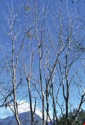
Set off against the blue sky, the subcostate crape myrtle conveys a delicate poetry. This tree is commonly found in subtropical broadleaf forests. In winter, it sheds all its leaves.
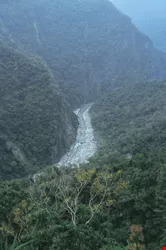
Broadleaf forest zones offer varied habitats, and the degree of biodiversity they support is the greatest of any forest zone. The photograph shows the virgin broadleaf forests along the downstream portions of the Lakulaku River.
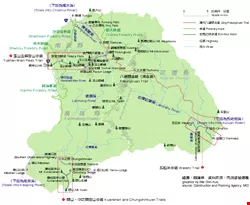
Yushan National Park and three eco-tour routes/graphics by Wei Chin-hua; source: Construction and Planning Agency, MOI
@List.JPG?w=522&h=410&mode=crop&format=webp&quality=80)

@List.jpg?w=522&h=410&mode=crop&format=webp&quality=80)


